King bioregion
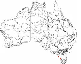
King is an interim Australian bioregion which includes King Island, the Hunter Islands, Robbins Island, and the north-western tip of Tasmania. The bioregion covers 425,567 hectares (1,051,600 acres).[1][2]
| King Tasmania | |||||||||||||||
|---|---|---|---|---|---|---|---|---|---|---|---|---|---|---|---|
 The interim Australian bioregions, with King in red | |||||||||||||||
| Area | 426 km2 (164.5 sq mi) | ||||||||||||||
| |||||||||||||||
King Island, located at the western entrance to Bass Strait, is home to a range of native plants and animals, some of which are under threat of extinction. Plant species under threat include, but are not restricted to, native orchids and ferns, whilst the animal species include the locally endemic threatened birds, the King Island brown thornbill (Acanthiza pusilla archibaldi) and King Island scrubtit (Acanthornis magna greeniana).[3]
See also
References
- "Interim Biogeographic Regionalisation for Australia (IBRA7) regions and codes". Department of Sustainability, Environment, Water, Population and Communities. Australian Government. 2012. Retrieved 13 January 2013.
- "Interim Biogeographic Regionalisation for Australia, Version 7" (PDF). Department of Sustainability, Environment, Water, Population and Communities. Australian Government. 2012. Retrieved 14 April 2015.
- "King Island Biodiversity Management Plan". Department of the Environment. Australian Government. 2012. Retrieved 3 June 2015.
Further reading
- Thackway, R.; Cresswell, I. D. (1995). An interim biogeographic regionalisation for Australia : a framework for setting priorities in the National Reserves System Cooperative Program, Version 4.0. Canberra: Australian Nature Conservation Agency, Reserve Systems Unit. ISBN 0-642-21371-2.
- Threatened Species Section (2012). King Island Biodiversity Management Plan (2012-2022) (PDF). Hobart: Department of Primary Industries, Parks, Water and Environment. ISBN 978-0-7246-6794-9.
This article is issued from Wikipedia. The text is licensed under Creative Commons - Attribution - Sharealike. Additional terms may apply for the media files.