Kohgiluyeh and Boyer-Ahmad province
Kohgiluyeh and Boyer-Ahmad province (Persian: استان کهگیلویه و بویراحمد, Ostān-e Kohgīlūye va Būyer-Ahmad; Luri: استان کهگیلویه و بِیرَمَد, Ostān-e Kohgīlūya-vo Beyramad) is one of the 31 provinces of Iran. It is in the southwest of the country, in Iran's Region 2,[3] and its capital is Yasuj. The province covers an area of 15,563 square kilometers, and in 2006 had a population of 621,428 in 125,779 households.[4] According to the National Population and Housing Census, the population of Kohgiluyeh and Boyer-Ahmad province in 2011 was 658,629 in 156,176 households.[5] The latest census in 2016 counted 713,052 inhabitants in 186,320 households.[1] The people mainly speak the Luri language.
Kohgiluyeh and Boyer-Ahmad province
استان کهگیلویه و بویراحمد | |
|---|---|
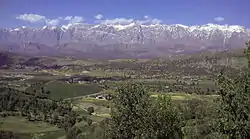 Dena Range as seen from the southwest | |
 Location of Kohgiluyeh and Boyer-Ahmad province within Iran | |
| Coordinates: 30.67°N 51.60°E | |
| Country | Iran |
| Region | Region 2 |
| Capital | Yasuj |
| Counties | 9 |
| Government | |
| • Governor-general | Ali Ahmadzadeh |
| Area | |
| • Total | 15,504 km2 (5,986 sq mi) |
| Population (2016)[1] | |
| • Total | 713,052 |
| • Density | 46/km2 (120/sq mi) |
| Time zone | UTC+03:30 (IRST) |
| Main language(s) | Lurish |
| HDI (2017) | 0.796[2] high · 16th |
Geography
Kohgiluyeh and Boyer-Ahmad province is located in the south of Iran, and shares borders with five provinces: Isfahan and Fars provinces to the east, Bushehr province to the south, Khuzestan to the west and Chaharmahal and Bakhtiari to the north.
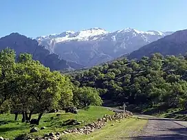
The province is mostly mountainous in terrain, part of the Zagros range. The highest point is the Dena summit with a height of 5,109 metres. The mountain range of Dena, which reaches an elevation of 4,000 metres, is located in the province, and is covered with oak forests. Another mountain is Khamin or Khami, which is located in Gachsaran County.
Administrative divisions

| Administrative Divisions | 2006[4] | 2011[5] | 2016[1] |
|---|---|---|---|
| Bahmai County | 35,067 | 37,048 | 38,136 |
| Basht County1 | — | 20,699 | 21,690 |
| Boyer-Ahmad County | 212,552 | 243,771 | 299,885 |
| Charam County2 | — | 32,159 | 33,543 |
| Dana County | 52,242 | 52,040 | 42,539 |
| Gachsaran County | 131,628 | 119,217 | 124,096 |
| Kohgiluyeh County | 189,939 | 153,695 | 131,351 |
| Landeh County2 | — | — | 21,812 |
| Margown County3 | — | — | — |
| Total | 621,428 | 658,629 | 713,052 |
| 1Separated from Gachsaran County 2Separated from Kohgiluyeh County 3Separated from Boyer-Ahmad County | |||
Cities
According to the 2016 census, 397,461 people (over 55% of the population of Kohgiluyeh and Boyer-Ahmad province) live in the following cities: Basht 10,764, Charam 15,218, Chitab 1,164, Dehdasht 57,036, Dishmok 5,791, Dogonbadan 96,728, Garab-e Sofla 545, Landeh 12,772, Likak 19,857, Madavan 18,078, Margown 3,135, Pataveh 2,284, Qaleh Raisi 3,269, Sarfaryab 1,995, Sisakht 7,855, Suq 6,438, and Yasuj 134,532.[1]
Colleges and universities
- University of Yasuj
- Islamic Azad University of Gachsaran
- Yasuj University of Medical Sciences
See also
- Seyyed Nasir Hosseini (the representative of Guardianship of the Islamic Jurist, in the province)
References
- "Census of the Islamic Republic of Iran, 1395 (2016)". AMAR (in Persian). The Statistical Center of Iran. p. 17. Archived from the original (Excel) on 2 November 2021. Retrieved 19 December 2022.
- "Sub-national HDI - Area Database - Global Data Lab". hdi.globaldatalab.org. Retrieved 2018-09-13.
- "همشهری آنلاین-استانهای کشور به ۵ منطقه تقسیم شدند (Provinces were divided into 5 regions)". Hamshahri Online (in Persian). 22 June 2014. Archived from the original on 23 June 2014.
- "Census of the Islamic Republic of Iran, 1385 (2006)". AMAR (in Persian). The Statistical Center of Iran. p. 17. Archived from the original (Excel) on 20 September 2011. Retrieved 25 September 2022.
- "Census of the Islamic Republic of Iran, 1390 (2011)" (Excel). Iran Data Portal (in Persian). The Statistical Center of Iran. p. 17. Retrieved 19 December 2022.
External links
- Official website of Kohgiluyeh and Buyer Ahmad Governorship
- A Boyer-Ahmad-i folk-song sung by Shusha Guppy in the 1970s: Girl from Boyer-Ahmad-i Tribe.
Places adjacent to Kohgiluyeh and Boyer-Ahmad province | ||||||||||||||||
|---|---|---|---|---|---|---|---|---|---|---|---|---|---|---|---|---|
| ||||||||||||||||
| Capital | 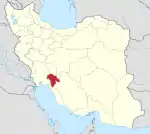 | ||||||||||||||||||
|---|---|---|---|---|---|---|---|---|---|---|---|---|---|---|---|---|---|---|---|
| Counties and cities |
| ||||||||||||||||||
| Sights |
| ||||||||||||||||||
| populated places | |||||||||||||||||||