Krásná (Cheb District)
Krásná (German: Schönbach bei Asch) is a municipality and village in Cheb District in the Karlovy Vary Region of the Czech Republic. It has about 600 inhabitants. It is the westernmost municipality of the country and in the Slavic-speaking world.
Krásná | |
|---|---|
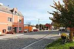 Main street and the post | |
 Flag  Coat of arms | |
 Krásná Location in the Czech Republic | |
| Coordinates: 50°14′6″N 12°10′5″E | |
| Country | |
| Region | Karlovy Vary |
| District | Cheb |
| First mentioned | 1331 |
| Government | |
| • Mayor | Luboš Pokorný |
| Area | |
| • Total | 21.85 km2 (8.44 sq mi) |
| Elevation | 643 m (2,110 ft) |
| Population (2023-01-01)[1] | |
| • Total | 626 |
| • Density | 29/km2 (74/sq mi) |
| Time zone | UTC+1 (CET) |
| • Summer (DST) | UTC+2 (CEST) |
| Postal code | 351 22 |
| Website | www |
Administrative parts
The village of Kamenná is an administrative part of Krásná.
Geography
Krásná is located about 22 km (14 mi) northwest of Cheb. It lies a salient region call Aš Panhandle on the border with Germany. The westernmost point of the Czech Republic is located in the municipality, at 50°15′9″N 12°5′26″E.
Krásná is situated in the Fichtel Mountains. The highest point is the hill Štítarský vrch at 716 m (2,349 ft).
History
.JPG.webp)
The first written mention of Krásná is from 1331 as a property of counts of Neuberg. Around 1400 Krásná was bought by the Zedtwitz family. This noble house controlled the whole of the Aš region for almost 500 years.[2]
In 1642 a small castle was built here, but in 1828 it suffered a catastrophic fire. In 1898, a municipal brewery was opened, although it is no longer in use. The castle was torn down in the 1950s.
After World War II, because of the buffer zone, several villages in the municipality (Štítary, Újezd, Elfhausen and Nové Domy) were torn down and became ghost towns.
Between 1976 and 1990, Krásná was one of the administrative parts of Aš, but in 1990 villages of Krásná and Kamenná separated and created a new municipality.[3]
Demographics
|
|
| ||||||||||||||||||||||||||||||||||||||||||||||||||||||
| Source: Censuses[4][5] | ||||||||||||||||||||||||||||||||||||||||||||||||||||||||
Transport
The train station Aš-předměstí is located near the village beyond the municipal border. A bus stop is also located in the municipality.
Sights
Krásná is poor in monuments. The only protected cultural monument is a rural house from the second half of the 19th century.[6]
Notable people
- Albin Dötsch (1872–1922), Austro-Hungarian politician
References
- "Population of Municipalities – 1 January 2023". Czech Statistical Office. 2023-05-23.
- "Historie obce" (in Czech). Obec Krásná. Retrieved 2020-12-18.
- "Historický lexikon obcí České republiky 1869–2011" (in Czech). Czech Statistical Office. 2015-12-21. pp. 221, 255.
- "Historický lexikon obcí České republiky 1869–2011 – Okres Cheb" (in Czech). Czech Statistical Office. 2015-12-21. pp. 5–6.
- "Population Census 2021: Population by sex". Public Database. Czech Statistical Office. 2021-03-27.
- "Výsledky vyhledávání: Kulturní památky, obec Krásná". Ústřední seznam kulturních památek (in Czech). National Heritage Institute. Retrieved 2023-10-27.