Stará Voda (Cheb District)
Stará Voda (German: Altwasser) is a municipality and village in Cheb District in the Karlovy Vary Region of the Czech Republic. It has about 500 inhabitants.
Stará Voda | |
|---|---|
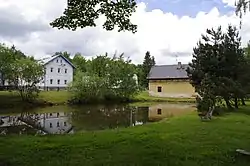 A pond in the centre | |
 Flag  Coat of arms | |
 Stará Voda Location in the Czech Republic | |
| Coordinates: 49°59′30″N 12°35′45″E | |
| Country | |
| Region | Karlovy Vary |
| District | Cheb |
| First mentioned | 1587 |
| Area | |
| • Total | 54.01 km2 (20.85 sq mi) |
| Elevation | 605 m (1,985 ft) |
| Population (2023-01-01)[1] | |
| • Total | 501 |
| • Density | 9.3/km2 (24/sq mi) |
| Time zone | UTC+1 (CET) |
| • Summer (DST) | UTC+2 (CEST) |
| Postal codes | 350 02, 353 01 |
| Website | www |
Administrative parts
Villages of Sekerské Chalupy and Vysoká are administrative parts of Stará Voda.
Geography
Stará Voda is located about 17 km (11 mi) southeast of Cheb, on the border with Germany. The eastern part of the municipal territory with the village of Stará Voda lies in the Upper Palatine Forest Foothills, but most of the municipality lies in the Upper Palatine Forest. The highest point is the second highest peak of the entire Upper Palatine Forest, Dyleň at 940 m (3,080 ft) above sea level.
This article is issued from Wikipedia. The text is licensed under Creative Commons - Attribution - Sharealike. Additional terms may apply for the media files.