Lac-Simon, Outaouais
Lac-Simon is a town and municipality in the Outaouais region of Quebec, Canada, part of the Papineau Regional County Municipality.
Lac-Simon | |
|---|---|
 | |
_Quebec_location_diagram.png.webp) Location within Papineau RCM | |
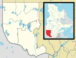 Lac-Simon Location in western Quebec | |
| Coordinates: 45°54′N 75°06′W[1] | |
| Country | |
| Province | |
| Region | Outaouais |
| RCM | Papineau |
| Settled | 1845 |
| Constituted | January 1, 1881 |
| Named for | Marie-Louise Cimon[1] |
| Government | |
| • Mayor | Gaston A. Tremblay |
| • Federal riding | Argenteuil—Papineau—Mirabel |
| • Prov. riding | Papineau |
| Area | |
| • Total | 121.90 km2 (47.07 sq mi) |
| • Land | 95.65 km2 (36.93 sq mi) |
| Population (2021)[3] | |
| • Total | 1,057 |
| • Density | 11.1/km2 (29/sq mi) |
| • Pop 2016-2021 | |
| • Dwellings | 1,304 |
| Time zone | UTC−5 (EST) |
| • Summer (DST) | UTC−4 (EDT) |
| Postal code(s) | |
| Area code | 819 |
| Highways | |
| Website | www |
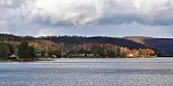
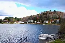
It is known for its sandy beaches on Lake Simon and provides services to vacationers and campers.
History
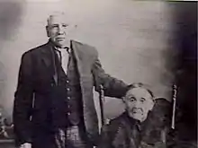
In 1845, the Métis Amable LeBlanc and his wife Marie-Louise Cimon, the niece of Basile Outik, chief of the Oka Indian tribe, went to settle on an island in the middle of a lake located 121 kilometres (75 mi) north-west of Oka. Eight families left with him to this region where hunting and fishing were very good. Three of these families were related to the parents of his wife and from then on, the residents of Oka, and later those of Montebello, called this lake "Lake Cimon", which became "Lake Simon".[4] The largest island in the lake is now called White Duck Island (Île du Canard Blanc) in honour of Amable LeBlanc who was nicknamed "White Duck" in reference to his slightly lighter skin colour as compared to his native relatives.[5]
Starting in 1852, Franco-Catholic colonists began to settle at the lake, working as log drivers, loggers, or farmers.[5] In 1857, a mission was established.[1] In 1864, Hartwell Township is formed (named after a place in central Buckinghamshire, England),[6] followed a few years later by the United Township Municipality of Hartwell-et-Suffolk. In 1880, the mission attained the status of parish under the name of Saint-Felix-de-Valois.[1]
In 1881, Hartwell-et-Suffolk separated and formed the Township Municipality of Hartwell and the Township Municipality of Suffolk. In 1893, Hartwell was merged with Preston Township, becoming the United Township Municipality of Hartwell-et-Preston.
In 1936, the united townships were separated again and formed the Township Municipality of Hartwell and the Municipality of Duhamel. In 1958, Hartwell became the Parish Municipality of Chénéville and finally became the Municipality of Lac-Simon in 1965.[1]
Lac-Simon's development as a resort area began in the 1950s, and accelerated when the provincial government acquired sites bordering the lake and opened a campground. Today, Lac-Simon is a popular year-round vacation resort.[5]
Demographics
| 2021 | 2016 | 2011 | |
|---|---|---|---|
| Population | 1,057 (+12.0% from 2016) | 944 (-4.1% from 2011) | 984 (13.2% from 2006) |
| Land area | 95.65 km2 (36.93 sq mi) | 97.48 km2 (37.64 sq mi) | 97.37 km2 (37.59 sq mi) |
| Population density | 11.1/km2 (29/sq mi) | 9.7/km2 (25/sq mi) | 10.1/km2 (26/sq mi) |
| Median age | 60 (M: 60.4, F: 59.2) | 59.6 (M: 60.4, F: 58.8) | 57.5 (M: 58.0, F: 56.9) |
| Private dwellings | 555 (total) | 1,373 (total) | 1,145 (total) |
| Median household income | $68,500 | $57,088 |
| Year | Pop. | ±% |
|---|---|---|
| 1986 | 471 | — |
| 1991 | 583 | +23.8% |
| 1996 | 667 | +14.4% |
| 2001 | 683 | +2.4% |
| 2006 | 869 | +27.2% |
| 2011 | 984 | +13.2% |
| 2016 | 944 | −4.1% |
| 2021 | 1,057 | +12.0% |
Mother tongue:[3]
- English as first language: 3.8%
- French as first language: 94.8%
- English and French as first language: 0.5%
- Other as first language: 0.9%
References
- "Reference number 33359 in Banque de noms de lieux du Québec". toponymie.gouv.qc.ca (in French). Commission de toponymie du Québec.
- "Geographic code 80095 in the official Répertoire des municipalités". www.mamh.gouv.qc.ca (in French). Ministère des Affaires municipales et de l'Habitation.
- "Data table, Census Profile, 2021 Census of Population - Lac-Simon, Municipalité (MÉ) [Census subdivision], Quebec". 9 February 2022.
- "Lac Simon (lake)" (in French). Commission de toponymie du Québec. Retrieved 2008-12-02.
- "Centre touristique du Lac-Simon, History". La Sépaq. Retrieved 2008-12-04.
- "Hartwell (Canton)" (in French). Commission de toponymie du Québec. Retrieved 2008-12-03.
- "2021 Community Profiles". 2021 Canadian Census. Statistics Canada. February 4, 2022. Retrieved 2022-08-23.
- "2016 Community Profiles". 2016 Canadian Census. Statistics Canada. August 12, 2021. Retrieved 2019-12-20.
- "2011 Community Profiles". 2011 Canadian Census. Statistics Canada. March 21, 2019. Retrieved 2019-12-20.
- "2006 Community Profiles". 2006 Canadian Census. Statistics Canada. August 20, 2019.
- "2001 Community Profiles". 2001 Canadian Census. Statistics Canada. July 18, 2021.
External links
![]() Media related to Lac-Simon, Outaouais, Quebec at Wikimedia Commons
Media related to Lac-Simon, Outaouais, Quebec at Wikimedia Commons
Places adjacent to Lac-Simon, Outaouais | ||||||||||||||||
|---|---|---|---|---|---|---|---|---|---|---|---|---|---|---|---|---|
| ||||||||||||||||
| Cities | |
|---|---|
| Municipalities | |
| Townships | |
| |