Plaisance, Quebec
Plaisance is a municipality in Papineau Regional County Municipality in western Quebec, Canada. The village is situated on the Ottawa River near the mouth of the Petite-Nation River, 70 km from Gatineau and 160 km from Montreal on Route 148.
Plaisance | |
|---|---|
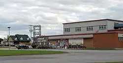 Plaisance cheese factory | |
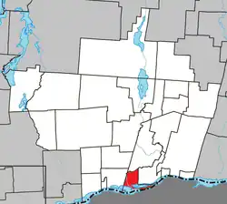 Location within Papineau RCM | |
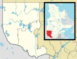 Plaisance Location in western Quebec | |
| Coordinates: 45°37′N 75°07′W[1] | |
| Country | Canada |
| Province | Quebec |
| Region | Outaouais |
| RCM | Papineau |
| Constituted | October 31, 1900 |
| Government | |
| • Mayor | Paulette Lalande |
| • Federal riding | Argenteuil—Papineau—Mirabel |
| • Prov. riding | Papineau |
| Area | |
| • Total | 50.20 km2 (19.38 sq mi) |
| • Land | 36.15 km2 (13.96 sq mi) |
| Population (2016)[3] | |
| • Total | 1,088 |
| • Density | 30.1/km2 (78/sq mi) |
| • Pop 2011-2016 | |
| • Dwellings | 537 |
| Time zone | UTC−5 (EST) |
| • Summer (DST) | UTC−4 (EDT) |
| Postal code(s) | |
| Area code | 819 |
| Highways | |
| Website | www |
The village is well known for its waterfalls located just north of town as well as a local cheese factory which was previously quite popular in the Outaouais region. There is also the Plaisance National Park, a large bird reserve between the main highway and the Ottawa River.
Demographics
Canada census – Plaisance community profile
| 2021 | 2016 | 2011 | |
|---|---|---|---|
| Population | 1,129 (+3.8% from 2016) | 1,088 (-1.4% from 2011) | 1,103 (7.7% from 2006) |
| Land area | 36.21 km2 (13.98 sq mi) | 36.15 km2 (13.96 sq mi) | 36.23 km2 (13.99 sq mi) |
| Population density | 31.2/km2 (81/sq mi) | 30.1/km2 (78/sq mi) | 30.4/km2 (79/sq mi) |
| Median age | 51.2 (M: 50.8, F: 51.6) | 47.8 (M: 46.4, F: 49.7) | 46.8 (M: 45.0, F: 48.3) |
| Private dwellings | 505 (total) | 537 (total) | 514 (total) |
| Median household income | $58,048 | $48,305 |
| Year | Pop. | ±% |
|---|---|---|
| 1986 | 948 | — |
| 1991 | 992 | +4.6% |
| 1996 | 992 | +0.0% |
| 2001 | 1,004 | +1.2% |
| 2006 | 1,024 | +2.0% |
| 2011 | 1,103 | +7.7% |
| 2016 | 1,088 | −1.4% |
| Population amounts are not adjusted for boundary changes. Source: Statistics Canada | ||
Mother tongue:[3]
- English as first language: 2.3%
- French as first language: 96.8%
- English and French as first language: 0.5%
- Other as first language: 0%
References
- "Reference number 49772 in Banque de noms de lieux du Québec". toponymie.gouv.qc.ca (in French). Commission de toponymie du Québec.
- "Geographic code 80045 in the official Répertoire des municipalités". www.mamh.gouv.qc.ca (in French). Ministère des Affaires municipales et de l'Habitation.
- "Plaisance, Quebec (Code 2480045) Census Profile". 2016 census. Government of Canada - Statistics Canada.
- "2021 Community Profiles". 2021 Canadian Census. Statistics Canada. February 4, 2022. Retrieved 2022-04-27.
- "2016 Community Profiles". 2016 Canadian Census. Statistics Canada. August 12, 2021. Retrieved 2020-01-30.
- "2011 Community Profiles". 2011 Canadian Census. Statistics Canada. March 21, 2019. Retrieved 2020-01-30.
- "2006 Community Profiles". 2006 Canadian Census. Statistics Canada. August 20, 2019.
- "2001 Community Profiles". 2001 Canadian Census. Statistics Canada. July 18, 2021.
External links
 Media related to Plaisance, Quebec at Wikimedia Commons
- Village web site
Places adjacent to Plaisance, Quebec | |
|---|---|
| Cities | |
|---|---|
| Municipalities | |
| Townships | |
| |
This article is issued from Wikipedia. The text is licensed under Creative Commons - Attribution - Sharealike. Additional terms may apply for the media files.