List of State Register of Heritage Places in the Shire of Capel
The State Register of Heritage Places is maintained by the Heritage Council of Western Australia. As of 2023, 189 places are heritage-listed in the Shire of Capel,[1] of which eleven are on the State Register of Heritage Places.[2]
List
The Western Australian State Register of Heritage Places, as of 2023, lists the following eleven state registered places within the Shire of Capel:
| Place name | Place # | Street number | Street name | Suburb or town | Co-ordinates | Notes & former names | Photo |
|---|---|---|---|---|---|---|---|
| Higgins Cut (former) | 368 | Springfield, Ludlow Road North | Capel | 33.541136°S 115.493872°E | |||
| St John's Anglican Church, Capel | 436 | 88 | Capel Drive | Capel | 33.552323°S 115.562937°E | Site of original stone church | 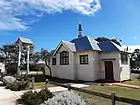 |
| Minninup Homestead | 440 | Mangles Road | Minninup | 33.477328°S 115.555545°E | |||
| St Louis Catholic Church, Boyanup | 442 | Corner | Bridge Street & Thomas Street | Boyanup | 33.482357°S 115.729462°E | 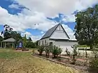 | |
| Lexden Park | 3022 | 2 | Jamieson Road | Capel | 33.567123°S 115.576951°E | Payne's Mill, Mount Pleasant | |
| Slab Hut, Boyanup Farm | 3089 | South Western Highway | Boyanup | 33.498827°S 115.729387°E | Bessneut Springs, Smith's Cottage (former), Slab Hut, Boyanup Farm |  | |
| Lime Kilns | 4622 | Ludlow Road North | Capel | 33.537747°S 115.516337°E | Lara Lime Kilns, Coolingup Lime Works | ||
| Forestry Houses, State Forest No 2 | 14872 | Ludlow Road | Ludlow | 33.602226°S 115.480426°E | |||
| Single Men's Quarters, State Forest No 2 | 14874 | Ludlow Road | Ludlow River | 33.601205°S 115.478334°E | |||
| Ludlow Forestry Mill and Settlement | 15834 | Corner Ludlow Road North & Tuart Drive | Ludlow | 33.601764°S 115.479149°E | Ludlow Forestry Settlement |  | |
| Minninup Homestead Precinct | 24632 | Mangles Road | Capel | 33.477328°S 115.555545°E |
References
- "Shire of Capel Heritage Places". inherit.stateheritage.wa.gov.au. Heritage Council of Western Australia. Retrieved 25 February 2023.
- "Shire of Capel State Register of Heritage Places". inherit.stateheritage.wa.gov.au. Heritage Council of Western Australia. Retrieved 25 February 2023.
This article is issued from Wikipedia. The text is licensed under Creative Commons - Attribution - Sharealike. Additional terms may apply for the media files.