List of State Register of Heritage Places in the Shire of York
The State Register of Heritage Places is maintained by the Heritage Council of Western Australia. As of 2023, 321 places are heritage-listed in the Shire of York,[1] of which 34 are on the State Register of Heritage Places.[2]
List
The Western Australian State Register of Heritage Places, as of 2023, lists the following 34 state registered places within the Shire of York:
| Place name | Place # | Location | Suburb or town | Co-ordinates | Notes & former names | Photo |
|---|---|---|---|---|---|---|
| St Andrew's Anglican Church & Cemetery, Greenhills | 2821 | Quairading Road | Greenhills | 31.9447°S 116.9768°E | ||
| Wansbrough House | 2830 | 22 Avon Terrace | York | 31.8968°S 116.7704°E | ||
| York Police Station, Court House & Gaol | 2852 | 124 Avon Terrace | York | 31.8887°S 116.7687°E | Old York Courthouse and Police Station, York Courthouse Complex | 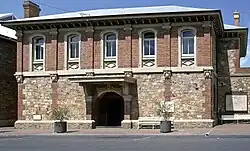 |
| York Post Office | 2855 | 134 Avon Terrace | York | 31.8884°S 116.7686°E | 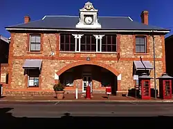 | |
| Old York Fire Station | 2860 | 151 Avon Terrace | York | 31.8876°S 116.7682°E | Council Chambers (former), Community Centre | 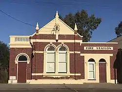 |
| Balladong Farm Group | 2867 | Corner Parker Road & Avon Terrace | York | 31.8968°S 116.7704°E | ||
| Eliza's Cottage | 2868 | 9 Revett Place | York | 31.89864°S 116.7692°E | Lookout for Trains Cottage, Burtons Cottage |  |
| Old York Hospital | 2869 | Brook Street | York | 31.893°S 116.7747°E | Avonmoore | 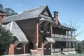 |
| Residency Museum | 2870 | 5 Brook Street | York | 31.8928°S 116.7754°E | Residency (former) Nursing Quarters | .JPG.webp) |
| York Flour Mill | 2872 | 10 Henrietta Street | York | 31.8939°S 116.7663°E | Jah Roc Furniture, York Flour Milling Co. Ltd, Empire Roller Flour Mill | 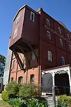 |
| Faversham House | 2876 | 24 Grey Street | York | 31.8855°S 116.7663°E | 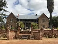 | |
| York Primary School | 2877 | Howick Street | York | 31.8894°S 116.7668°E | York Mixed, York Junior High School, York Boys School |  |
| St Patrick's Catholic Church, Presbytery & Hall | 2878 | 22 South Street | York | 31.8903°S 116.7667°E | 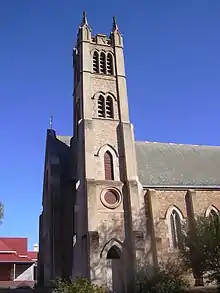 | |
| Convent of Mercy and School (former) | 2879 | 29 South Street | York | 31.8911°S 116.7665°E | Radio 101.3 York FM, Youth Hostel, York Telecentre | |
| York Town Hall | 2880 | 79-81 Avon Terrace | York | 31.8916°S 116.7682°E | & York Roll of Honour | 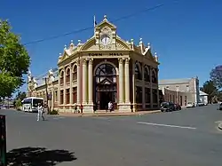 |
| Two Houses and Grounds | 2882 | 124 Avon Terrace | York | 31.8887°S 116.7687°E | Part of York Police Station, Court House & Gaol Precinct (2852), Police Quarters (former), Courthouse and Police Station Cottages | |
| Holy Trinity Church | 2883 | Corner Newcastle & Pool Streets | York | 31.8865°S 116.7724°E | Holy Trinity Church & Hall | .jpg.webp) |
| Marwick's Shed | 2884 | 19-21 Newcastle Street | York | 31.8839°S 116.7730°E | Marwicks Barn | 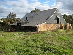 |
| Bridge House & Grounds | 2893 | Redmile Road | York | 31.8937°S 116.7725°E | ||
| St. Patrick's Convent School (former) | 2898 | Lots 800-1 South Street | York | Part of Convent of Mercy and School (former) Precinct (2879), York Public Library | ||
| York Railway Station (former) | 2899 | 13 Railway Street | York | 31.8919°S 116.7658°E |  | |
| York Hospital Heritage Precinct | 3019 | Brook Street | York | Parent place of Old York Hospital (2869) and Residency Museum (2870) | ||
| Holy Trinity Church, Hall & Rectory | 3213 | Newcastle Street | York | Parent place of Holy Trinity Church (2883) and Anglican Rectory and Grounds (4201) | ||
| York-Beverley Racecourse | 3426 | North Road | York | 31.8613°S 116.7733°E | including Grandstand | |
| Monger's Trading Post (former) | 3980 | 165 Avon Terrace | York | 31.8862°S 116.7682°E | Sandalwood Yard | 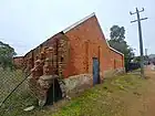 |
| St Ronan's Well, York | 4183 | Great Southern Highway | St Ronans | 31.8861°S 116.6022°E | St Ronan's Well and Conservation Area | |
| Korrawilla Homestead Group | 4184 | Corner York & Quairading Road | Greenhills | 31.9414°S 116.9848°E | Greenhills Farm, Korrawilla | |
| Anglican Rectory and Grounds | 4201 | Suburban Street | York | Part of Holy Trinity Church, Hall & Rectory (3213) | ||
| Imperial Hotel | 10725 | 83 Avon Terrace | York | 31.8911°S 116.7682°E | 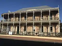 | |
| York & Districts Co-Op & Quarters | 11551 | 138 Avon Terrace | York | 31.8880°S 116.7687°E | York District Farmers' Cooperative, Edwards General Store | |
| Gwambygine Farm and Pool | 14880 | Intersection of Ovens Road & Great Southern Highway | York | 31.9809°S 116.8060°E | Gwambygine Homestead |  |
| Sandalwood Yards | 23466 | Corner Avon Terrace and Ford Street | York | Part of Monger's Trading Post (3980) | ||
| Monger's Yard | 23467 | 165 Avon Terrace | York | Part of Monger's Trading Post (3980) | ||
| Charcoal Burner Site, Mount Observation | 25664 | 526 Yarra Road | Mount Observation | 31.9360°S 116.4575°E |
Former places
The following place has been removed from the State Register of Heritage Places within the Shire of York:
| Place name | Place # | Location | Suburb or town | Co-ordinates | Deregistered | Notes & former names | Photo |
|---|---|---|---|---|---|---|---|
| War Memorial, York | 2891 | Railway Street | York | 31.8914°S 116.766°E | 1 July 2021 | Monument and Park, York, Fallen Soldier's Memorial, York War Memorial |
References
- "Shire of York Heritage Places". inherit.stateheritage.wa.gov.au. Heritage Council of Western Australia. Retrieved 25 February 2023.
- "Shire of York State Register of Heritage Places". inherit.stateheritage.wa.gov.au. Heritage Council of Western Australia. Retrieved 25 February 2023.
This article is issued from Wikipedia. The text is licensed under Creative Commons - Attribution - Sharealike. Additional terms may apply for the media files.