List of State Register of Heritage Places in the Shire of Northam
The State Register of Heritage Places is maintained by the Heritage Council of Western Australia. As of 2023, 166 places are heritage-listed in the Shire of Northam,[1][N1] of which 40 are on the State Register of Heritage Places.[2][N2]
List
The Western Australian State Register of Heritage Places, as of 2023, lists the following 40 state registered places within the Shire of Northam:
| Place name | Place # | Street number | Street name | Suburb or town | Co-ordinates | Notes & former names | Photo |
|---|---|---|---|---|---|---|---|
| Morby Farm Cottage, Northam | 1837 | 70 | Katrine Road | Northam | 31.638058°S 116.676008°E | ||
| Buckland Homestead and Farm Buildings | 1843 | Buckland Road | Irishtown, Northam | 31.565005°S 116.618522°E | |||
| Northam Fire Station No 2 & Quarters (former) | 1852 | 87 | Duke Street | Northam | 31.656136°S 116.673246°E | Northam's Avon Descent Assoc. Headquarters | |
| Colonial Tavern & Stables, Northam | 1855 | 197 | Duke Street West | Northam | 31.66303°S 116.665715°E | McCarthey's Hotel, Club Tavern, Club Hotel, Duke's Inn | 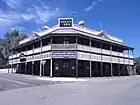 |
| Old Methodist Church & Hall (former) | 1856 | 103 | Duke Street East | Northam | 31.657178°S 116.672325°E | Uniting Church, Methodist Church | |
| Northam Railway Station (former) | 1859 | 401 | Fitzgerald Street | Northam | 31.660893°S 116.662742°E | Northam Railway Museum | 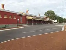 |
| ANZ Bank, Northam | 1861 | 133 | Fitzgerald Street | Northam | 31.652589°S 116.673144°E | Union Bank | |
| Shamrock Hotel, Northam | 1865 | 110 | Fitzgerald Street | Northam | 31.651924°S 116.672995°E | Riley's Bar, The Farmer's Home Hotel | |
| Northam Post Office & Quarters | 1867 | 239-243 | Fitzgerald Street | Northam | 31.6551°S 116.6703°E |  | |
| Northam Municipal Chambers site | 1869 | Fitzgerald Street | Northam | [?] | Demolished in 1981 | ||
| Commonwealth Bank, Northam | 1871 | 181 | Fitzgerald Street | Northam | 31.653967°S 116.671656°E | ||
| Bank of New South Wales (NSW) (former), Northam | 1872 | 161 | Fitzgerald Street | Northam | 31.653593°S 116.67205°E | Westpac Bank, Challenge Bank, Western Australian Bank (former) | |
| Fermoy House (former), Northam | 1874 | 1 | Lance Street | Northam | 31.657749°S 116.678331°E | Throssell Homestead, St Joseph's Marist Brothers School | |
| Uralia | 1876 | 59 | Gordon Street | Northam | 31.657872°S 116.67357°E | St John of God Hospital, Rosalyn | |
| Northam Town Hall/Lesser Hall | 1877 | Wellington Street | Northam | 31.656213°S 116.671634°E | 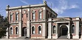 | ||
| Byfield House | 1878 | 30 | Gordon Street | Northam | 31.659233°S 116.677005°E | ||
| The Residency | 1880 | 60 | Habgood Street | Northam | 31.66682°S 116.665349°E | The Magistrate's Residence (former), The Old Resident Magistrate's Home | |
| Northam State School (former) | 1881 | 33 | Wellington Street | Northam | 31.651925°S 116.675101°E | Avon Valley Arts Centre Workshop, Northam Primary School, Old Girls School (former) | |
| Mitchell House | 1882 | 15-17 | Hawes Street | Northam | 31.652257°S 116.676692°E | Bona Vista | |
| Northam Senior High School | 1883 | 30 | Kennedy Street | Northam | 31.647025°S 116.668159°E | ||
| John Morrell's Grave | 1885 | Goomalling Road | Northam | 31.639867°S 116.679629°E | |||
| Northam Police Station and Court House | 1890 | 114 | Wellington Street East | Northam | 31.656951°S 116.669191°E | ||
| St John's Anglican Church & Parish Hall, Northam | 1891 | 11 | Wellington Street | Northam | 31.6507°S 116.675585°E | 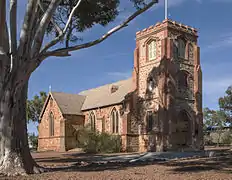 | |
| Northam Post Office (former) | 1892 | 33 | Wellington Street | Northam | 31.652413°S 116.674760°E | Avon Valley Arts Centre, Old Post Office | |
| Northam Police Station | 1896 | 297 | Fitzgerald Street East | Northam | 31.656951°S 116.669191°E | ||
| Railway Institute, Northam | 1898 | 182 | Wellington Street West | Northam | 31.660693°S 116.665076°E | WA Govt Railways & Tramways Institute | |
| Bardeen | 3414 | 866 | Dumbarton Road | Irishtown | 31.58699°S 116.604011°E | ||
| Poole Street Footbridge | 3549 | Poole Street | Northam | 31.659984°S 116.658577°E | West Northam Footbridge | ||
| Northam Cemetery | 3976 | Katrine Road | Northam | 31.636405°S 116.657887°E | Hubert Bartlett-Day's Tree, Pioneer Cemetery, Little Pansy's Tree Northam Cemetery | ||
| Northam Army Camp | 6126 | Great Eastern Highway | Burlong | 31.672807°S 116.62075°E | Department of Immigration AccommodationCentre | ||
| Chauncy's Cairn | 8565 | North of | Cobb Road | Woottating | 31.896422°S 116.370776°E | ||
| Curdnatta | 10881 | 22 | Newcastle Road | Northam | 31.652913°S 116.664496°E | ||
| Town Council Offices (former) & Library, Northam | 10907 | 298 | Fitzgerald Street East | Northam | 31.65587°S 116.668193°E | Northam Library | |
| Clackline Bridge | 10910 | Lockyer Road | Clackline | 31.7206°S 116.522°E | Viaduct | .jpg.webp) | |
| Hoopers Winery & Surroundings | 10917 | 9 | Yates Street | Bakers Hill | 31.746202°S 116.455451°E | Mount Baker Estate, Keanes Vineyards | |
| National Australia Bank, Northam | 14788 | 141 | Fitzgerald Street | Northam | 31.652988°S 116.672715°E | ||
| Uniting Church & Hall, Northam | 16300 | 103 | Duke Street East | Northam | 31.657178°S 116.672325°E | Methodist Church & Hall | |
| Goldfields Water Supply Scheme | 16610 | Listed under the Coolgardie, Cunderdin, Kellerberrin, Kalgoorlie–Boulder, Merredin, Mundaring, Northam, Tammin and Yilgarn State Heritage lists | Stretches from Mundaring Weir in Perth to the Eastern Goldfields, particularly Coolgardie and Kalgoorlie | 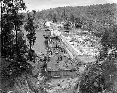 | |||
| Police Station (former) | 24983 | 128 | Wellington Street | Northam | 31.65744°S 116.669107°E | Community Centre Old Police Station Police | |
| Northam Courthouse | 25062 | 114 | Wellington Street | Northam | 31.657066°S 116.669457°E |
Notes
- ^[N1] A search for Northam LGA returns 392 hits, of which 221 are for the Northampton LGA, 166 are for Northam LGA while five are multi-region entries
- ^[N2] A search for Northam LGA returns 70 hits, of which 30 are for the Northampton LGA and 40 for Northam LGA
- ^[?] No coordinates specified by Inherit database
References
- "Shire of Northam Heritage Places". inherit.stateheritage.wa.gov.au. Heritage Council of Western Australia. Retrieved 25 February 2023.
- "Shire of Northam State Register of Heritage Places". inherit.stateheritage.wa.gov.au. Heritage Council of Western Australia. Retrieved 25 February 2023.
This article is issued from Wikipedia. The text is licensed under Creative Commons - Attribution - Sharealike. Additional terms may apply for the media files.