List of listed buildings in Closeburn, Dumfries and Galloway
List
| Name | Location | Date Listed | Grid Ref. [note 1] | Geo-coordinates | Notes | LB Number [note 2] | Image |
|---|---|---|---|---|---|---|---|
| Auldgirth Inn | 55°09′41″N 3°42′27″W | Category B | 3967 |  Upload Photo | |||
| Ballochan Linn Railway Viaduct | 55°10′10″N 3°42′44″W | Category B | 3968 | Upload Photo | |||
| Dalgarnock Old Burial Ground | 55°13′26″N 3°46′07″W | Category B | 4013 | Upload Photo | |||
| Blackwood: House, Cottages and Walled Garden | 55°09′57″N 3°42′59″W | Category B | 4041 | Upload Photo | |||
| Cample Viaduct | 55°13′45″N 3°44′05″W | Category B | 4002 | 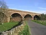
| |||
| Claughrie | 55°10′50″N 3°42′30″W | Category B | 4003 | Upload Photo | |||
| Locherben Farmhouse | 55°15′25″N 3°38′30″W | Category C(S) | 3949 | Upload Photo | |||
| Auchenrennie | 55°10′58″N 3°42′34″W | Category B | 3965 | Upload Photo | |||
| Closeburn Church and Gatepiers | 55°12′45″N 3°43′28″W | Category B | 4007 | 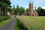
| |||
| Closeburn Mains Walled Garden | 55°12′55″N 3°43′03″W | Category C(S) | 4010 | Upload Photo | |||
| 64 Closeburn Village | 55°12′45″N 3°44′07″W | Category B | 4012 | Upload Photo | |||
| Kirkland Lodge | 55°13′06″N 3°45′30″W | Category C(S) | 3948 | Upload Photo | |||
| Park Village, Limekilns | 55°12′13″N 3°43′06″W | Category B | 167 | Upload Photo | |||
| Shawsholm House | 55°12′15″N 3°45′09″W | Category B | 169 | Upload Photo | |||
| Auchencairn Farmhouse and Steading | 55°11′54″N 3°41′39″W | Category C(S) | 3964 | Upload Photo | |||
| Cample Mill | 55°13′46″N 3°44′00″W | Category B | 4001 | 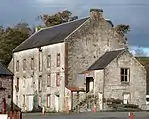
| |||
| Closeburn Mains (formerly Closeburn Hall Stables) | 55°12′59″N 3°43′03″W | Category C(S) | 4009 | 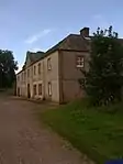
| |||
| Closeburn School | 55°12′49″N 3°43′41″W | Category B | 4011 | 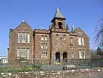
| |||
| Kirkbog Farmhouse | 55°13′35″N 3°46′25″W | Category C(S) | 3946 | Upload Photo | |||
| Kirkland House | 55°13′07″N 3°45′45″W | Category C(S) | 3947 | Upload Photo | |||
| Wallacehall Assessment Centre (former Academy and Schoolhouse) | 55°12′49″N 3°43′35″W | Category A | 3953 | Upload Photo | |||
| Gubhill Farmhouse | 55°12′47″N 3°37′00″W | Category C(S) | 3945 | Upload Photo | |||
| Newton Farmhouse and Steading Range adjoining at South | 55°14′54″N 3°43′27″W | Category B | 3950 | Upload Photo | |||
| Auldgirth Bridge | 55°09′34″N 3°42′35″W | Category A | 3966 | 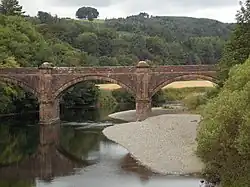
| |||
| Shotts Smithy | 55°12′13″N 3°42′53″W | Category B | 3951 | Upload Photo | |||
| Townpark | 55°13′04″N 3°43′07″W | Category B | 3952 | Upload Photo | |||
| Closeburn Castle | 55°12′41″N 3°43′06″W | Category B | 4004 | 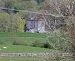
| |||
| Closeburn Castle South Lodge and Gatepiers | 55°12′25″N 3°42′55″W | Category B | 4006 | Upload Photo | |||
| Rosebank | 55°13′35″N 3°46′08″W | Category B | 168 | Upload Photo | |||
| Closeburn Castle Gatepiers (to East of Castle) | 55°12′42″N 3°43′01″W | Category C(S) | 4005 | Upload Photo | |||
| Closeburn Old Church, Kirkpatrick of Closeburn Mausoleum and Churchyard Enclosure | 55°12′46″N 3°43′28″W | Category B | 4008 | 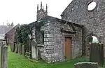
| |||
| Dressertland Farm Roofed Midden | 55°13′42″N 3°43′17″W | Category B | 3944 | Upload Photo |
Key
The scheme for classifying buildings in Scotland is:
- Category A: "buildings of national or international importance, either architectural or historic; or fine, little-altered examples of some particular period, style or building type."[1]
- Category B: "buildings of regional or more than local importance; or major examples of some particular period, style or building type, which may have been altered."[1]
- Category C: "buildings of local importance; lesser examples of any period, style, or building type, as originally constructed or moderately altered; and simple traditional buildings which group well with other listed buildings."[1]
In March 2016 there were 47,288 listed buildings in Scotland. Of these, 8% were Category A, and 50% were Category B, with the remaining 42% being Category C.[2]
Notes
- Sometimes known as OSGB36, the grid reference (where provided) is based on the British national grid reference system used by the Ordnance Survey.
• "Guide to National Grid". Ordnance Survey. Retrieved 12 December 2007.
• "Get-a-map". Ordnance Survey. Retrieved 17 December 2007. - Historic Environment Scotland assign a unique alphanumeric identifier to each designated site in Scotland, for listed buildings this always begins with "LB", for example "LB12345".
References
- All entries, addresses and coordinates are based on data from Historic Scotland. This data falls under the Open Government Licence
- "What is Listing?". Historic Environment Scotland. Retrieved 29 May 2018.
- Scotland's Historic Environment Audit 2016 (PDF). Historic Environment Scotland and the Built Environment Forum Scotland. pp. 15–16. Retrieved 29 May 2018.
This article is issued from Wikipedia. The text is licensed under Creative Commons - Attribution - Sharealike. Additional terms may apply for the media files.