List of listed buildings in Lochmaben, Dumfries and Galloway
This is a list of listed buildings in the civil parish of Lochmaben in Dumfries and Galloway, Scotland.
List
| Name | Location | Date Listed | Grid Ref. [note 1] | Geo-coordinates | Notes | LB Number [note 2] | Image |
|---|---|---|---|---|---|---|---|
| Castle Street, Bruce Arms | 55°07′43″N 3°26′31″W | Category B | 37538 | 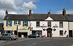
| |||
| High Street, Lochmaben Parish Church Boundary Wall and Gatepiers (St Magdalene's) | 55°07′35″N 3°26′19″W | Category A | 37539 | 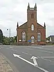
| |||
| 61 (Castle Grove), 63, 65 High Street (also known as 1, 2, 3 Church Place) | 55°07′36″N 3°26′21″W | Category B | 37548 |  Upload Photo | |||
| 34 High Street, The Old Schoolhouse | 55°07′41″N 3°26′24″W | Category B | 37553 | Upload Photo | |||
| Corncockle Farmhouse | 55°09′57″N 3°26′27″W | Category B | 9968 | Upload Photo | |||
| 5, 7 High Street | 55°07′44″N 3°26′31″W | Category B | 37542 | Upload Photo | |||
| 4 High Street | 55°07′45″N 3°26′30″W | Category B | 37549 | Upload Photo | |||
| 6 High Street, Balcarres | 55°07′45″N 3°26′28″W | Category B | 37550 | Upload Photo | |||
| Halleaths Lodge at Stables | 55°07′35″N 3°25′05″W | Category C(S) | 9972 | Upload Photo | |||
| Kinnel Bridge | 55°09′04″N 3°25′50″W | Category A | 9950 | 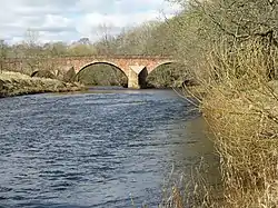
| |||
| Lochmaben Market Cross | 55°07′44″N 3°26′37″W | Category B | 37554 | 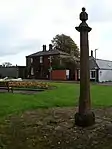
| |||
| St Mary Magdalene's Churchyard | 55°07′42″N 3°26′33″W | Category B | 37555 | Upload Photo | |||
| 9 Bruce Street including Oliver's Shop | 55°07′45″N 3°25′49″W | Category B | 37533 | Upload Photo | |||
| Woodfoot Farmhouse | 55°05′04″N 3°25′45″W | Category C(S) | 9967 | Upload Photo | |||
| Elshieshields Tower and adjoining House, Walled Garden and Gatepiers at South | 55°09′03″N 3°27′47″W | Category A | 9970 | Upload Photo | |||
| 41 High Street | 55°07′40″N 3°26′26″W | Category C(S) | 37546 | Upload Photo | |||
| High Street, Victoria House (Former Free Church Manse) | 55°07′37″N 3°26′24″W | Category C(S) | 37547 | Upload Photo | |||
| Heck Village Lake House and detached Outbuilding | 55°06′28″N 3°25′11″W | Category C(S) | 9948 | Upload Photo | |||
| High Street, Tolbooth including Iron Lamps | 55°07′44″N 3°26′30″W | Category A | 37541 | .jpg.webp)
| |||
| 17, 19 High Street | 55°07′43″N 3°26′29″W | Category C(S) | 37544 | Upload Photo | |||
| 21 High Street, Royal Bank Of Scotland | 55°07′43″N 3°26′29″W | Category C(S) | 37545 | Upload Photo | |||
| 12 (Kismet), 14 Bruce Street | 55°07′43″N 3°26′37″W | Category B | 37536 | Upload Photo | |||
| Bruce Street, Old Bank House | 55°07′43″N 3°26′38″W | Category B | 37537 | Upload Photo | |||
| Halleaths Home Farm, House and Steading | 55°07′38″N 3°25′08″W | Category B | 9944 | Upload Photo | |||
| Heck Village, Heck Hill Farm Steading Row to Roadside including Cottages | 55°06′27″N 3°25′07″W | Category C(S) | 9947 | Upload Photo | |||
| Kinnel Bridge, Todhillmuir Cottage | 55°09′05″N 3°25′49″W | Category C(S) | 9951 | .jpg.webp)
| |||
| Shaw Bridge | 55°09′46″N 3°26′52″W | Category B | 9956 | Upload Photo | |||
| Mayfield House and Outbuildings | 55°07′38″N 3°25′53″W | Category C(S) | 9953 | Upload Photo | |||
| 10 High Street, Dalveen | 55°07′44″N 3°26′28″W | Category C(S) | 37551 | Upload Photo | |||
| 6 Bruce Street. Former Manse and Walled Garden | 55°07′44″N 3°26′35″W | Category B | 37534 | Upload Photo | |||
| 8 Bruce Street, Crown Hotel | 55°07′43″N 3°26′36″W | Category C(S) | 37535 | Upload Photo | |||
| Spedlins Tower | 55°10′26″N 3°25′06″W | Category A | 9965 | .jpg.webp)
| |||
| Elshieshields Bridge | 55°09′09″N 3°27′50″W | Category B | 9969 | 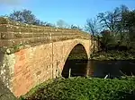
| |||
| Millhouse Bridge Village, Millhouse Bridge | 55°09′21″N 3°24′24″W | Category A | 9954 | Upload Photo | |||
| Moss-Side Cottages | 55°07′09″N 3°25′02″W | Category C(S) | 9955 | Upload Photo | |||
| High Street, Statue of Robert Bruce | 55°07′44″N 3°26′29″W | Category B | 37540 | 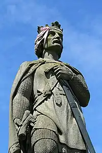
| |||
| 15 High Street, Kings Arms Hotel | 55°07′43″N 3°26′29″W | Category C(S) | 37543 | .jpg.webp)
| |||
| 14 High Street, Library and Freemason's Hall | 55°07′44″N 3°26′28″W | Category C(S) | 37552 | Upload Photo | |||
| Vendaceburn | 55°07′03″N 3°26′24″W | Category B | 9966 | Upload Photo | |||
| Halleaths former Stables (Houses and SSEB Stores and Workshops) | 55°07′37″N 3°25′02″W | Category A | 9971 | Upload Photo | |||
| Halleaths, Lodge at Innerfield | 55°07′26″N 3°25′09″W | Category B | 9973 | Upload Photo |
Key
The scheme for classifying buildings in Scotland is:
- Category A: "buildings of national or international importance, either architectural or historic; or fine, little-altered examples of some particular period, style or building type."[1]
- Category B: "buildings of regional or more than local importance; or major examples of some particular period, style or building type, which may have been altered."[1]
- Category C: "buildings of local importance; lesser examples of any period, style, or building type, as originally constructed or moderately altered; and simple traditional buildings which group well with other listed buildings."[1]
In March 2016 there were 47,288 listed buildings in Scotland. Of these, 8% were Category A, and 50% were Category B, with the remaining 42% being Category C.[2]
Notes
- Sometimes known as OSGB36, the grid reference (where provided) is based on the British national grid reference system used by the Ordnance Survey.
• "Guide to National Grid". Ordnance Survey. Retrieved 12 December 2007.
• "Get-a-map". Ordnance Survey. Retrieved 17 December 2007. - Historic Environment Scotland assign a unique alphanumeric identifier to each designated site in Scotland, for listed buildings this always begins with "LB", for example "LB12345".
References
- All entries, addresses and coordinates are based on data from Historic Scotland. This data falls under the Open Government Licence
- "What is Listing?". Historic Environment Scotland. Retrieved 29 May 2018.
- Scotland's Historic Environment Audit 2016 (PDF). Historic Environment Scotland and the Built Environment Forum Scotland. pp. 15–16. Retrieved 29 May 2018.
This article is issued from Wikipedia. The text is licensed under Creative Commons - Attribution - Sharealike. Additional terms may apply for the media files.