List of listed buildings in Kirkmabreck, Dumfries and Galloway
This is a list of listed buildings in the parish of Kirkmabreck, in Dumfries and Galloway, Scotland.
Wikimedia Commons has media related to Kirkmabreck.
List
| Name | Location | Date Listed | Grid Ref. [note 1] | Geo-coordinates | Notes | LB Number [note 2] | Image |
|---|---|---|---|---|---|---|---|
| Creetown, 63-65 And 67-69 St John Street | 54°54′00″N 4°22′45″W | Category C(S) | 13129 |  Upload Photo | |||
| Creetown, 26 St John Street | 54°54′02″N 4°22′46″W | Category C(S) | 13132 | Upload Photo | |||
| Kirkdale Bridge | 54°51′02″N 4°18′40″W | Category A | 13137 | Upload Photo | |||
| Kirkdale House And Sundial | 54°51′08″N 4°18′54″W | Category A | 13138 | 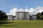
| |||
| Barholm Farm | 54°51′00″N 4°18′22″W | Category B | 10094 | Upload Photo | |||
| Creetown, High Street North, Kilbucho | 54°54′04″N 4°22′35″W | Category B | 10147 | Upload Photo | |||
| Creetown, Hill Of Burns, Gatepiers And Stable Courtyard | 54°53′58″N 4°22′35″W | Category B | 10149 | Upload Photo | |||
| Creetown ,Kirk Brae, Kirkmabreck Parish Church And Graveyard | 54°53′52″N 4°22′41″W | Category B | 10151 | 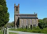
| |||
| Kirkdale Mausoleum And Kirkdale Kirk And Graveyard Walls | 54°51′33″N 4°19′10″W | Category A | 13139 | .jpg.webp)
| |||
| Kirkdale Steadings And Slaughterhouse | 54°51′18″N 4°19′05″W | Category A | 13140 | Upload Photo | |||
| Cassencaire House With Gatepiers And Walled Garden | 54°53′25″N 4°22′39″W | Category B | 10106 | Upload Photo | |||
| Creetown, 3 St John Street With Railings | 54°54′07″N 4°22′44″W | Category C(S) | 10153 | Upload Photo | |||
| Glen Farmhouse, With Stable Block | 54°53′42″N 4°16′02″W | Category B | 13136 | Upload Photo | |||
| Kirkmabreck Kirk | 54°52′50″N 4°21′05″W | Category B | 13142 | 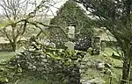
| |||
| Creetown ,Barholm Street, Bayview With Boundary Wall, Gate And Railings | 54°54′07″N 4°22′48″W | Category B | 10145 | Upload Photo | |||
| Creetown,13 St John Street | 54°54′06″N 4°22′44″W | Category C(S) | 13124 | Upload Photo | |||
| Creetown, Station Yard, Station | 54°54′39″N 4°22′45″W | Category B | 13134 | Upload Photo | |||
| Barholm Castle | 54°50′58″N 4°18′20″W | Category A | 10093 | 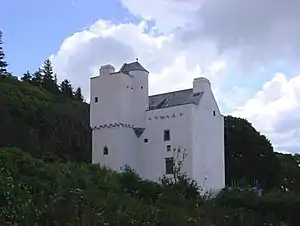
| |||
| Creetown, 2, 4 St John Street, Ellangowan Hotel | 54°54′04″N 4°22′46″W | Category B | 13131 | Upload Photo | |||
| Creetown, South Barholm Lodge | 54°54′07″N 4°22′54″W | Category B | 13133 | Upload Photo | |||
| Carsluith Castle And Adjoining Steadings | 54°51′34″N 4°20′48″W | Category A | 10104 | _elevation.jpg.webp)
| |||
| Creetown, Barholm Mains, Wickham Place (Former Stables) | 54°54′18″N 4°23′12″W | Category B | 10108 | Upload Photo | |||
| Creetown, 15 St John Street | 54°54′06″N 4°22′44″W | Category B | 13125 | Upload Photo | |||
| Creetown, 19 St John Street | 54°54′05″N 4°22′44″W | Category C(S) | 13127 | Upload Photo | |||
| Carsluith, Corn Mill And Round-Ended Barn | 54°51′56″N 4°21′12″W | Category B | 10105 | Upload Photo | |||
| Creetown, Crispin Street, St Crispins | 54°53′56″N 4°22′42″W | Category B | 10146 | Upload Photo | |||
| Creetown, Hill Of Burns Hotel And Sundial | 54°53′59″N 4°22′40″W | Category B | 10148 | Upload Photo | |||
| Glebe House | 54°52′49″N 4°22′26″W | Category B | 13135 | Upload Photo | |||
| Creetown, Hill Street, St Josephs Roman Catholic Church | 54°54′05″N 4°22′40″W | Category B | 10150 | Upload Photo | |||
| Creetown Moneypool Bridge | 54°54′11″N 4°22′47″W | Category C(S) | 10152 | Upload Photo | |||
| Creetown ,5 St John Street | 54°54′07″N 4°22′44″W | Category C(S) | 10154 | Upload Photo | |||
| Creetown, 7-9 St John Street | 54°54′07″N 4°22′44″W | Category C(S) | 10155 | Upload Photo | |||
| Creetown, 17 St John Street | 54°54′05″N 4°22′44″W | Category B | 13126 | Upload Photo | |||
| Creetown,59-61 St John Street, Cherry Trees And Stables | 54°54′00″N 4°22′44″W | Category C(S) | 13128 | Upload Photo | |||
| Creetown, 75 St John Street | 54°53′59″N 4°22′45″W | Category C(S) | 13130 | Upload Photo | |||
| Kirkdale Ice House | 54°50′59″N 4°18′44″W | Category C(S) | 13141 | Upload Photo | |||
| Carsluith, Bridge Cottage | 54°51′53″N 4°21′20″W | Category C(S) | 10095 | Upload Photo | |||
| Creetown, Adamson Square, Clocktower | 54°54′05″N 4°22′45″W | Category C(S) | 10107 | Upload Photo | |||
| 11 Creetown, St John Street | 54°54′06″N 4°22′44″W | Category B | 10156 | Upload Photo |
Key
The scheme for classifying buildings in Scotland is:
- Category A: "buildings of national or international importance, either architectural or historic; or fine, little-altered examples of some particular period, style or building type."[1]
- Category B: "buildings of regional or more than local importance; or major examples of some particular period, style or building type, which may have been altered."[1]
- Category C: "buildings of local importance; lesser examples of any period, style, or building type, as originally constructed or moderately altered; and simple traditional buildings which group well with other listed buildings."[1]
In March 2016 there were 47,288 listed buildings in Scotland. Of these, 8% were Category A, and 50% were Category B, with the remaining 42% being Category C.[2]
Notes
- Sometimes known as OSGB36, the grid reference (where provided) is based on the British national grid reference system used by the Ordnance Survey.
• "Guide to National Grid". Ordnance Survey. Retrieved 12 December 2007.
• "Get-a-map". Ordnance Survey. Retrieved 17 December 2007. - Historic Environment Scotland assign a unique alphanumeric identifier to each designated site in Scotland, for listed buildings this always begins with "LB", for example "LB12345".
References
- All entries, addresses and coordinates are based on data from Historic Scotland. This data falls under the Open Government Licence
- "What is Listing?". Historic Environment Scotland. Retrieved 29 May 2018.
- Scotland's Historic Environment Audit 2016 (PDF). Historic Environment Scotland and the Built Environment Forum Scotland. pp. 15–16. Retrieved 29 May 2018.
This article is issued from Wikipedia. The text is licensed under Creative Commons - Attribution - Sharealike. Additional terms may apply for the media files.