Central Luzon
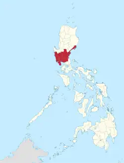
Central Luzon (Kapampangan: (Reyun ning) Kalibudtarang Luzon, Pangasinan: (Rehiyon na) Pegley na Luzon, Tagalog: (Rehiyon ng) Gitnang Luzon, Ilocano: (Rehion/Deppaar ti) Tengnga ti Luzon), designated as Region III, is an administrative region in the Philippines, primarily serving to organize the 7 provinces of the vast central plains of the island of Luzon (the largest island), for administrative convenience. The region contains the largest plain in the country and produces most of the country's rice supply, earning itself the nickname "Rice Granary of the Philippines".[1] Its provinces are: Aurora, Bataan, Bulacan, Nueva Ecija, Pampanga, Tarlac and Zambales.[5] Pangasinan was formerly a province of Central Luzon before President Marcos signed Presidential Decree No. 1, 1972, incorporating it into Ilocos Region. Additionally, the province of Aurora was part of the defunct political region Southern Tagalog when the region was divided into Calabarzon and Mimaropa, upon the issuance of Executive Order No. 103, dated May 17, 2002, by then-President Gloria Macapagal Arroyo, which transferred Aurora to Central Luzon.
Central Luzon
Region III | |
|---|---|
| Nickname: Rice Granary of the Philippines[1] | |
 Location in the Philippines | |
OpenStreetMap | |
| Coordinates: 15°28′N 120°45′E | |
| Country | |
| Island group | Luzon |
| Regional center | San Fernando (Pampanga)[2] |
| Largest city | San Jose del Monte |
| Area | |
| • Total | 22,014.63 km2 (8,499.90 sq mi) |
| Highest elevation | 2,037 m (6,683 ft) |
| Population (2020 census)[3] | |
| • Total | 12,422,172 |
| • Density | 560/km2 (1,500/sq mi) |
| Time zone | UTC+8 (PST) |
| ISO 3166 code | PH-03 |
| Provinces | |
| Independent Cities | |
| Component cities | |
| Municipalities | 115 |
| Barangays | 3,102 |
| Cong. districts | 20 |
| Languages | |
| GDP (2021) | ₱2 trillion $41 billion[4] |
| Growth rate | |
| HDI | |
| HDI rank | 4th in the Philippines (2019) |
Etymology
The current name of the region refers to its position on the island of Luzon. The term was coined by American colonialists after the defeat of the First Philippine Republic. There have been proposals to rename the current Central Luzon region into the Luzones region. The proposed name is in reference to the old name of Luzon island, Luções, which was later used to refer to the central area of the island, stretching from Pangasinan in the north, all the way to Pampanga in the south. The term Luções literally translates into Luzones.[6][7]
History
In 2002, Central Luzon had the highest unemployment rate among all regions in the country at 11.3%.[8]
Geography
The region is located north of Manila, the nation's capital. Central Luzon, in addition to the neighboring province of Pangasinan, contains the largest plain in the Philippines with its agricultural plains accounting for about 40% of the geographical region's area.[9] Bordering it are the regions of Ilocos and Cagayan Valley to the north; National Capital Region, Calabarzon and the waters of Manila Bay to the south; South China Sea to the west; and the Philippine Sea to the east.[10] Pangasinan is historico-culturally and geographically an integral part of this region, but was politically made part of the Ilocos Region by President Ferdinand Marcos on June 22, 1973.[11]
There are fifteen cities in the region: Balanga in Bataan; Baliwag, Malolos, Meycauayan, and San Jose del Monte in Bulacan; Cabanatuan, Gapan, Muñoz, Palayan, and San Jose in Nueva Ecija; Angeles City, Mabalacat, and San Fernando in Pampanga; Tarlac City in Tarlac; and Olongapo in Zambales. Central Luzon produces the most rice in the whole country. Excess rice is delivered and imported to other regions of the Philippines.[12]
The city of San Fernando, the provincial capital of Pampanga, is designated as the regional center. Aurora was transferred from Region IV through Executive Order No. 103 in May 2002.[13]
Administrative divisions

Provinces
Central Luzon comprises 7 provinces, 2 highly urbanized cities, 12 component cities, 116 municipalities, 3,102 barangays[14]
| Province or HUC | Capital | Population (2020)[3] | Area[15] | Density | Cities | Muni. | Barangay | |||||
|---|---|---|---|---|---|---|---|---|---|---|---|---|
| km2 | sq mi | /km2 | /sq mi | |||||||||
| Aurora | Baler | 1.9% | 235,750 | 3,133.40 | 1,209.81 | 75 | 190 | 0 | 8 | 151 | ||
| Bataan | Balanga | 6.9% | 853,373 | 1,372.98 | 530.11 | 620 | 1,600 | 1 | 11 | 237 | ||
| Bulacan | Malolos | 29.9% | 3,708,890 | 2,783.69 | 1,074.79 | 1,300 | 3,400 | 3 | 21 | 569 | ||
| Nueva Ecija | Palayan | 18.6% | 2,310,134 | 5,689.69 | 2,196.80 | 410 | 1,100 | 5 | 27 | 849 | ||
| Pampanga | San Fernando | 19.6% | 2,437,709 | 2,001.22 | 772.68 | 1,200 | 3,100 | 2 | 19 | 505 | ||
| Tarlac | Tarlac City | 12.1% | 1,503,456 | 3,053.60 | 1,179.00 | 490 | 1,300 | 1 | 17 | 511 | ||
| Zambales | Iba | 5.2% | 649,615 | 3,645.83 | 1,407.66 | 180 | 470 | 0 | 13 | 230 | ||
| Angeles City | † | — | 3.7% | 462,928 | 60.27 | 23.27 | 7,700 | 20,000 | — | — | 33 | |
| Olongapo | † | — | 2.1% | 260,317 | 185.00 | 71.43 | 1,400 | 3,600 | — | — | 17 | |
| Total | 12,422,172 | 22,014.63 | 8,499.90 | 560 | 1,500 | 14 | 116 | 3,102 | ||||
|
† Angeles and Olongapo are highly urbanized cities; figures are excluded from Pampanga and Zambales respectively. | ||||||||||||
Governors and vice governors
| Province | Image | Governor | Political Party | Vice Governor | |
|---|---|---|---|---|---|
 |
Christian M. Noveras | PDP–Laban | Gerardo A. Noveras | ||
 |
 |
Joet Garcia | NUP | Ma. Cristina M. Garcia | |
 |
 |
Daniel Fernando (Cesar Fernando Ramirez) |
NUP | Alex Castro | |
 |
 |
Aurelio Umali | Independent/Unang Sigaw | Emmanuel Antonio Umali | |
 |
 |
Dennis Pineda | NPC/KAMBILAN | Lilia G. Pineda | |
 |
 |
Susan Yap | NPC | Carlito S. David | |
 |
 |
Hermogenes E. Ebdane, Jr. | SZP | Jacqueline Rose Khonghun | |
Cities
The Central Luzon Region has fifteen cities. San Jose del Monte is the city with the most population while Angeles City is the most densely populated city in the region. Tarlac City is the largest based on land area.
- † Regional center
| City | Population (2020)[3] | Area[16] | Density | City class | Income class | Province | ||
|---|---|---|---|---|---|---|---|---|
| Angeles City | 462,928 | 60.27 | 23.27 | 7,700 | 20,000 | Highly Urbanized | 1st | Pampanga |
| Balanga | 104,173 | 111.63 | 43.10 | 930 | 2,400 | Component | 4th | Bataan |
| Baliwag | 168,470 | 45.05 | 17.39 | 3,700 | 9,600 | Component | 2nd | Bulacan |
| Cabanatuan | 327,325 | 192.29 | 74.24 | 1,700 | 4,400 | Component | 1st | Nueva Ecija |
| Gapan | 122,968 | 164.44 | 63.49 | 750 | 1,900 | Component | 4th | Nueva Ecija |
| Mabalacat | 293,244 | 83.18 | 32.12 | 3,500 | 9,100 | Component | 1st | Pampanga |
| Malolos | 261,189 | 67.25 | 25.97 | 3,900 | 10,000 | Component | 1st | Bulacan |
| Meycauayan | 225,673 | 32.10 | 12.39 | 7,000 | 18,000 | Component | 1st | Bulacan |
| Muñoz | 84,308 | 163.05 | 62.95 | 520 | 1,300 | Component | 4th | Nueva Ecija |
| Olongapo | 260,317 | 185.00 | 71.43 | 1,400 | 3,600 | Highly Urbanized | 1st | Zambales |
| Palayan | 45,383 | 101.40 | 39.15 | 450 | 1,200 | Component | 5th | Nueva Ecija |
| † San Fernando | 354,666 | 67.74 | 26.15 | 5,200 | 13,000 | Component | 1st | Pampanga |
| San Jose | 150,917 | 185.99 | 71.81 | 810 | 2,100 | Component | 3rd | Nueva Ecija |
| San Jose del Monte | 651,813 | 105.53 | 40.75 | 6,200 | 16,000 | Component | 1st | Bulacan |
| Tarlac City | 385,398 | 274.66 | 106.05 | 1,400 | 3,600 | Component | 1st | Tarlac |
Demographics
| Year | Pop. | ±% p.a. |
|---|---|---|
| 1903 | 819,768 | — |
| 1918 | 1,044,631 | +1.63% |
| 1939 | 1,586,524 | +2.01% |
| 1948 | 1,860,274 | +1.78% |
| 1960 | 2,568,206 | +2.72% |
| 1970 | 3,695,955 | +3.70% |
| 1975 | 4,300,196 | +3.08% |
| 1980 | 4,909,938 | +2.69% |
| 1990 | 6,338,590 | +2.59% |
| 1995 | 7,092,191 | +2.13% |
| 2000 | 8,204,742 | +3.17% |
| 2007 | 9,709,177 | +2.35% |
| 2010 | 10,137,737 | +1.58% |
| 2015 | 11,218,177 | +1.95% |
| 2020 | 12,422,172 | +2.02% |
| Source: Philippine Statistics Authority[17][18] | ||
Languages
The native languages of Central Luzon are:
- Bugkalot, spoken in parts of Nueva Ecija and Aurora.
- Kapampangan, spoken in the entirety of Pampanga and southern Tarlac, as well as southeastern Zambales, northeastern Bataan, western Bulacan, and southwestern Nueva Ecija.
- Casiguranin (Kasiguranin), spoken in parts of Aurora.
- Pangasinan, spoken in northern Tarlac, northeastern Zambales, and northwestern Nueva Ecija.
- Tagalog, spoken in Bulacan, Pampanga, Tarlac, Nueva Ecija, Aurora, Bataan, and Zambales. The most popular Tagalog dialect is in Bulacan which is also heard in Nueva Ecija; the Tagalog dialect spoken in Aurora is basically similar to Tayabas Tagalog of Quezon, President Manuel L. Quezon who is considered the Father of National Language because he chose Tagalog as the basis of national language was born and raised in Baler, Aurora. It is the regional lingua franca, mostly as Filipino.
- Ilocano, spoken in northern Nueva Ecija, north Tarlac, north Aurora, and some parts of Zambales. It is the main lingua franca in the northern areas.
- Sambal, spoken in a majority of Zambales and a few scattered areas in Bataan and Pampanga.
Religion
Eighty percent of the population of Central Luzon is Roman Catholic. Other religions represented are Protestants (including Evangelicals), Islam, Iglesia ni Cristo comprised significant 5% adherence and Pampanga is the first ecclesiastical district of the Church , and indigenous Philippine folk religions. There are also other denominations such as Jesus Is Lord, Pentecostal Missionary Church of Christ, Ang Dating Daan, Jesus Miracle Crusade, United Methodist Church and others.
Economy
References
- Edenhofer, Ottmar; Wallacher, Johannes; Lotze-Campen, Hermann; Reder, Michael; Knopf, Brigitte; Müller, Johannes (June 25, 2012). Climate Change, Justice and Sustainability: Linking Climate and Development Policy. Springer Science & Business Media. p. 206. ISBN 9789400745407.
- "DILG Region 3 - Regional Management". Department of the Interior and Local Government. Retrieved May 29, 2016.
- Census of Population (2020). "Region III (Central Luzon)". Total Population by Province, City, Municipality and Barangay. Philippine Statistics Authority. Retrieved July 8, 2021.
- "Gross Regional Domestic Product". openstat.psa.gov.ph. Philippine Statistics Authority. Retrieved May 20, 2021.
- "Central Luzon, Region III, Philippines". flagspot.net.
- "Change in name will be good for Philippines". July 15, 2016.
- "Should the Philippines be renamed? Historian weighs in". ABS-CBN Corporation. June 13, 2017. Archived from the original on April 6, 2023.
- Isip, Rendy (June 3, 2002). "Region 3 has highest unemployment rate". Manila Standard. Angeles City: Kamahalan Publishing Corp. p. 5. Retrieved February 6, 2022.
- "Region 3 Profile, Philippines". August 17, 2020.
- "Region III, Central Luzon, Geographical Location". evis.net.ph.
- "Presidential Decree № 224". Retrieved November 5, 2016.
- "REGION III (Central Luzon)". National Statistical Coordination Board. Archived from the original on November 14, 2012. Retrieved September 7, 2016.
- "Executive Order No. 103; Dividing Region IV into Region IV-A and Region IV-B, Transferring the Province of Aurora to Region III and for Other Purposes". Philippine Statistics Authority. May 17, 2002. Archived from the original on May 18, 2016. Retrieved March 29, 2016.
SECTION 4. The Province of Aurora is hereby transferred to and shall form part of Region III.
- "List of Regions". National Statistical Coordination Board. Archived from the original on October 13, 2008. Retrieved January 9, 2011.
- "PSGC Interactive; List of Provinces". Philippine Statistics Authority. Archived from the original on January 11, 2013. Retrieved March 29, 2016.
- "PSGC Interactive; List of Cities". Philippine Statistics Authority. Archived from the original on April 29, 2011. Retrieved March 29, 2016.
- "Population and Annual Growth Rates for The Philippines and Its Regions, Provinces, and Highly Urbanized Cities" (PDF). 2010 Census and Housing Population. Philippine Statistics Authority. Archived from the original (PDF) on September 28, 2013. Retrieved August 9, 2013.
- Census of Population (2015). "Region III (Central Luzon)". Total Population by Province, City, Municipality and Barangay. Philippine Statistics Authority. Retrieved June 20, 2016.
- "Poverty incidence (PI):". Philippine Statistics Authority. Retrieved December 28, 2020.
- "Estimation of Local Poverty in the Philippines" (PDF). Philippine Statistics Authority. November 29, 2005.
- "2009 Official Poverty Statistics of the Philippines" (PDF). Philippine Statistics Authority. February 8, 2011.
- "Annual Per Capita Poverty Threshold, Poverty Incidence and Magnitude of Poor Population, by Region and Province: 1991, 2006, 2009, 2012 and 2015". Philippine Statistics Authority. August 27, 2016.
- "Annual Per Capita Poverty Threshold, Poverty Incidence and Magnitude of Poor Population, by Region and Province: 1991, 2006, 2009, 2012 and 2015". Philippine Statistics Authority. August 27, 2016.
- "Annual Per Capita Poverty Threshold, Poverty Incidence and Magnitude of Poor Population, by Region and Province: 1991, 2006, 2009, 2012 and 2015". Philippine Statistics Authority. August 27, 2016.
- "Updated Annual Per Capita Poverty Threshold, Poverty Incidence and Magnitude of Poor Population with Measures of Precision, by Region and Province: 2015 and 2018". Philippine Statistics Authority. June 4, 2020.

.jpg.webp)

.jpg.webp)


