Minjavan District
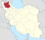
Minjavan District (Persian: بخش منجوان) is in Khoda Afarin County, East Azerbaijan province, Iran.
Minjavan District
Persian: بخش منجوان | |
|---|---|
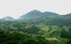 Wheat farms near Asheqlu | |
 Minjavan District | |
| Coordinates: 38°57′15″N 46°44′30″E[1] | |
| Country | |
| Province | East Azerbaijan |
| County | Khoda Afarin |
| Population (2016)[2] | |
| • Total | 11,920 |
| Time zone | UTC+3:30 (IRST) |
At the 2006 National Census, its population (as parts of the former Khoda Afarin District of Kaleybar County) was 12,993 in 2,948 households.[3] The following census in 2011 counted 12,524 people in 3,388 households,[4] by which time Khoda Afarin District had been elevated to the status of a county and divided into three districts.[5] At the latest census in 2016, the district had 11,920 inhabitants in 3,864 households.[2]
The online edition of the Dehkhoda Dictionary, quoting Iranian Army files,[6] reports a population of 8,464 people in the late 1940s.[7] At that time Janan Lu, Asheqlu, Dash Bashi, and Setan were the most important villages of the district. There are 22 villages which are no longer populated.[8]
History
The only noteworthy allusion to the district in official records relates to an appeal by the inhabitants of the district to the interior minister of Iran, requesting protection from the abuses by Mohammad Khanlu family.'.[9]
The district was formed in December 2010 by the approval of the Iranian government.[10]
| Administrative Divisions | 2006[4] | 2011[4] | 2016[2] |
|---|---|---|---|
| Dizmar-e Sharqi Rural District | 2,888 | 3,097 | 2,760 |
| Minjavan-e Gharbi Rural District | 4,378 | 4,214 | 4,094 |
| Minjavan-e Sharqi Rural District | 5,727 | 5,213 | 5,066 |
| Total | 12,993 | 12,524 | 11,920 |
| 1As a part of Kaleybar County at the 2006 census | |||
References
- OpenStreetMap contributors (3 April 2023). "Minjavan District (Khoda Afarin County)" (Map). OpenStreetMap. Retrieved 3 April 2023.
- "Census of the Islamic Republic of Iran, 1395 (2016)". AMAR (in Persian). The Statistical Center of Iran. p. 03. Archived from the original (Excel) on 13 November 2020. Retrieved 19 December 2022.
- "Census of the Islamic Republic of Iran, 1385 (2006)". AMAR (in Persian). The Statistical Center of Iran. p. 03. Archived from the original (Excel) on 20 September 2011. Retrieved 25 September 2022.
- "Census of the Islamic Republic of Iran, 1390 (2011)" (Excel). Iran Data Portal (in Persian). The Statistical Center of Iran. p. 03. Retrieved 19 December 2022.
- "Letter of approval regarding country divisions in Kalibar county, approved 09/07/1389". Qavanin (in Persian). 7 September 1389. Retrieved 18 February 2023.
- فرهنگ جغرافیایی ایران، آبادیها، زیر نظر حسینعلی رزم آرا، تهران: سازمان جغرافیایی کشور، 1329، ج 4 ص ۲۰۴
- "Archived copy". Archived from the original on 6 March 2014. Retrieved 11 March 2014.
{{cite web}}: CS1 maint: archived copy as title (link) - "روستانت - بخش منجوان". Archived from the original on 22 December 2015. Retrieved 5 March 2014.
- "نامه اهالی منجوان [از دهستانهای تبریز] به مجلس شورایملی در خصوص شکایت از عب... -". Archived from the original on 6 March 2014. Retrieved 5 March 2014.
- "The government information base was created in Khodaafrin county in East Azarbaijan province" (in Persian). Archived from the original on 6 March 2014. Retrieved 18 February 2023.
| Capital | |||||||||||||||||||||||||||||||
|---|---|---|---|---|---|---|---|---|---|---|---|---|---|---|---|---|---|---|---|---|---|---|---|---|---|---|---|---|---|---|---|
| Districts |
| ||||||||||||||||||||||||||||||