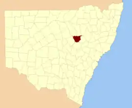
Gowen County

Gowen County is one of the 141 Cadastral divisions of New South Wales. It is located to the east of the Castlereagh River in the area to the east of Gilgandra, to Coonabarabran in the north-east. This includes land on both sides of the Newell Highway.

Gowen
New South Wales
Location in New South Wales
Lands administrative divisions around Gowen:
Leichhardt Baradine White
Ewenmar Gowen Napier
Ewenmar Lincoln Napier

The origin of the name Gowen County is unknown.[1]

Parishes within this county

A full list of parishes found within this county; their current LGA and mapping coordinates to the approximate centre of each location is as follows:

ParishLGACoordinates
BabyWarrumbungle Shire31°17′54″S 149°30′04″E
BalumbridalWarrumbungle Shire31°20′54″S 149°09′04″E
BandullaWarrumbungle Shire31°43′54″S 149°08′04″E
BearbongGilgandra Shire31°38′54″S 148°57′04″E
BelarWarrumbungle Shire31°29′54″S 149°15′04″E
BiralbungGilgandra Shire31°38′54″S 148°48′04″E
Bone BoneWarrumbungle Shire31°35′54″S 149°10′04″E
BoybenGilgandra Shire31°46′54″S 148°52′04″E
BreelongGilgandra Shire31°44′54″S 148°48′04″E
BurrendahGilgandra Shire31°42′54″S 148°55′04″E
CaiganWarrumbungle Shire31°41′54″S 149°14′04″E
CallangoanGilgandra Shire31°29′54″S 148°36′04″E
CaraghnanCoonamble Shire31°17′54″S 149°01′04″E
CobbinbilCoonamble Shire31°18′54″S 148°39′04″E
CoonabarabranWarrumbungle Shire31°15′54″S 149°16′04″E
CuttabullooWarrumbungle Shire31°38′54″S 149°18′04″E
DeringullaWarrumbungle Shire31°20′54″S 149°14′04″E
DillyGilgandra Shire31°31′54″S 148°54′04″E
EringanerinGilgandra Shire31°41′54″S 148°42′04″E
GowangWarrumbungle Shire31°22′54″S 149°01′04″E
GreenbahWarrumbungle Shire31°33′54″S 149°19′04″E
GulargamboneCoonamble Shire31°23′54″S 148°14′04″E
GuminCoonamble Shire31°17′54″S 148°53′04″E
GundiWarrumbungle Shire31°17′54″S 149°11′04″E
KirbanGilgandra Shire31°31′54″S 149°04′04″E
MundarGilgandra Shire31°31′54″S 148°48′04″E
NamanCoonamble Shire31°20′54″S 149°00′04″E
NandiWarrumbungle Shire31°14′54″S 149°13′04″E
OrandelbiniaWarrumbungle Shire31°32′54″S 149°11′04″E
PiangulaGilgandra Shire31°38′54″S 149°02′04″E
PibbonGilgandra Shire31°34′54″S 149°04′04″E
QuandongCoonamble Shire31°18′54″S 148°46′04″E
TannabarWarrumbungle Shire31°23′54″S 149°09′04″E
TarambijalCoonamble Shire31°21′54″S 148°44′04″E
TerrabileGilgandra Shire31°31′54″S 148°42′04″E
TimorWarrumbungle Shire31°16′54″S 149°07′04″E
TonderburineCoonamble Shire31°21′54″S 148°52′04″E
TooraweenahGilgandra Shire31°27′54″S 148°54′04″E
UargonGilgandra Shire31°29′54″S 149°00′04″E
UlamambriWarrumbungle Shire31°14′54″S 149°30′04″E
UlungraGilgandra Shire31°43′54″S 149°02′04″E
UrabribleWarrumbungle Shire31°19′54″S 149°17′04″E
WallumburrawangGilgandra Shire31°33′54″S 149°00′04″E
WilberCoonamble Shire31°17′54″S 148°33′04″E
WindurongGilgandra Shire31°27′54″S 148°40′04″E
WingabuttaWarrumbungle Shire31°29′54″S 149°11′04″E
WoorutWarrumbungle Shire31°18′54″S 149°04′04″E
YalcogrinGilgandra Shire31°37′54″S 148°41′04″E
YarragrinWarrumbungle Shire31°40′54″S 149°08′04″E
YarrawinWarrumbungle Shire31°24′54″S 149°15′04″E
YoulbungGilgandra Shire31°27′54″S 148°51′04″E

References

  1. "Gowen". Geographical Names Register (GNR) of NSW. Geographical Names Board of New South Wales. Retrieved 30 July 2013.
This article is issued from Wikipedia. The text is licensed under Creative Commons - Attribution - Sharealike. Additional terms may apply for the media files.