National Register of Historic Places listings in Lewis County, New York
List of the National Register of Historic Places listings in Lewis County, New York

Location of Lewis County in New York
This is intended to be a complete list of properties and districts listed on the National Register of Historic Places in Lewis County, New York. The locations of National Register properties and districts (at least for all showing latitude and longitude coordinates below) may be seen in a map by clicking on "Map of all coordinates".[1] One property, the Franklin B. Hough House, is further designated a National Historic Landmark.
This National Park Service list is complete through NPS recent listings posted October 20, 2023.[2]
| Albany (Albany) – Allegany – Bronx – Broome – Cattaraugus – Cayuga – Chautauqua – Chemung – Chenango – Clinton – Columbia – Cortland – Delaware – Dutchess (Poughkeepsie, Rhinebeck) – Erie (Buffalo) – Essex – Franklin – Fulton – Genesee – Greene – Hamilton – Herkimer – Jefferson – Kings – Lewis – Livingston – Madison – Monroe (Rochester) – Montgomery – Nassau – New York (Below 14th Street, 14th to 59th Streets, 59th to 110th Streets, Above 110th Street, Islands) – Niagara (Niagara Falls) – Oneida – Onondaga (Syracuse) – Ontario – Orange – Orleans – Oswego – Otsego – Putnam – Queens – Rensselaer – Richmond – Rockland – St. Lawrence – Saratoga – Schenectady – Schoharie – Schuyler – Seneca – Steuben – Suffolk – Sullivan – Tioga – Tompkins – Ulster – Warren – Washington – Wayne – Westchester (Northern, Southern, New Rochelle, Peekskill, Yonkers) – Wyoming – Yates |
Listings county-wide
| [3] | Name on the Register | Image | Date listed[4] | Location | City or town | Description |
|---|---|---|---|---|---|---|
| 1 | Alpina Archeological District | _ELEVATION%252C_VIEW_LOOKING_WEST._-_Alpina_Iron_Furnace%252C_At_head_of_Bonaparte_Creek%252C_Harrisville%252C_Lewis_County%252C_NY_HAER_NY%252C25-HARV%252C1-1.tif.jpg.webp) Alpina Archeological District |
November 2, 1995 (#95000068) |
Fort Drum |
Diana | Rural iron furnace and associated village site |
| 2 | Basselin House | February 8, 2022 (#100007408) |
9757 NY 812 43°53′34″N 75°23′31″W |
Croghan | ||
| 3 | Bateman Hotel | 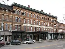 Bateman Hotel |
February 18, 1994 (#94000046) |
7574 S. State St. 43°47′10″N 75°29′31″W |
Lowville | |
| 4 | Beaver Falls Grange Hall No. 554 | December 1, 2015 (#15000852) |
9577 Main St. 43°53′08″N 75°25′52″W |
Beaver Falls | 1892 building was education and entertainment center in small agricultural community | |
| 5 | Jonathan C. Collins House and Cemetery | 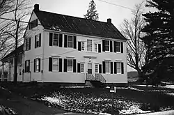 Jonathan C. Collins House and Cemetery |
November 9, 1988 (#88002137) |
West Rd. 43°34′07″N 75°25′14″W |
Constableville | |
| 6 | Collinsville Cemetery | .tif.jpg.webp) Collinsville Cemetery |
May 7, 2014 (#14000192) |
4061 East Rd. 43°37′35″N 75°23′46″W |
West Turin vicinity | |
| 7 | Constable Hall | 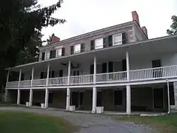 Constable Hall |
March 7, 1973 (#73001197) |
Off NY 26 43°33′43″N 75°25′24″W |
Constableville | |
| 8 | Constableville Village Historic District | 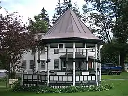 Constableville Village Historic District |
September 15, 1983 (#83001703) |
Roughly bounded by Sugar River, Main, N. Main, W. Main, Church, High, West and James Sts. 43°33′51″N 75°25′50″W |
Constableville | |
| 9 | Croghan Island Mill | 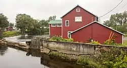 Croghan Island Mill |
July 30, 2010 (#10000515) |
9897 S. Bridge St. 43°53′52″N 75°23′37″W |
Croghan vicinity | |
| 10 | First Lewis County Clerk's Office | October 27, 2017 (#100001769) |
6660 NY 26 43°44′12″N 75°28′09″W |
Martinsburg | ||
| 11 | Forest Presbyterian Church | September 24, 2004 (#04001060) |
4109 Center St. 43°37′05″N 75°21′41″W |
Lyons Falls | ||
| 12 | Gould Mansion Complex | 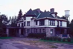 Gould Mansion Complex |
April 19, 1978 (#78001857) |
Main St. 43°37′05″N 75°21′38″W |
Lyons Falls | |
| 13 | Franklin B. Hough House | 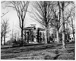 Franklin B. Hough House |
October 15, 1966 (#66000526) |
Collins St. 43°47′22″N 75°29′50″W |
Lowville | |
| 14 | Lewis County Fairgrounds | February 14, 2002 (#02000006) |
Bostwick St. 43°47′43″N 75°29′25″W |
Lowville | ||
| 15 | Lewis County Soldiers' and Sailors' Monument | 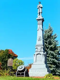 Lewis County Soldiers' and Sailors' Monument |
July 29, 2009 (#09000575) |
Village Green, NY 26 and Bostwick Sts. 43°47′27″N 75°29′44″W |
Lowville | |
| 16 | Harry and Molly Lewis House | 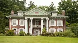 Harry and Molly Lewis House |
November 21, 2012 (#12000956) |
9520 E. Main St. 43°53′06″N 75°25′39″W |
Beaver Falls vicinity | |
| 17 | Lewisburg Archeological District | _ELEVATION%252C_WITH_SOUTH_WALL_OF_WHEEL_PIT_IN_FOREGROUND%252C_LOOKING_SOUTH._-_Lewisburg_Furnace%252C_One_Indian_River%252C_Harrisville%252C_Lewis_County%252C_NY_HAER_NY%252C25-HARV.V%252C1-5.tif.jpg.webp) Lewisburg Archeological District |
November 2, 1995 (#95000071) |
Fort Drum |
Diana | Rural iron furnace and associated village site |
| 18 | Leyden Common School No. 2 | June 21, 2016 (#16000392) |
6606 School Rd. 43°32′02″N 75°22′02″W |
Talcottville | 1870 one-room schoolhouse in use for almost a century afterward | |
| 19 | Lowville Masonic Temple | 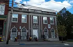 Lowville Masonic Temple |
September 19, 2008 (#08000919) |
7552 S. State St. 43°47′10″N 75°29′28″W |
Lowville | |
| 20 | Lowville Presbyterian Church | 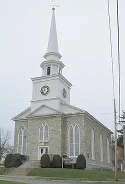 Lowville Presbyterian Church |
June 27, 2007 (#07000623) |
7707 North State St. 43°47′28″N 75°29′47″W |
Lowville | |
| 21 | Gen. Walter Martin House | July 24, 2008 (#08000698) |
6575 Main St. 43°44′16″N 75°28′09″W |
Martinsburg | ||
| 22 | Martinsburg Common School District #4 | November 10, 2022 (#100008340) |
6503 Ramos Rd. 43°45′54″N 75°27′42″W |
Martinsburg | ||
| 23 | Martinsburg Town Hall | 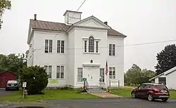 Martinsburg Town Hall |
March 21, 2001 (#01000241) |
NY 26 Main St., E 43°44′14″N 75°28′08″W |
Martinsburg | |
| 24 | Methodist Episcopal Church of West Martinsburg | 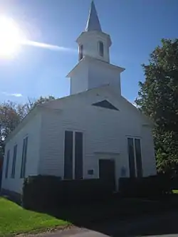 Methodist Episcopal Church of West Martinsburg |
September 15, 1983 (#83001704) |
W. Martinsburg Rd. 43°45′35″N 75°31′00″W |
West Martinsburg | |
| 25 | Moser Farm | July 30, 2010 (#10000516) |
8778 Erie Canal Rd. 43°53′32″N 75°20′06″W |
Kirschnerville vicinity | ||
| 26 | Old Lowville Cemetery | August 22, 2016 (#16000553) |
5515 Jackson and 5575 River Sts. 43°47′00″N 75°29′12″W |
Lowville | One of the oldest cemeteries in the county holds the graves of many early Lowville settlers and war veterans | |
| 27 | Osceola Town Hall | 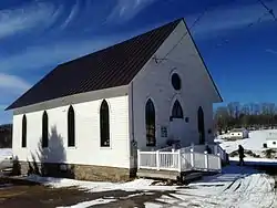 Osceola Town Hall |
December 22, 2005 (#05001454) |
N. Ocseola Rd. 43°30′11″N 75°43′21″W |
Osceola | |
| 28 | Pinckney Corners Cemetery | September 10, 2014 (#14000578) |
Pinckney Rd. 43°52′03″N 75°43′29″W |
Copenhagen vicinity. | Graves in town's oldest cemetery date back to 1810; those buried include veterans of Revolutionary War and War of 1812 | |
| 29 | Pine Grove Community Church | 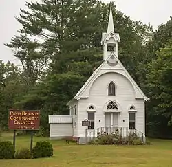 Pine Grove Community Church |
August 20, 2009 (#09000633) |
Austin Rd. & Pine Grove Rd. 43°45′07″N 75°22′39″W |
Pine Grove | |
| 30 | The Pines | June 27, 2007 (#07000621) |
3998-4000 Lyons Falls Rd. 43°37′23″N 75°21′32″W |
Lyons Falls | ||
| 31 | St. Mark's Church | August 6, 1998 (#98001003) |
Jct. of West Main and Elm Sts. 43°34′52″N 75°20′59″W |
Port Leyden | ||
| 32 | Stoddard–O'Connor House | June 23, 2011 (#11000402) |
5431 Shady Ave. 43°47′14″N 75°29′20″W |
Lowville | ||
| 33 | Talcottville Cemetery | December 8, 2017 (#100001885) |
2052 NY 12-D 43°31′51″N 75°21′51″W |
Talcottville | ||
| 34 | Wildwood Cemetery and Mary Lyon Fisher Memorial Chapel | June 27, 2011 (#11000403) |
River Rd. 43°36′30″N 75°20′43″W |
Lyons Falls | ||
| 35 | Edmund Wilson House | 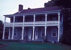 Edmund Wilson House |
November 26, 1973 (#73001198) |
Rte. 12d, Talcottville,NY 43°32′05″N 75°21′59″W |
Talcottville |
See also
Wikimedia Commons has media related to National Register of Historic Places in Lewis County, New York.
References
- The latitude and longitude information provided in this table was derived originally from the National Register Information System, which has been found to be fairly accurate for about 99% of listings. Some locations in this table may have been corrected to current GPS standards.
- National Park Service, United States Department of the Interior, "National Register of Historic Places: Weekly List Actions", retrieved October 20, 2023.
- Numbers represent an alphabetical ordering by significant words. Various colorings, defined here, differentiate National Historic Landmarks and historic districts from other NRHP buildings, structures, sites or objects.
- The eight-digit number below each date is the number assigned to each location in the National Register Information System database, which can be viewed by clicking the number.

This article is issued from Wikipedia. The text is licensed under Creative Commons - Attribution - Sharealike. Additional terms may apply for the media files.