National Register of Historic Places listings in Schenectady County, New York
List of the National Register of Historic Places listings in Schenectady County, New York

Location of Schenectady County in New York
This is intended to be a complete list of properties and districts listed on the National Register of Historic Places in Schenectady County, New York. The locations of National Register properties and districts (at least for all showing latitude and longitude coordinates below) may be seen in a map by clicking on "Map of all coordinates".[1] Four of the sites are further designated U.S. National Historic Landmarks.
This National Park Service list is complete through NPS recent listings posted October 20, 2023.[2]
| Albany (Albany) – Allegany – Bronx – Broome – Cattaraugus – Cayuga – Chautauqua – Chemung – Chenango – Clinton – Columbia – Cortland – Delaware – Dutchess (Poughkeepsie, Rhinebeck) – Erie (Buffalo) – Essex – Franklin – Fulton – Genesee – Greene – Hamilton – Herkimer – Jefferson – Kings – Lewis – Livingston – Madison – Monroe (Rochester) – Montgomery – Nassau – New York (Below 14th Street, 14th to 59th Streets, 59th to 110th Streets, Above 110th Street, Islands) – Niagara (Niagara Falls) – Oneida – Onondaga (Syracuse) – Ontario – Orange – Orleans – Oswego – Otsego – Putnam – Queens – Rensselaer – Richmond – Rockland – St. Lawrence – Saratoga – Schenectady – Schoharie – Schuyler – Seneca – Steuben – Suffolk – Sullivan – Tioga – Tompkins – Ulster – Warren – Washington – Wayne – Westchester (Northern, Southern, New Rochelle, Peekskill, Yonkers) – Wyoming – Yates |
Listings county-wide
| [3] | Name on the Register | Image | Date listed[4] | Location | City or town | Description |
|---|---|---|---|---|---|---|
| 1 | Abrahams Farmhouse | October 11, 1984 (#84003092) |
Hardin Rd. 42°48′30″N 74°11′25″W |
Duanesburg | ||
| 2 | Alexandra Apartment Hotel | August 8, 2019 (#100004246) |
1-3 State Street 42°48′55″N 73°56′57″W |
Schenectady | 1900 long-term residence built in Queen Anne Style for workers at nearby GE facility | |
| 3 | Avery Farmhouse | October 11, 1984 (#84003106) |
NY 30 42°46′11″N 74°14′00″W |
Duanesburg | ||
| 4 | H. S. Barney Building | July 19, 1984 (#84002965) |
217-229 State St. 42°48′55″N 73°56′44″W |
Schenectady | ||
| 5 | Becker Farmhouse | October 11, 1984 (#84003114) |
Creek Rd. 42°45′07″N 74°15′43″W |
Duanesburg | ||
| 6 | Bishop Family Lustron House | March 6, 2008 (#08000144) |
26 Slater Dr. 42°53′20″N 73°54′52″W |
Glenville | ||
| 7 | Joseph Braman House | 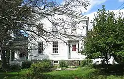 Joseph Braman House |
April 24, 1987 (#87000917) |
Braman's Corners 42°48′31″N 74°13′10″W |
Duanesburg | |
| 8 | Brandywine Avenue School | December 9, 1999 (#99001491) |
108 Brandywine Ave. 42°48′08″N 73°55′29″W |
Schenectady | Destroyed by fire in November 2007 | |
| 9 | George Washington Carver Community Center | October 16, 2020 (#100005677) |
700 Craig St. 42°48′09″N 73°56′16″W |
Schenectady | ||
| 10 | Central Fire Station | April 11, 1985 (#85000729) |
Erie Blvd. 42°48′48″N 73°56′47″W |
Schenectady | ||
| 11 | Chadwick Farmhouse | October 11, 1984 (#84003175) |
Schoharie Tpk. 42°44′17″N 74°10′16″W |
Duanesburg | ||
| 12 | Chapman Farmhouse | 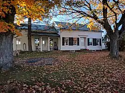 Chapman Farmhouse |
October 11, 1984 (#84003176) |
Miller's Corners Rd. 42°48′44″N 74°13′16″W |
Duanesburg | |
| 13 | Christ Episcopal Church | 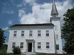 Christ Episcopal Church |
April 24, 1987 (#87000911) |
NY 20 42°46′07″N 74°09′17″W |
Duanesburg | |
| 14 | Christman Bird and Wildlife Sanctuary | 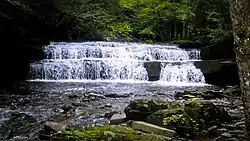 Christman Bird and Wildlife Sanctuary |
August 25, 1970 (#70000433) |
Schoharie Tpke. 42°44′27″N 74°07′30″W |
Delanson | |
| 15 | Clark Witbeck Co. Warehouse | July 31, 2023 (#100009168) |
132-136 Broadway 42°48′50″N 73°56′32″W |
Schenectady | ||
| 16 | Delanson Historic District | 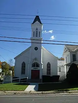 Delanson Historic District |
October 11, 1984 (#84003181) |
Main St. 42°44′35″N 74°11′16″W |
Delanson | |
| 17 | Dellemont-Wemple Farm | October 25, 1973 (#73001266) |
W of Schenectady on Wemple Rd. 42°46′16″N 74°00′30″W |
Rotterdam | ||
| 18 | Duane Mansion | 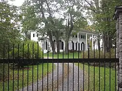 Duane Mansion |
April 24, 1987 (#87000910) |
NY 20 42°45′16″N 74°07′41″W |
Duanesburg | |
| 19 | Duanesburg-Florida Baptist Church | October 11, 1984 (#84003185) |
NY 30 42°48′31″N 74°12′58″W |
Duanesburg | ||
| 20 | Eatons Corners Historic District | October 11, 1984 (#84003196) |
Eatons Corners Rd. 42°48′21″N 74°14′50″W |
Duanesburg | ||
| 21 | Elmer Avenue School | November 21, 2022 (#100008387) |
90 Elmer Ave. 42°48′37″N 73°55′17″W |
Schenectady | ||
| 22 | Enlarged Double Lock No. 23, Old Erie Canal | 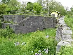 Enlarged Double Lock No. 23, Old Erie Canal |
March 6, 2008 (#08000145) |
Rice Rd. 42°49′25″N 73°59′13″W |
Rotterdam | |
| 23 | Ferguson Farm Complex | 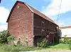 Ferguson Farm Complex |
April 24, 1987 (#87000913) |
NY 20 42°45′37″N 74°06′56″W |
Duanesburg | |
| 24 | First Unitarian Society Church | 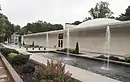 First Unitarian Society Church |
February 5, 2014 (#13001157) |
1221 Wendell Ave. 42°48′57″N 73°55′28″W |
Schenectady | Modernist Edward Durrell Stone church in GE Realty Plot district |
| 25 | Fitzgerald Building | May 19, 2021 (#100006517) |
144-148 Clinton St. 42°48′45″N 73°56′24″W |
Schenectady | ||
| 26 | Foster Building | 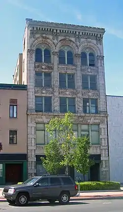 Foster Building |
June 3, 1991 (#91000664) |
508 State St. 42°48′42″N 73°56′27″W |
Schenectady | First terra-cotta building in city, and first building to show influence of City Beautiful movement, when built in 1907 |
| 27 | Franklin School | June 30, 1983 (#83001791) |
Ave. B and Mason St. 42°49′23″N 73°55′21″W |
Schenectady | ||
| 28 | Gaige Homestead | October 11, 1984 (#84003202) |
Weaver Rd. 42°44′53″N 74°09′09″W |
Duanesburg | ||
| 29 | General Electric Realty Plot | 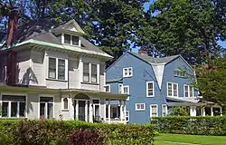 General Electric Realty Plot |
November 18, 1980 (#80002763) |
Roughly bounded by Oxford Pl., Union Ave., Nott St., Lenox and Lowell Rds. 42°49′01″N 73°55′14″W |
Schenectady | Former Union College property bought by GE in late 19th century for executives and researchers to build upscale homes on. |
| 30 | General Electric Research Laboratory | 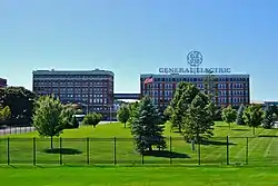 General Electric Research Laboratory |
May 15, 1975 (#75001227) |
General Electric main plant 42°48′39″N 73°57′06″W |
Schenectady | First research laboratory established by an American corporation |
| 31 | Gilbert Farmhouse | October 11, 1984 (#84003207) |
Thousand Acre Rd. 42°44′30″N 74°14′38″W |
Duanesburg | ||
| 32 | Abraham Glen House | 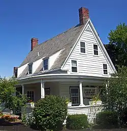 Abraham Glen House |
July 14, 2004 (#04000708) |
Mohawk Ave. 42°49′27″N 73°57′35″W |
Scotia | Rare Dutch heavy timber frame house, built in 1730s, is now Scotia's branch of the county public library |
| 33 | Glenville District No. 5 Schoolhouse | May 19, 2014 (#14000226) |
2140 Potter Rd. 42°56′22″N 74°04′53″W |
Glenville | ||
| 34 | Joseph Green Farmhouse | October 11, 1984 (#84003209) |
NY 159 42°49′43″N 74°10′43″W |
Duanesburg | ||
| 35 | Halladay Farmhouse | October 11, 1984 (#84003213) |
US 20 42°45′59″N 74°12′49″W |
Duanesburg | ||
| 36 | Hawes Homestead | October 11, 1984 (#84003217) |
Herrick Rd. 42°47′35″N 74°12′39″W |
Duanesburg | ||
| 37 | Hotel Van Curler | 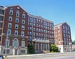 Hotel Van Curler |
September 12, 1985 (#85002277) |
78 Washington Ave. 42°48′54″N 73°56′58″W |
Schenectady | 1925 building now Elston Hall of the Schenectady County Community College |
| 38 | Horace Mann School | November 24, 2015 (#15000824) |
602 Craig St. 42°48′12″N 73°56′24″W |
Schenectady | 1908 school built to accommodate rising enrollment in a growing neighborhood | |
| 39 | Howard Homestead | October 11, 1984 (#84003220) |
McGuire School Rd. 42°46′39″N 74°13′44″W |
Duanesburg | ||
| 40 | Jenkins House |  Jenkins House |
October 11, 1984 (#84003071) |
57 Main St. 42°44′46″N 74°11′19″W |
Delanson | |
| 41 | Jenkins Octagon House |  Jenkins Octagon House |
October 11, 1984 (#84003227) |
NY 395 42°45′31″N 74°11′07″W |
Duanesburg | |
| 42 | A.D. (Boss) Jones House | 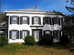 A.D. (Boss) Jones House |
October 11, 1984 (#84003231) |
McGuire School Rd. 42°46′20″N 74°12′53″W |
Duanesburg | |
| 43 | George Westinghouse Jones House | September 15, 2004 (#04000998) |
1944 Union St. 42°47′39″N 73°53′11″W |
Niskayuna | ||
| 44 | Ladd Farmhouse | October 11, 1984 (#84003238) |
Dare Rd. 42°47′18″N 74°13′33″W |
Duanesburg | ||
| 45 | Irving Langmuir House | 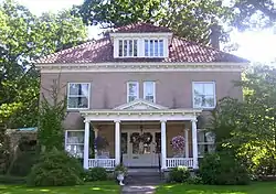 Irving Langmuir House |
January 7, 1976 (#76001275) |
1176 Stratford Rd. 42°48′58″N 73°55′09″W |
Schenectady | Home of Irving Langmuir, 1932 Nobel laureate in chemistry and first industrial chemist so honored. During his career at GE, improved functioning of light bulb, developed concentric model of atom, co-developed cloud seeding and was among first scientists to work with plasmas. |
| 46 | George Lasher House | October 11, 1984 (#84003242) |
Levey Rd. 42°50′11″N 74°09′16″W |
Duanesburg | ||
| 47 | Alexander Liddle Farmhouse | October 11, 1984 (#84003256) |
Gamsey Rd. 42°46′42″N 74°12′26″W |
Duanesburg | ||
| 48 | Robert Liddle Farmhouse | October 11, 1984 (#84003265) |
Little Dale Farm Rd. 42°46′34″N 74°07′21″W |
Duanesburg | ||
| 49 | Thomas Liddle Farm Complex | October 11, 1984 (#84003247) |
Eaton Corners Rd. 42°47′51″N 74°14′23″W |
Duanesburg | ||
| 50 | Mabee House |  Mabee House |
May 22, 1978 (#78001907) |
S of Rotterdam Junction on NY 5S 42°51′56″N 74°01′56″W |
Rotterdam Junction | |
| 51 | Macomber Stone House | October 11, 1984 (#84003266) |
Barton Hill Rd. 42°43′17″N 74°12′52″W |
Duanesburg | ||
| 52 | Mariaville Historic District | 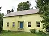 Mariaville Historic District |
October 11, 1984 (#84003267) |
NY 159 42°49′42″N 74°08′08″W |
Duanesburg | |
| 53 | Mica Insulator Company | January 4, 2012 (#11001007) |
797 & 845 Broadway 42°48′14″N 73°57′06″W |
Schenectady | ||
| 54 | New York State Barge Canal | 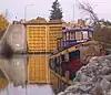 New York State Barge Canal |
October 15, 2014 (#14000860) |
Linear across county 42°49′13″N 73°56′44″W |
Schenectady, Glenville, Niskayuna, Rotterdam, Scotia | Successor to Erie Canal approved by state voters in early 20th century to compete with railroads |
| 55 | Niskayuna Railroad Station | 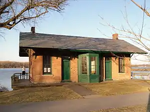 Niskayuna Railroad Station |
November 19, 2007 (#07001205) |
N. side River Rd., Lyons Park 42°46′47″N 73°49′25″W |
Niskayuna | |
| 56 | Niskayuna Reformed Church | %252C_Niskayuna_(Schenectady_County%252C_New_York).jpg.webp) Niskayuna Reformed Church |
April 18, 1979 (#79001628) |
3041 Troy-Schenectady Rd. 42°46′34″N 73°49′56″W |
Niskayuna | |
| 57 | North Mansion and Tenant House | .jpg.webp) North Mansion and Tenant House |
April 24, 1987 (#87000909) |
North Mansion Rd. 42°45′13″N 74°06′52″W |
Duanesburg | |
| 58 | Nott Memorial Hall | 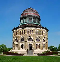 Nott Memorial Hall |
May 5, 1972 (#72000912) |
Union College campus 42°49′02″N 73°55′49″W |
Schenectady | 16-sided domed building at center of campus considered fine example of Victorian Gothic. Has had many uses over years; completely restored in 1990s. |
| 59 | Nott Street School | December 29, 2011 (#11000970) |
487 Nott St. 42°49′14″N 73°55′52″W |
Schenectady | ||
| 60 | F. F. Proctor Theatre and Arcade | 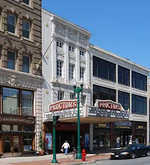 F. F. Proctor Theatre and Arcade |
October 4, 1979 (#79003237) |
432 State St. 42°48′44″N 73°56′31″W |
Schenectady | 1926 theater recently renovated. One of the most lavish in nation when built; hosted first public demonstration of television in 1930. |
| 61 | Quaker Street Historic District | 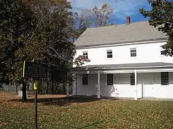 Quaker Street Historic District |
October 11, 1984 (#84003270) |
Schoharie Tpk., Gallupville and Darby Hill Rds. 42°44′01″N 74°11′16″W |
Duanesburg | |
| 62 | Reformed Presbyterian Church Parsonage | October 11, 1984 (#84003271) |
Duanesburg Churches Rd. 42°46′16″N 74°09′26″W |
Duanesburg | ||
| 63 | Rosendale Common School | July 19, 2010 (#10000482) |
2572 Rosendale Rd. 42°47′46″N 73°51′31″W |
Niskayuna vicinity | ||
| 64 | Schenectady Armory | 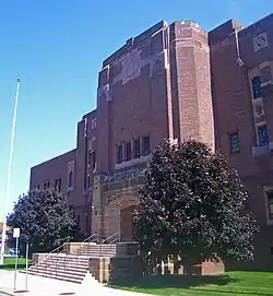 Schenectady Armory |
March 2, 1995 (#95000087) |
125 Washington Ave. 42°48′48″N 73°56′58″W |
Schenectady | Intact 1936 Art Deco armory, unusually located in center (at the time) of city rather than outskirts |
| 65 | Schenectady City Hall and Post Office | 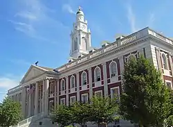 Schenectady City Hall and Post Office |
October 11, 1978 (#78001908) |
Jay St. 42°48′51″N 73°56′22″W |
Schenectady | 1931 McKim, Mead and White building with window arches matching nearby post office |
| 66 | Schenectady Police Department | August 5, 2022 (#100007961) |
301 Clinton St. 42°48′40″N 73°56′32″W |
Schenectady | ||
| 67 | Schenectady Public Market and Scale House | January 27, 2022 (#100007377) |
Bounded by Clinton St., Van Guysling Ave., Broadway, and Hamilton St. 42°48′36″N 73°56′42″W |
Schenectady | ||
| 68 | Schenectady Savings Bank | March 16, 2022 (#100007378) |
500 State St. 42°48′43″N 73°56′26″W |
Schenectady | ||
| 69 | Seeley Farmhouse | May 23, 1978 (#78001909) |
2 Freeman's Bridge Rd. 42°49′54″N 73°55′50″W |
Glenville | ||
| 70 | Sheldon Farmhouse | October 11, 1984 (#84003273) |
NY 7 42°43′27″N 74°15′20″W |
Duanesburg | ||
| 71 | Shute Octagon House | 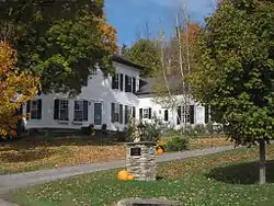 Shute Octagon House |
October 11, 1984 (#84003276) |
McGuire School Rd. 42°46′28″N 74°13′10″W |
Duanesburg | |
| 72 | St. Columba's School | December 1, 2015 (#15000853) |
400 Craig St. 42°48′19″N 73°56′18″W |
Schenectady | 1923 school was central to city's Irish Catholic population | |
| 73 | St. Mary's Catholic Church Complex | June 12, 2017 (#100001071) |
820-828 Eastern Ave. & 104 Irving St. 42°48′41″N 73°55′41″W |
Schenectady vicinity | Stone church and several other buildings erected in early 20th century to serve the city's growing Polish immigrant population remained in use until 2009 | |
| 74 | Stockade Historic District | 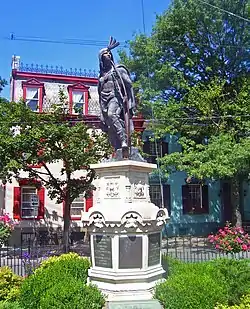 Stockade Historic District |
April 3, 1973 (#73001267) |
Roughly bounded by Mohawk River, RR tracks, and Union St. 42°49′07″N 73°56′47″W |
Schenectady | Oldest section of city, with many houses dating to 18th century |
| 75 | Swart House and Tavern | January 4, 2007 (#06001211) |
130 Johnson Rd. 42°53′10″N 74°03′02″W |
Glenville | ||
| 76 | Union Street Historic District | 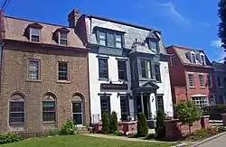 Union Street Historic District |
November 17, 1982 (#82001268) |
Union St. from Hudson River to Phoenix Ave. 42°48′46″N 73°55′41″W |
Schenectady | Intact 19th century development along main axis of city's expansion during that period. |
| 77 | US Post Office-Schenectady | US Post Office-Schenectady |
May 11, 1989 (#88002429) |
29 Jay St.[5] 42°48′53″N 73°56′21″W |
Schenectady | 1912 neoclassical building added onto during Depression |
| 78 | US Post Office-Scotia Station | 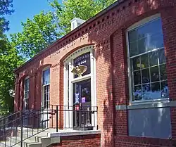 US Post Office-Scotia Station |
May 11, 1989 (#88002430) |
224 Mohawk Ave. 42°49′38″N 73°57′59″W |
Scotia | Detailed Colonial Revival post office built 1939–40 |
| 79 | Vale Cemetery and Vale Park | 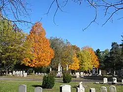 Vale Cemetery and Vale Park |
September 24, 2004 (#04001053) |
907 State St., Nott Terrace 42°48′26″N 73°55′45″W |
Schenectady | (Article on the combo of Vale Cemetery AND the park is needed) |
| 80 | Wedgeway Building | .jpg.webp) Wedgeway Building |
June 17, 2022 (#100007805) |
271-277 State St. 42°48′52″N 73°56′39″W |
Schenectady | Originally the old Proctor's Theatre, which opened April 8, 1912 and closed in December 1926 when the new Proctor's Theatre opened at 432 State Street. Re-opened in April 1927 as Wedgeway Theatre and renamed Erie Theatre in September 1930.[6] |
| 81 | Joseph Wing Farm Complex | October 11, 1984 (#84003279) |
NY 30 42°43′47″N 74°17′10″W |
Duanesburg | ||
| 82 | William R. Wing Farm Complex | October 11, 1984 (#84003281) |
US 20 42°45′52″N 74°14′15″W |
Duanesburg | ||
| 83 | Yates House | January 31, 2019 (#100003396) |
133 Maple Ave. 42°51′31″N 73°54′29″W |
Schenectady | ||
| 84 | Young Men's Christian Association of Schenectady | December 1, 2015 (#15000854) |
9–13 State St. 42°48′55″N 73°57′03″W |
Schenectady | 1928 building dates to first national spurt of YMCA growth |
See also
Wikimedia Commons has media related to National Register of Historic Places in Schenectady County, New York.
References
- The latitude and longitude information provided in this table was derived originally from the National Register Information System, which has been found to be fairly accurate for about 99% of listings. Some locations in this table may have been corrected to current GPS standards.
- National Park Service, United States Department of the Interior, "National Register of Historic Places: Weekly List Actions", retrieved October 20, 2023.
- Numbers represent an alphabetical ordering by significant words. Various colorings, defined here, differentiate National Historic Landmarks and historic districts from other NRHP buildings, structures, sites or objects.
- The eight-digit number below each date is the number assigned to each location in the National Register Information System database, which can be viewed by clicking the number.
- Address based on USPS website. Accessed April 2, 2016.
- "Erie Theatre". Cinema Treasures. Retrieved December 14, 2022.

This article is issued from Wikipedia. The text is licensed under Creative Commons - Attribution - Sharealike. Additional terms may apply for the media files.