National Register of Historic Places listings in Woodbury County, Iowa
This is a list of the National Register of Historic Places listings in Woodbury County, Iowa.

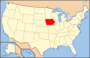
Location of Woodbury County in Iowa
This is intended to be a complete list of the properties and districts on the National Register of Historic Places in Woodbury County, Iowa, United States. Latitude and longitude coordinates are provided for many National Register properties and districts; these locations may be seen together in a map.[1]
There are 60 properties and districts listed on the National Register in the county, including three National Historic Landmarks. An additional four properties were once listed, but have since been removed.
This National Park Service list is complete through NPS recent listings posted October 20, 2023.[2]
| [3] | Name on the Register[4] | Image | Date listed[5] | Location | City or town | Description |
|---|---|---|---|---|---|---|
| 1 | Albertson and Company-Rocklin Manufacturing Company | 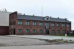 Albertson and Company-Rocklin Manufacturing Company |
May 9, 2019 (#100003944) |
110 S. Jennings St. 42°29′25″N 96°23′57″W |
Sioux City | |
| 2 | Alhambra Apartments | _from_SW_1.JPG.webp) Alhambra Apartments |
October 12, 2001 (#01001089) |
801 8th St. 42°29′56″N 96°24′01″W |
Sioux City | |
| 3 | Atchison A. Ashby House | _from_E_1.JPG.webp) Atchison A. Ashby House |
September 25, 1998 (#98001207) |
1807 Summit St. 42°30′34″N 96°24′36″W |
Sioux City | |
| 4 | Badgerow Building |  Badgerow Building |
March 24, 1982 (#82002646) |
622 4th St. 42°29′38″N 96°24′08″W |
Sioux City | |
| 5 | George A. and Mary Tinkel Bailey House | 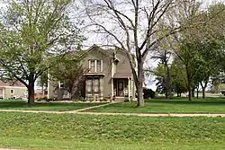 George A. and Mary Tinkel Bailey House |
August 5, 1998 (#98000929) |
423 10th St. 42°28′53″N 95°47′03″W |
Correctionville | |
| 6 | W.L. and Winnie (Woodfield) Belfrage Farmstead Historic District | November 16, 2017 (#100001819) |
2410 Port Neal Rd. 42°21′32″N 96°21′01″W |
Sergeant Bluff | ||
| 7 | Benson Archeological Site (13WD50) | April 24, 1984 (#84001611) |
Address Restricted |
Smithland | ||
| 8 | Boston Block | _from_SW_1.JPG.webp) Boston Block |
January 3, 1985 (#85000010) |
1005-1013 E. 4th St. 42°29′40″N 96°23′50″W |
Sioux City | |
| 9 | Theophile Bruguier Cabin | 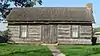 Theophile Bruguier Cabin |
August 14, 2000 (#00000918) |
Riverside Park 42°29′48″N 96°28′31″W |
Sioux City | |
| 10 | Elzy G. Burkam House | _from_SE_1.JPG.webp) Elzy G. Burkam House |
July 15, 1998 (#98000864) |
1525 Douglas St. 42°30′25″N 96°24′25″W |
Sioux City | |
| 11 | Charles City College Hall | 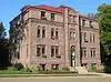 Charles City College Hall |
January 21, 1983 (#83000412) |
1501 Morningside Ave. 42°28′31″N 96°21′36″W |
Sioux City | |
| 12 | Chicago, Milwaukee, St. Paul & Pacific Combination Depot-Hornick | 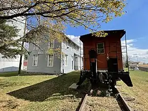 Chicago, Milwaukee, St. Paul & Pacific Combination Depot-Hornick |
September 6, 1990 (#90001309) |
Main St. south of Railway St. 42°13′51″N 96°05′51″W |
Hornick | |
| 13 | Davidson Building | _from_SW_1.JPG.webp) Davidson Building |
June 25, 1999 (#99000736) |
505 6th St. 42°29′48″N 96°24′17″W |
Sioux City | |
| 14 | Dick's Diner | October 6, 2023 (#100009407) |
723 West 7th St. 42°30′10″N 96°25′01″W |
Sioux City | ||
| 15 | Evans Block | _from_NE_2.JPG.webp) Evans Block |
January 3, 1985 (#85000011) |
1126-28 4th St. 42°29′39″N 96°23′42″W |
Sioux City | |
| 16 | Everett School | November 5, 2018 (#100003066) |
1314 W 3rd St. 42°29′57″N 96°25′31″W |
Sioux City | ||
| 17 | H.H. Everist House | H.H. Everist House |
September 29, 1983 (#83000413) |
37 McDonald Dr. 42°31′08″N 96°24′40″W |
Sioux City | |
| 18 | Fourth Street Historic District | 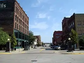 Fourth Street Historic District |
August 15, 1995 (#95000966) |
1002-1128 4th St. 42°29′39″N 96°23′46″W |
Sioux City | |
| 19 | Grandview Park Music Pavilion | 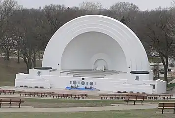 Grandview Park Music Pavilion |
February 28, 2011 (#11000053) |
Sits to the east of McDonald St. -- Entrance in 2600 block of McDonald St. 42°31′00″N 96°24′35″W |
Sioux City | |
| 20 | Great Northern Railway Steam Locomotive No. 1355 and Tender 1451 | 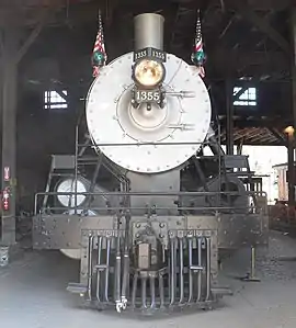 Great Northern Railway Steam Locomotive No. 1355 and Tender 1451 |
December 15, 2004 (#04001352) |
3400 Sioux River Rd. 42°31′45″N 96°28′36″W |
Sioux City | |
| 21 | Holy Trinity Greek Orthodox Church | 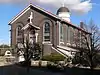 Holy Trinity Greek Orthodox Church |
May 1, 1998 (#98000381) |
900 6th St. 42°29′46″N 96°23′55″W |
Sioux City | |
| 22 | Hubbard Park | October 10, 2023 (#100009432) |
2800 Jones St. 42°31′09″N 96°24′03″W |
Sioux City | ||
| 23 | Dr. Van Buren Knott House | _from_E_1.JPG.webp) Dr. Van Buren Knott House |
September 8, 1999 (#99001032) |
2323 Nebraska St. 42°30′54″N 96°24′15″W |
Sioux City | |
| 24 | Leeds Junior High School | Leeds Junior High School |
October 24, 2002 (#02001228) |
3919 Jefferson St. 42°32′15″N 96°22′04″W |
Sioux City | Demolished ca. 2008[6] |
| 25 | Lewis System Armored Car and Detective Service Building | 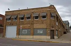 Lewis System Armored Car and Detective Service Building |
October 4, 2016 (#16000689) |
700 Nebraska St. 42°29′51″N 96°24′12″W |
Sioux City | |
| 26 | Martin Hotel | _from_SW_2.jpg.webp) Martin Hotel |
January 27, 1983 (#83000414) |
410 Pierce St. 42°29′40″N 96°24′15″W |
Sioux City | |
| 27 | T.S. Martin and Company | 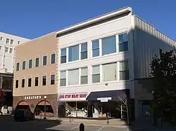 T.S. Martin and Company |
July 15, 1998 (#98000865) |
Junction of 4th St. and Nebraska St. 42°29′40″N 96°24′14″W |
Sioux City | |
| 28 | Mary Elizabeth Day Nursery | _from_W_1.JPG.webp) Mary Elizabeth Day Nursery |
October 30, 1997 (#97001293) |
814 Court St. 42°29′57″N 96°23′46″W |
Sioux City | |
| 29 | Milwaukee Railroad Shops Historic District | October 22, 2018 (#100002243) |
3400 Sioux River Rd. 42°31′39″N 96°28′34″W |
Sioux City | ||
| 30 | Morningside College Historic District |  Morningside College Historic District |
May 14, 1997 (#97000387) |
Roughly bounded by Vine, Morningside, Garretson, Peters, and S. Paxton Aves. and Sioux Trail 42°28′28″N 96°21′42″W |
Sioux City | |
| 31 | Motor Mart Building | _from_SW_2.JPG.webp) Motor Mart Building |
April 22, 1993 (#93000330) |
520 Nebraska St. 42°29′46″N 96°24′12″W |
Sioux City | |
| 32 | Mount Sinai Temple | Mount Sinai Temple |
October 21, 1999 (#99001268) |
1320 Nebraska St. 42°30′18″N 96°24′10″W |
Sioux City | |
| 33 | Municipal Auditorium | Municipal Auditorium |
July 27, 2006 (#06000316) |
500 Gordon Dr. 42°29′34″N 96°24′24″W |
Sioux City | |
| 34 | Mylius-Eaton House | 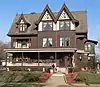 Mylius-Eaton House |
January 13, 2004 (#03001390) |
2900 Jackson St. 42°31′15″N 96°24′07″W |
Sioux City | |
| 35 | New Orpheum Theatre | 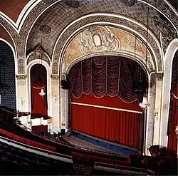 New Orpheum Theatre |
August 25, 2000 (#00000919) |
520-28 Pierce St. 42°29′44″N 96°24′17″W |
Sioux City | Restored theatre complex that was built in 1927 |
| 36 | James P. Newton House and Maid Cottage | _from_NW_1.JPG.webp) James P. Newton House and Maid Cottage |
March 3, 2000 (#00000154) |
2312 Nebraska St. 42°30′53″N 96°24′12″W |
Sioux City | |
| 37 | Julius and Anine Oversen House | _from_E_1.JPG.webp) Julius and Anine Oversen House |
March 28, 2007 (#07000207) |
2037 S. Lemon St. 42°28′08″N 96°20′33″W |
Sioux City | |
| 38 | John Peirce House | 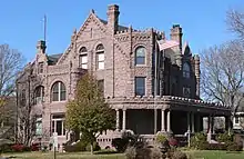 John Peirce House |
December 12, 1978 (#78001273) |
2901 Jackson St. 42°31′15″N 96°24′08″W |
Sioux City | |
| 39 | Rose Hill Historic District | 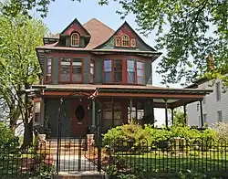 Rose Hill Historic District |
September 12, 2002 (#02001022) |
1400-1700 blocks of Douglas St., Grandview Boulevard, and Summit St. 42°30′08″N 96°24′48″W |
Sioux City | |
| 40 | St. Boniface Historic District | _from_NE_1.jpg.webp) St. Boniface Historic District |
November 5, 1998 (#98001322) |
703 W. 5th St., 515 Cook St., and 700 W. 6th St. 42°30′04″N 96°25′03″W |
Sioux City | |
| 41 | St. Thomas Episcopal Church | 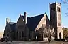 St. Thomas Episcopal Church |
September 27, 1984 (#84001612) |
1200 Douglas St. 42°30′11″N 96°24′23″W |
Sioux City | |
| 42 | Arthur and Stella Sanford House | _from_E_1.JPG.webp) Arthur and Stella Sanford House |
May 9, 2003 (#03000359) |
1925 Summit 42°30′39″N 96°24′36″W |
Sioux City | |
| 43 | Ben and Harriet Schulein House | _from_W_1.JPG.webp) Ben and Harriet Schulein House |
October 30, 1997 (#97001289) |
2604 Jackson St. 42°31′03″N 96°24′07″W |
Sioux City | Built in 1913, this represents William L. Steele's first tentative venture into the Prairie School style of architecture for which he is now best known. |
| 44 | SERGEANT FLOYD | 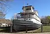 SERGEANT FLOYD |
May 5, 1989 (#89001079) |
Missouri River Mile Marker 730 42°30′04″N 96°28′21″W |
Sioux City | |
| 45 | Sergeant Floyd Monument | 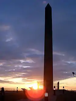 Sergeant Floyd Monument |
October 15, 1966 (#66000340) |
Glenn Ave. and Lewis Rd. 42°27′45″N 96°22′39″W |
Sioux City | |
| 46 | Simmons Hardware Company Warehouse | _from_SE_2.JPG.webp) Simmons Hardware Company Warehouse |
April 25, 2008 (#08000332) |
323 Water St. 42°29′38″N 96°24′36″W |
Sioux City | |
| 47 | Sioux City Baptist Church | 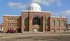 Sioux City Baptist Church |
October 22, 1979 (#79000953) |
1301 Nebraska Ave. 42°30′15″N 96°24′14″W |
Sioux City | Built in 1918 by Prairie School architect William L. Steele as the First Congregational Church, it gained NRHP status as Sioux City Baptist, and is now Iglesia Pentecostes Evangelica Principe de Paz. |
| 48 | Sioux City Central High School and Central Annex | 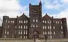 Sioux City Central High School and Central Annex |
July 23, 1974 (#74000817) |
1212 Nebraska & 1121 Jackson Sts. 42°30′13″N 96°24′10″W |
Sioux City | Boundary increase and rename, September 19, 2016 |
| 49 | Sioux City Fire Station Number 3 | 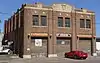 Sioux City Fire Station Number 3 |
May 21, 2008 (#08000444) |
1211 5th St. 42°29′44″N 96°23′40″W |
Sioux City | |
| 50 | Sioux City Free Public Library | 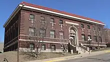 Sioux City Free Public Library |
June 2, 1997 (#97000461) |
705 6th St. 42°29′48″N 96°24′06″W |
Sioux City | |
| 51 | Sioux City Linseed Oil Works | 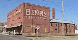 Sioux City Linseed Oil Works |
January 10, 2008 (#07001359) |
210 Court St. 42°29′33″N 96°23′46″W |
Sioux City | |
| 52 | Sioux City Masonic Temple | Sioux City Masonic Temple |
January 14, 2004 (#03001389) |
820 Nebraska St. 42°29′58″N 96°24′05″W |
Sioux City | |
| 53 | Sioux City Public Library (Smith Villa Branch) | 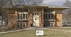 Sioux City Public Library (Smith Villa Branch) |
May 23, 1983 (#83000415) |
1509 George Ave. 42°30′23″N 96°25′39″W |
Sioux City | |
| 54 | Sioux City Public Library-North Side Branch | 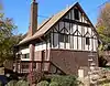 Sioux City Public Library-North Side Branch |
December 7, 2000 (#00001479) |
810 29th St. 42°31′14″N 96°24′01″W |
Sioux City | |
| 55 | Swedish Evangelical Lutheran Augustana Church | _from_NW_1.JPG.webp) Swedish Evangelical Lutheran Augustana Church |
May 30, 2006 (#06000444) |
600 Court St. 42°29′48″N 96°23′46″W |
Sioux City | |
| 56 | United States Post Office and Courthouse | 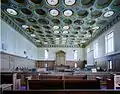 United States Post Office and Courthouse |
July 17, 2013 (#13000485) |
316–320 6th Street 42°29′46″N 96°24′26″W |
Sioux City | |
| 57 | Warnock Building | February 13, 2023 (#100008628) |
701-705 Douglas St. 42°29′52″N 96°24′25″W |
Sioux City | ||
| 58 | Warrior Hotel | _from_SE_1.JPG.webp) Warrior Hotel |
June 27, 1985 (#85001384) |
6th and Nebraska Sts. 42°29′48″N 96°24′14″W |
Sioux City | |
| 59 | Williges Building | _from_E_1.JPG.webp) Williges Building |
August 31, 2007 (#07000850) |
613-615 Pierce St. 42°29′49″N 96°24′19″W |
Sioux City | |
| 60 | Woodbury County Courthouse |  Woodbury County Courthouse |
December 18, 1973 (#73000744) |
7th and Douglas Sts. 42°29′50″N 96°24′20″W |
Sioux City |
Former listings
| [3] | Name on the Register | Image | Date listed | Date removed | Location | City or town | Description |
|---|---|---|---|---|---|---|---|
| 1 | Florence Crittenton Home and Maternity Hospital | Florence Crittenton Home and Maternity Hospital |
March 31, 2000 (#00000306) | August 16, 2018 | 1105-1111 28th St. 42°31′10″N 96°23′45″W |
Sioux City | Home designed by William L. Steele with W.W. Beach in 1906; hospital by Beuttler & Arnold in 1913. |
| 2 | Margaretta Franz House | June 21, 1982 (#82002647) | May 22, 1998 | 215 Kansas St. |
Sioux City | Demolished[7] | |
| 3 | Knapp-Spencer Warehouse | June 21, 1982 (#82002648) | May 22, 1998 | 3rd and Nebraska Sts. |
Sioux City | Demolished in July, 1993[8] | |
| 4 | Lexington Block | April 11, 1986 (#86000706) | May 22, 1998 | 815 4th St. |
Sioux City | Demolished | |
| 5 | Midland Packing Company | 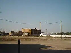 Midland Packing Company |
January 25, 1979 (#79000952) | March 7, 2019 | 2001 Leech Ave. 42°29′19″N 96°22′59″W |
Sioux City | Demolished in 2009[9][10] |
See also
Wikimedia Commons has media related to National Register of Historic Places in Woodbury County, Iowa.
- List of National Historic Landmarks in Iowa
- National Register of Historic Places listings in Iowa
- Listings in neighboring counties: Cherokee, Dakota (NE), Ida, Monona, Plymouth, Thurston (NE), Union (SD)
References
- The latitude and longitude information provided in this table was derived originally from the National Register Information System, which has been found to be fairly accurate for about 99% of listings. Some locations in this table may have been corrected to current GPS standards.
- National Park Service, United States Department of the Interior, "National Register of Historic Places: Weekly List Actions", retrieved October 20, 2023.
- Numbers represent an alphabetical ordering by significant words. Various colorings, defined here, differentiate National Historic Landmarks and historic districts from other NRHP buildings, structures, sites or objects.
- "National Register Information System". National Register of Historic Places. National Park Service. April 24, 2008.
- The eight-digit number below each date is the number assigned to each location in the National Register Information System database, which can be viewed by clicking the number.
- "Open house at new Leeds Elementary School set for Sunday". Sioux City Journal. 2008-09-15. Retrieved 2015-09-28.
- Sioux City Historic Preservation Committee
- "Demolition cran buckles, narrowly missing vehicle". Sioux City Journal. July 28, 1993. p. A14. Retrieved June 26, 2022 – via Newspapers.com.
- Zerschling, Lynn. "KD Station site cleared, future uncertain". Sioux City Journal. 2010-06-26. Retrieved 2015-09-29.
- "KD Station Demolition". Soux City Journal. October 14, 2009. p. A3. Retrieved June 26, 2022 – via Newspapers.com.
| Topics | |
|---|---|
| Lists by state |
|
| Lists by insular areas | |
| Lists by associated state | |
| Other areas | |
| Related | |
Municipalities and communities of Woodbury County, Iowa, United States | ||
|---|---|---|
| Cities | Map of Iowa highlighting Woodbury County | |
| CDP | ||
| Other communities | ||
| Indian reservations | ||
| Ghost towns | ||
| Civil townships | ||
| Footnotes | ‡This populated place also has portions in an adjacent county or counties | |
This article is issued from Wikipedia. The text is licensed under Creative Commons - Attribution - Sharealike. Additional terms may apply for the media files.