Œuf-en-Ternois
Œuf-en-Ternois is a commune in the Pas-de-Calais department in the Hauts-de-France region of France.[3]
Œuf-en-Ternois | |
|---|---|
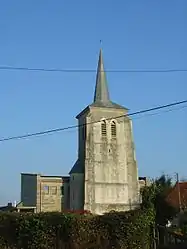 The church of Œuf-en-Ternois | |
 Coat of arms | |
Location of Œuf-en-Ternois | |
 Œuf-en-Ternois  Œuf-en-Ternois | |
| Coordinates: 50°21′32″N 2°12′46″E | |
| Country | France |
| Region | Hauts-de-France |
| Department | Pas-de-Calais |
| Arrondissement | Arras |
| Canton | Saint-Pol-sur-Ternoise |
| Intercommunality | Ternois |
| Government | |
| • Mayor (2020–2026) | Eric Roussel[1] |
| Area 1 | 8.75 km2 (3.38 sq mi) |
| Population | 256 |
| • Density | 29/km2 (76/sq mi) |
| Time zone | UTC+01:00 (CET) |
| • Summer (DST) | UTC+02:00 (CEST) |
| INSEE/Postal code | 62633 /62130 |
| Elevation | 64–135 m (210–443 ft) (avg. 118 m or 387 ft) |
| 1 French Land Register data, which excludes lakes, ponds, glaciers > 1 km2 (0.386 sq mi or 247 acres) and river estuaries. | |
Geography
Œuf-en-Ternois is situated 29 miles (47 km) west of Arras, at the junction of the D99 and D105 roads.
Population
| Year | Pop. | ±% p.a. |
|---|---|---|
| 1968 | 250 | — |
| 1975 | 247 | −0.17% |
| 1982 | 227 | −1.20% |
| 1990 | 254 | +1.41% |
| 1999 | 226 | −1.29% |
| 2007 | 253 | +1.42% |
| 2012 | 255 | +0.16% |
| 2017 | 249 | −0.48% |
| Source: INSEE[4] | ||
Places of interest
- The church of St.Martin, dating from the twentieth century.
References
- "Répertoire national des élus: les maires". data.gouv.fr, Plateforme ouverte des données publiques françaises (in French). 9 August 2021.
- "Populations légales 2020". The National Institute of Statistics and Economic Studies. 29 December 2022.
- INSEE commune file
- Population en historique depuis 1968, INSEE
This article is issued from Wikipedia. The text is licensed under Creative Commons - Attribution - Sharealike. Additional terms may apply for the media files.