Oxkutzcab Municipality
Oxkutzcab Municipality (sometimes spelled as Oxcutzcab) is a municipality, with a municipal seat of the same name in the Mexican state of Yucatán, southeast of Maní, Yucatán, located at 20°18′10″N 89°25′0″W. The name in the Yucatec Maya language means "Place of ramon, tobacco, and honey".
Oxkutzcab | |
|---|---|
Municipality | |
 "20 de noviembre" Market in Oxkutzcab | |
 Seal | |
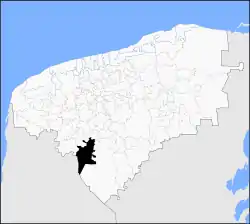 Location of Oxkutzcab in Yucatán | |
 Oxkutzcab Location of Oxkutzcab in Mexico | |
| Coordinates: 20°18′N 89°25′W | |
| Country | Mexico |
| State | Yucatán |
| Government | |
| • Municipal President | José Gualberto Ayora Cámara[1] |
| Area | |
| • Total | 512.23 km2 (197.77 sq mi) |
| [1] | |
| Population | |
| • Total | 27,084 |
| • Density | 53/km2 (140/sq mi) |
| Time zone | UTC-6 (Central Standard Time) |
| • Summer (DST) | UTC-5 (Central Daylight Time) |
| INEGI Code | 056 |
| Major Airport | Merida (Manuel Crescencio Rejón) International Airport |
| IATA Code | MID |
| ICAO Code | MMMD |
According to the 2005 census, Oxkutzcab had a population of 21,341[3] people in the city and 27,084[3] in the entire municipality, predominantly of Maya descent. Henequen, sugar, tobacco, maize, and fruit are grown commercially in the surrounding area. The municipality has an area of 512.23 km2 (197.77 sq mi) and includes a number of smaller towns, the largest of which are Yaxhachén, Xohuayán, Emiliano Zapata, and Xul. Loltun Cave is 5 km (3.1 mi) south of the city.
Climate
| Climate data for Oxcutzcab | |||||||||||||
|---|---|---|---|---|---|---|---|---|---|---|---|---|---|
| Month | Jan | Feb | Mar | Apr | May | Jun | Jul | Aug | Sep | Oct | Nov | Dec | Year |
| Average high °C (°F) | 29.6 (85.3) |
31.3 (88.3) |
33.5 (92.3) |
35.5 (95.9) |
37.0 (98.6) |
35.5 (95.9) |
34.9 (94.8) |
34.8 (94.6) |
34.2 (93.6) |
32.3 (90.1) |
30.9 (87.6) |
29.6 (85.3) |
33.3 (91.9) |
| Average low °C (°F) | 14.8 (58.6) |
15.4 (59.7) |
16.8 (62.2) |
19 (66) |
20.9 (69.6) |
21.6 (70.9) |
21.0 (69.8) |
21.2 (70.2) |
21.3 (70.3) |
20 (68) |
18 (64) |
16.0 (60.8) |
18.8 (65.8) |
| Average precipitation mm (inches) | 28 (1.1) |
20 (0.8) |
38 (1.5) |
46 (1.8) |
86 (3.4) |
150 (6.1) |
150 (6.1) |
190 (7.5) |
200 (7.7) |
110 (4.2) |
51 (2) |
51 (2) |
1,130 (44.3) |
| Source: Weatherbase [4] | |||||||||||||
References
- "Nuestros municipios - Oxcutzcab". Retrieved October 16, 2013.
- "Encyclopedia of the Municipalities of Mexico: Yucatan". Archived from the original on 2008-11-20. Retrieved 2009-11-01.
- Census Results by Locality, 2005 Archived 2011-07-22 at the Wayback Machine INEGI.
- "Weatherbase: Historical Weather for Oxcutzcab, Yucatán". Weatherbase. 2011. Retrieved on November 24, 2011.
External links
- Ayuntamiento de Oxkutzcab Possible future official website
- Oxkutzcab on Yucatan Today
- Oxkutzcab.com (in Spanish)
- Images and articles of Oxkutzcab including panoramic views (in Spanish)
Mérida (capital) | |||||||||||||||
| Topics | 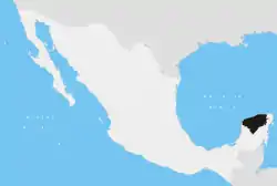 | ||||||||||||||
| Metros | |||||||||||||||
| Larger cities | |||||||||||||||
| Smaller cities |
| ||||||||||||||
| Municipalities |
| ||||||||||||||