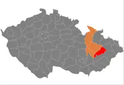
Přerov District
Přerov District (Czech: okres Přerov) is a district in the Olomouc Region of the Czech Republic. Its capital is the city of Přerov.
Přerov District
Okres Přerov | |
|---|---|
 Location in the Olomouc Region within the Czech Republic | |
| Coordinates: 49°30′N 17°35′E | |
| Country | |
| Region | Olomouc |
| Capital | Přerov |
| Area | |
| • Total | 854.35 km2 (329.87 sq mi) |
| Population (2023)[2] | |
| • Total | 128,180 |
| • Density | 150/km2 (390/sq mi) |
| Time zone | UTC+1 (CET) |
| • Summer (DST) | UTC+2 (CEST) |
| Municipalities | 105 |
| * Cities and towns | 6 |
| * Market towns | 3 |
Administrative division
Přerov District is divided into three administrative districts of municipalities with extended competence: Přerov, Hranice and Lipník nad Bečvou.
List of municipalities
Cities and towns are marked in bold and market towns in italics:
Bělotín - Beňov - Bezuchov - Bohuslávky - Bochoř - Brodek u Přerova - Buk - Býškovice - Čechy - Čelechovice - Černotín - Císařov - Citov - Dobrčice - Dolní Nětčice - Dolní Těšice - Dolní Újezd - Domaželice - Dřevohostice - Grymov - Hlinsko - Horní Moštěnice - Horní Nětčice - Horní Těšice - Horní Újezd - Hrabůvka - Hradčany - Hranice - Hustopeče nad Bečvou - Jezernice - Jindřichov - Kladníky - Klokočí - Kojetín - Kokory - Křenovice - Křtomil - Lazníčky - Lazníky - Lhota - Lhotka - Lipník nad Bečvou - Lipová - Líšná - Lobodice - Malhotice - Měrovice nad Hanou - Milenov - Milotice nad Bečvou - Nahošovice - Nelešovice - Oldřichov - Olšovec - Opatovice - Oplocany - Oprostovice - Osek nad Bečvou - Paršovice - Partutovice - Pavlovice u Přerova - Podolí - Polkovice - Polom - Potštát - Přerov - Přestavlky - Prosenice - Provodovice - Radíkov - Radkova Lhota - Radkovy - Radotín - Radslavice - Radvanice - Rakov - Rokytnice - Rouské - Říkovice - Skalička - Soběchleby - Sobíšky - Stará Ves - Stříbrnice - Střítež nad Ludinou - Sušice - Šišma - Špičky - Teplice nad Bečvou - Tovačov - Troubky - Tučín - Turovice - Týn nad Bečvou - Uhřičice - Ústí - Veselíčko - Věžky - Vlkoš - Všechovice - Výkleky - Zábeštní Lhota - Žákovice - Zámrsky - Želatovice
Geography
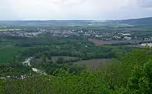
The landscape is mainly flat in the west and undulating in the east. The district is characterized by a deforested fertile landscape. The territory extends into five geomorphological mesoregions: Upper Morava Valley (west), Nízký Jeseník (north), Moravian Gate (a strip from east to centre), Moravian-Silesian Foothills (south), and Litenčice Hills (a small part in the southwest). The highest point of the district is the hill Strážná in Luboměř pod Strážnou with an elevation of 642 m (2,106 ft), the lowest point is the river bed of the Morava in Kojetín at 191 m (627 ft).
From the total district area of 854.4 km2 (329.9 sq mi), agricultural land occupies 584.4 km2 (225.6 sq mi), forests occupy 140.1 km2 (54.1 sq mi), and water area occupies 18.4 km2 (7.1 sq mi). Forests cover 16.4% of the district's area.[1]
The largest river is the Morava, which crosses the territory in its western part. The longest river within the district is the Bečva, which flows across the district from east to west and then joins the Morava. Around the Morava there are several ponds and artificial lakes created by flooding gravel quarries; otherwise there are not many bodies of water.
There are no large-scale protected areas.
Demographics
|
|
| ||||||||||||||||||||||||||||||||||||||||||||||||||||||
| Source: Censuses[3][4] | ||||||||||||||||||||||||||||||||||||||||||||||||||||||||
Most populated municipalities
| Name | Population[2] | Area (km2) |
|---|---|---|
| Přerov | 41,634 | 58 |
| Hranice | 17,978 | 50 |
| Lipník nad Bečvou | 7,981 | 31 |
| Kojetín | 5,844 | 31 |
| Tovačov | 2,475 | 23 |
| Troubky | 2,029 | 21 |
| Brodek u Přerova | 1,888 | 9 |
| Bělotín | 1,829 | 33 |
| Hustopeče nad Bečvou | 1,744 | 24 |
| Horní Moštěnice | 1,685 | 10 |
Economy
The largest employers with headquarters in Přerov District and at least 500 employees are:[5]
| Economic entity | Location | Number of employees | Main activity |
|---|---|---|---|
| Meopta - optika | Přerov | 1,500–1,999 | Manufacture of optical instruments |
| SSI Schäfer | Hranice | 1,000–1,499 | Manufacture of metal structures |
| Henniges Hranice | Hranice | 500–999 | Manufacture of rubber products for automotive industry |
| Hranice Hospital | Hranice | 500–999 | Health care |
| KROK CZ | Hranice | 500–999 | Manufacture of work clothes |
| DPOV | Přerov | 500–999 | Repair and maintenance of rolling stock |
| Precheza | Přerov | 500–999 | Chemical industry |
Transport
The D1 motorway (part of the European route E462) from Brno to Ostrava runs across the district. An unfinished section of the motorway is replaced by the I/55 road. The D35 motorway heading to Olomouc separates from the D1 near Lipník nad Bečvou. The D48 motorway heading to Frýdek-Místek (further continuation of the European route E462) separates from the D1 near Hranice.
Sights
.jpg.webp)
There are no national cultural monuments in the district.[6]
The best-preserved settlements, protected as monument reservations and monument zones, are:[7]
The most visited tourist destination is the Helfštýn Castle.[8]
Notable people
References
- "Land use (as at 31 December)". Public database. Czech Statistical Office. Retrieved 2023-05-18.
- "Population of Municipalities – 1 January 2023". Czech Statistical Office. 2023-05-23.
- "Historický lexikon obcí České republiky 1869–2011 – Okres Přerov" (in Czech). Czech Statistical Office. 2015-12-21. pp. 1–2.
- "Population Census 2021: Population by sex". Public Database. Czech Statistical Office. 2021-03-27.
- "Registr ekonomických subjektů". Business Register (in Czech). Czech Statistical Office. Retrieved 2023-05-18.
- "Výsledky vyhledávání: Národní kulturní památky, okres Přerov". Ústřední seznam kulturních památek (in Czech). National Heritage Institute. Retrieved 2023-05-18.
- "Výsledky vyhledávání: Památkové rezervace, Památkové zóny, okres Přerov". Ústřední seznam kulturních památek (in Czech). National Heritage Institute. Retrieved 2023-05-18.
- "Turisté mají v České republice nejraději zoologické zahrady, technické památky, koupání a Pražský hrad" (in Czech). CzechTourism. 2022-06-24. Retrieved 2023-05-18.
External links
- Přerov District – profile on the Czech Statistical Office website