Pasuruan
Pasuruan (Dutch: Pasoeroean) is a city in East Java, Java, Indonesia. It had a population of 186,262 at the 2010 Census[1] and 208,006 at the 2020 Census;[2] the official estimate as at mid 2022 was 211,497 (comprising 105,753 males and 105,744 females).[3]
Pasuruan | |
|---|---|
| City of Pasuruan | |
 Jami Al-Anwar Mosque at night | |
|
Coat of arms | |
| Motto(s): Sura Dira Satya Pati (Courageous and loyal to the chief) | |
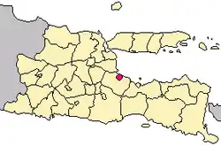 Location within East Java | |
| Coordinates: 7°38′26.24″S 112°54′23.32″E | |
| Country | Indonesia |
| Province | East Java |
| Government | |
| • Mayor | Saifullah Yusuf |
| • Vice Mayor | Adi Wibowo |
| Area | |
| • Total | 38.99 km2 (15.05 sq mi) |
| Population (mid 2022 estimate) | |
| • Total | 211,497 |
| • Density | 5,400/km2 (14,000/sq mi) |
| Time zone | UTC+7 (IWST) |
| Area code | (+62) 343 |
| Website | pasuruankota.go.id |

It is surrounded by, but is administratively separate from, Pasuruan Regency. It is located around 65 kilometres southeast of Surabaya.
_te_Pasoeroean%252C_KITLV_116766.tiff.jpg.webp)
Administrative districts
Pasuruan is divided into four districts (kecamatan), tabulated below with their areas and their populations at the 2010[1] and 2020[2] Censuses, together with the official estimates as at mid 2022.[3] The table also includes the locations of the district administrative centres, the number of administrative villages (urban kelurahan) in each district, and its postal codes.
| Name of District (kecamatan) | Area in km2 | Pop'n Census 2010 | Pop'n Census 2020 | Pop'n Estimate mid 2022 | Admin centre | No. of villages | Post codes |
|---|---|---|---|---|---|---|---|
| Gadingrejo | 8.27 | 62,401 | 49,442 | 50,785 | Gadingrejo | 8 | 67134 - 67139 |
| Purworejo | 8.08 | 66,647 | 62,007 | 63,787 | Kebonagung | 7 | 67115 - 67118 (a) |
| Bungulkidul | 11.11 | 57,214 | 31,687 | 32,274 | Bugulkidul | 6 | 67127 - 67129 |
| Panggungrejo | 7.83 | (b) | 64,870 | 64,651 | Ngemplakrejo | 13 | 67111 - 67114, 67123 - 67129, 67131 - 67133 |
| Totals | 35.29 | 186,262 | 208,006 | 211,487 | Panggungrejo | 34 |
Note: (a) except Sekargadung kelurahan (which has a postcode of 67127) and Pohjentrek kelurahan (which has a postcode of 67171).
(b) Panggungrejo District created since 2010 from parts of neighbouring districts; its population in 2010 is included with that of the districts from which it was formed.
Climate
Pasuruan has a tropical savanna climate (Aw) with little to no rainfall from May to November and heavy rainfall from December to April.
| Climate data for Pasuruan | |||||||||||||
|---|---|---|---|---|---|---|---|---|---|---|---|---|---|
| Month | Jan | Feb | Mar | Apr | May | Jun | Jul | Aug | Sep | Oct | Nov | Dec | Year |
| Average high °C (°F) | 32.3 (90.1) |
32.0 (89.6) |
32.0 (89.6) |
32.0 (89.6) |
31.9 (89.4) |
31.9 (89.4) |
31.8 (89.2) |
32.4 (90.3) |
32.8 (91.0) |
33.5 (92.3) |
33.3 (91.9) |
32.6 (90.7) |
32.4 (90.3) |
| Daily mean °C (°F) | 27.4 (81.3) |
27.3 (81.1) |
27.1 (80.8) |
27.0 (80.6) |
26.5 (79.7) |
25.9 (78.6) |
25.3 (77.5) |
25.8 (78.4) |
26.4 (79.5) |
27.2 (81.0) |
27.7 (81.9) |
27.3 (81.1) |
26.7 (80.1) |
| Average low °C (°F) | 22.5 (72.5) |
22.6 (72.7) |
22.3 (72.1) |
22.0 (71.6) |
21.1 (70.0) |
19.9 (67.8) |
18.9 (66.0) |
19.3 (66.7) |
20.0 (68.0) |
21.0 (69.8) |
22.1 (71.8) |
22.1 (71.8) |
21.2 (70.1) |
| Average rainfall mm (inches) | 239 (9.4) |
259 (10.2) |
202 (8.0) |
139 (5.5) |
92 (3.6) |
61 (2.4) |
19 (0.7) |
2 (0.1) |
9 (0.4) |
20 (0.8) |
81 (3.2) |
188 (7.4) |
1,311 (51.7) |
| Source: Climate-Data.org[4] | |||||||||||||
Public transport
Pasuruan located and connected by provincial main road between Surabaya―Banyuwangi. Pasuruan can be reached from Surabaya by bus or local commuter train, which took at least 2 hours. And also, can be reached from Malang by bus or car that took at least 1.3 hours. This town linked with other cities by Trans Java Freeway.
The city has an active railway station as a stop for intercity trains and local commuter from Surabaya Kota. To the west before Bangil railway station there's Kraton railway station which is inactive today due to close range from Pasuruan station. In the past, this city had the local steam tram company named Pasoeroean Stoomtram Maatschappij served from 1896 to 1969. This train served as passenger transport as well as freight transport of agricultural products such as sugarcane, tea and tobacco.
Sister cities
References
- Biro Pusat Statistik, Jakarta, 2011.
- Badan Pusat Statistik, Jakarta, 2021.
- Badan Pusat Statistik, Jakarta, 2023, Kota Pasuruan Dalam Angka 2023 (Katalog-BPS 1102001.3575)
- "Climate: Pasuruan". Climate-Data.org. Retrieved 15 November 2020.
External links
- http://www.accuweather.com/id/id/pasuruan/203183/daily-weather-forecast/203183?day=2
- https://www.meteoblue.com/en/weather/forecast/modelclimate/pasuruan_indonesia_1632033
- Pasuruan Info

| 2,000,000 and more | |
|---|---|
| 1,000,000–1,999,999 | |
| 500,000–999,999 | |
| 300,000–499,999 | |
| 200,000–299,999 | |