Pennsylvania statistical areas

The United States Commonwealth of Pennsylvania currently has 49 statistical areas that have been delineated by the Office of Management and Budget (OMB). On March 6, 2020, the OMB delineated 12 combined statistical areas, 20 metropolitan statistical areas, and 17 micropolitan statistical areas in Pennsylvania.[1]
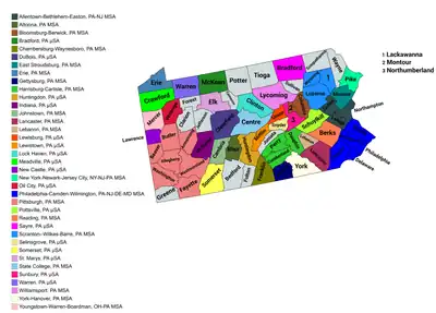
Map of the 37 core-based statistical areas in Pennsylvania
An enlargeable map of the 37 core-based statistical areas in Pennsylvania[1]

Statistical areas

The Office of Management and Budget (OMB) has designated more than 1,000 statistical areas for the United States and Puerto Rico.[2] These statistical areas are important geographic delineations of population clusters used by the OMB, the United States Census Bureau, planning organizations, and federal, state, and local government entities.

The OMB defines a core-based statistical area (commonly referred to as a CBSA) as "a statistical geographic entity consisting of the county or counties (or county-equivalents) associated with at least one core[lower-alpha 1] of at least 10,000 population, plus adjacent counties having a high degree of social and economic integration with the core as measured through commuting ties with the counties containing the core."[2] The OMB further divides core-based statistical areas into metropolitan statistical areas (MSAs) that have "a population of at least 50,000" and micropolitan statistical areas (μSAs) that have "a population of at least 10,000, but less than 50,000."[2]

The OMB defines a Combined statistical area (CSA) as "a geographic entity consisting of two or more adjacent core-based statistical areas with employment interchange measures[lower-alpha 2] of at least 15%."[2] The primary statistical areas (PSAs) include all combined statistical areas and any core-based statistical area that is not a constituent of a combined statistical area.

Table

The table below describes the 49 United States statistical areas and 67 counties of the Commonwealth of Pennsylvania with the following information:[3]

  1. The combined statistical area (CSA) as designated by the OMB.[1]
  2. The CSA population according to 2019 US Census Bureau population estimates.[4]
  3. The core based statistical area (CBSA)[2] as designated by the OMB.[1]
  4. The CBSA population according to 2019 US Census Bureau population estimates [4]
  5. The county name
  6. The county population according to 2019 US Census Bureau population estimates [4]
  7. The Metropolitan Division name, if applicable[1]
  8. The Metropolitan Division population according to 2019 US Census Bureau population estimates [4]
The 49 United States statistical areas and 67 counties of the Commonwealth of Pennsylvania

Combined Statistical Area 2019 Population Core Based Statistical Area 2019 Population County 2019 Population Metropolitan Division 2019 Population
Philadelphia-Camden-Vineland, PA-NJ-DE-MD CSA 7,209,620
4,556,149
Philadelphia-Camden-Wilmington, PA-NJ-DE-MD MSA 6,102,434
4,134,985
Philadelphia County, Pennsylvania 1,584,064 Philadelphia, PA MD 2,150,811
Delaware County, Pennsylvania 566,747
Montgomery County, Pennsylvania 830,915 Montgomery County-Chester County-Bucks County, PA MD 1,984,174
Bucks County, Pennsylvania 628,270
Chester County, Pennsylvania 524,989
Camden County, New Jersey 506,471 Camden, NJ MD 1,243,456
Burlington County, New Jersey 445,349
Gloucester County, New Jersey 291,636
New Castle County, Delaware 558,753 Wilmington, DE-MD-NJ MD 723,993
Cecil County, Maryland 102,855
Salem County, New Jersey 62,385
Reading, PA MSA 421,164 Berks County, Pennsylvania 421,164 none
Atlantic City-Hammonton, NJ MSA 263,670 Atlantic County, New Jersey 263,670
Dover, DE MSA 180,786 Kent County, Delaware 180,786
Vineland-Bridgeton, NJ MSA 149,527 Cumberland County, New Jersey 149,527
Ocean City, NJ MSA 92,039 Cape May County, New Jersey 92,039
Pittsburgh-New Castle-Weirton, PA-OH-WV CSA 2,603,259
2,487,185
Pittsburgh, PA MSA 2,317,600 Allegheny County, Pennsylvania 1,216,045
Westmoreland County, Pennsylvania 348,899
Washington County, Pennsylvania 206,865
Butler County, Pennsylvania 187,853
Beaver County, Pennsylvania 163,929
Fayette County, Pennsylvania 129,274
Armstrong County, Pennsylvania 64,735
Weirton-Steubenville, WV-OH MSA 116,074 Jefferson County, Ohio 65,325
Hancock County, West Virginia 28,810
Brooke County, West Virginia 21,939
New Castle, PA μSA 85,512 Lawrence County, Pennsylvania 85,512
Indiana, PA μSA 84,073 Indiana County, Pennsylvania 84,073
Harrisburg–York–Lebanon, PA CSA 1,271,801 Harrisburg-Carlisle, PA MSA 577,941 Dauphin County, Pennsylvania 278,299
Cumberland County, Pennsylvania 253,370
Perry County, Pennsylvania 46,272
York-Hanover, PA MSA 449,058 York County, Pennsylvania 449,058
Lebanon, PA MSA 141,793 Lebanon County, Pennsylvania 141,793
Gettysburg, PA MSA 103,009 Adams County, Pennsylvania 103,009
none Allentown-Bethlehem-Easton, PA-NJ MSA|Allentown-Bethlehem-Easton, PA-NJ MSA 844,052
738,785
Lehigh County, Pennsylvania 369,318
Northampton County, Pennsylvania 305,285
Warren County, New Jersey 105,267
Carbon County, Pennsylvania 64,182
Scranton-Wilkes-Barre, PA MSA 553,885 Luzerne County, Pennsylvania 317,417
Lackawanna County, Pennsylvania 209,674
Wyoming County, Pennsylvania 26,794
Lancaster, PA MSA 545,724 Lancaster County, Pennsylvania 545,724
Erie-Meadville, PA CSA 354,357 Erie, PA MSA 269,728 Erie County, Pennsylvania 269,728
Meadville, PA Micropolitan Statistical Area 84,629 Crawford County, Pennsylvania 84,629
Bloomsburg-Berwick-Sunbury, PA CSA 259,332 Sunbury, PA μSA 90,843 Northumberland County, Pennsylvania 90,843
Bloomsburg-Berwick, PA MSA 83,194 Columbia County, Pennsylvania 64,964
Montour County, Pennsylvania 18,230
Lewisburg, PA μSA 44,923 Union County, Pennsylvania 44,923
Selinsgrove, PA μSA 40,372 Snyder County, Pennsylvania 40,372
State College-DuBois, PA CSA 241,640 State College, PA MSA 162,385 Centre County, Pennsylvania 162,385
DuBois, PA μSA 79,255 Clearfield County, Pennsylvania 79,255
New York-Newark, NY-NJ-CT-PA CSA 22,589,036
226,080
New York-Newark-Jersey City, NY-NJ-PA MSA 19,216,182
55,809
Kings County, New York 2,559,903 New York-Jersey City-White Plains, NY-NJ MD 11,834,851
Queens County, New York 2,253,858
New York County, New York 1,628,706
Bronx County, New York 1,418,207
Westchester County, New York 967,506
Bergen County, New Jersey 932,202
Hudson County, New Jersey 672,391
Passaic County, New Jersey 501,826
Richmond County, New York 476,143
Rockland County, New York 325,789
Putnam County, New York 98,320
Suffolk County, New York 1,476,601 Nassau County-Suffolk County, NY MD 2,833,525
Nassau County, New York 1,356,924
Middlesex County, New Jersey 825,062 New Brunswick-Lakewood, NJ MD 2,379,977
Monmouth County, New Jersey 618,795
Ocean County, New Jersey 607,186
Somerset County, New Jersey 328,934
Essex County, New Jersey 798,975 Newark, NJ-PA MD 2,167,829
55,809
Union County, New Jersey 556,341
Morris County, New Jersey 491,845
Sussex County, New Jersey 140,488
Hunterdon County, New Jersey 124,371
Pike County, Pennsylvania 55,809
Bridgeport-Stamford-Norwalk, CT MSA 943,332 Fairfield County, Connecticut 943,332 none
New Haven-Milford, CT MSA 854,757 New Haven County, Connecticut 854,757
Poughkeepsie-Newburgh-Middletown, NY MSA 679,158 Orange County, New York 384,940
Dutchess County, New York 294,218
Trenton-Princeton, NJ MSA 367,430 Mercer County, New Jersey 367,430
Torrington, CT μSA 180,333 Litchfield County, Connecticut 180,333
Kingston, NY MSA 177,573 Ulster County, New York 177,573
East Stroudsburg, PA MSA 170,271 Monroe County, Pennsylvania 170,271
Johnstown-Somerset, PA CSA 203,639 Johnstown, PA MSA 130,192 Cambria County, Pennsylvania 130,192
Somerset, PA μSA 73,447 Somerset County, Pennsylvania 73,447
Altoona-Huntingdon, PA CSA 166,973 Altoona, PA MSA 121,829 Blair County, Pennsylvania 121,829
Huntingdon, PA μSA 45,144 Huntingdon County, Pennsylvania 45,144
Washington-Baltimore-Arlington, DC-MD-VA-WV-PA CSA 9,814,928
155,027
Washington-Arlington-Alexandria, DC-VA-MD-WV MSA 6,280,487 Fairfax County, Virginia 1,147,532 Washington-Arlington-Alexandria, DC-VA-MD-WV MD 4,970,252
Prince George's County, Maryland 909,327
District of Columbia 705,749
Prince William County, Virginia 470,335
Loudoun County, Virginia 413,538
Arlington County, Virginia 236,842
Charles County, Maryland 163,257
City of Alexandria, Virginia 159,428
Stafford County, Virginia 152,882
Spotsylvania County, Virginia 136,215
Calvert County, Maryland 92,525
Fauquier County, Virginia 71,222
Jefferson County, West Virginia 57,146
Culpeper County, Virginia 52,605
City of Manassas, Virginia 41,085
Warren County, Virginia 40,164
City of Fredericksburg, Virginia 29,036
City of Fairfax, Virginia 24,019
City of Manassas Park, Virginia 17,478
Clarke County, Virginia 14,619
City of Falls Church, Virginia 14,617
Madison County, Virginia 13,261
Rappahannock County, Virginia 7,370
Montgomery County, Maryland 1,050,688 Frederick-Gaithersburg-Rockville, MD MD 1,310,235
Frederick County, Maryland 259,547
Baltimore-Columbia-Towson, MD MSA 2,800,053 Baltimore County, Maryland 827,370 none
Baltimore City, Maryland 593,490
Anne Arundel County, Maryland 579,234
Howard County, Maryland 325,690
Harford County, Maryland 255,441
Carroll County, Maryland 168,447
Queen Anne's County, Maryland 50,381
Hagerstown-Martinsburg, MD-WV MSA 288,104 Washington County, Maryland 151,049
Berkeley County, West Virginia 119,171
Morgan County, West Virginia 17,884
Chambersburg-Waynesboro, PA MSA 155,027 Franklin County, Pennsylvania 155,027
Winchester, VA-WV MSA 140,566 Frederick County, Virginia 89,313
City of Winchester, Virginia 28,078
Hampshire County, West Virginia 23,175
California–Lexington Park, MD μSA 113,510 St. Mary's County, Maryland 113,510
Easton, MD μSA 37,181 Talbot County, Maryland 36,968
Williamsport-Lock Haven, PA CSA 152,348 Williamsport, PA MSA 113,664 Lycoming County, Pennsylvania 113,664
Lock Haven, PA μSA 38,684 Clinton County, Pennsylvania 38,684
none Pottsville MSA 141,359 Schuylkill County, Pennsylvania 141,359
Youngstown-Warren, OH-PA CSA 637,964
109,424
Youngstown-Warren-Boardman, OH-PA MSA 536,081
109,424
Mahoning County, Ohio 228,683
Trumbull County, Ohio 197,974
Mercer County, Pennsylvania 109,424
Salem, OH μSA 101,883 Columbiana County, Ohio 101,883
none Sayre, PA μSA 60,323 Bradford County, Pennsylvania 60,323
Oil City, PA μSA 50,668 Venango County, Pennsylvania 50,668
Lewistown, PA μSA 46,138 Mifflin County, Pennsylvania 46,138
Bradford, PA μSA 40,625 McKean County, Pennsylvania 40,625
Warren, PA μSA 39,191 Warren County, Pennsylvania 39,191
St. Marys, PA μSA 29,910 Elk County, Pennsylvania 29,910
none Wayne County, Pennsylvania 51,361
Bedford County, Pennsylvania 47,888
Jefferson County, Pennsylvania 43,425
Tioga County, Pennsylvania 40,591
Susquehanna County, Pennsylvania 40,328
Clarion County, Pennsylvania 38,438
Greene County, Pennsylvania 36,233
Juniata County, Pennsylvania 24,763
Potter County, Pennsylvania 16,526
Fulton County, Pennsylvania 14,530
Forest County, Pennsylvania 7,247
Sullivan County, Pennsylvania 6,066
Cameron County, Pennsylvania 4,447
Commonwealth of Pennsylvania 12,802,406

See also

Notes

  1. The OMB defines a core as "a densely settled concentration of population, comprising an Urban Area (of 10,000 or more population) delineated by the Census Bureau, around which a core-based statistical area is delineated."[2]
  2. The OMB defines the employment interchange measure as "the sum of the percentage of workers living in the smaller entity who work in the larger entity plus the percentage of employment in the smaller entity that is accounted for by workers who reside in the larger entity."[2]

References

  1. Revised Delineations of Metropolitan Statistical Areas, Micropolitan Statistical Areas, and Combined Statistical Areas, and Guidance on Uses of the Delineations of These Areas (March 6, 2020). "0MB BULLETIN NO. 20-01" (PDF). Office of Management and Budget. Retrieved December 15, 2021.{{cite web}}: CS1 maint: multiple names: authors list (link)
  2. "2020 Standards for Delineating Core Based Statistical Areas". Office of Management and Budget. July 16, 2021. Retrieved December 15, 2021.
  3. An out-of-state area and its population are displayed in green. An area that extends into more than one state is displayed in teal. A teal population number over a black population number show the total population versus the in-state population.
  4. "Annual Estimates of the Resident Population for Counties in the United States: April 1, 2010 to July 1, 2019". United States Census Bureau, Population Division. April 2020. Retrieved April 9, 2020.

40.8781°N 77.7996°W / 40.8781; -77.7996 (Commonwealth of Pennsylvania)

This article is issued from Wikipedia. The text is licensed under Creative Commons - Attribution - Sharealike. Additional terms may apply for the media files.