Pherzawl district
Pherzawl district (Meitei pronunciation:/ˌpherˈzâwl/[lower-alpha 1][1]) is a district of Manipur state in India.
Pherzawl district | |
|---|---|
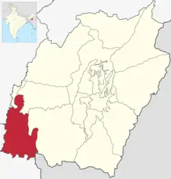 Location in Manipur | |
| Coordinates (Pherzawl): 24°15′N 93°11′E | |
| Country | |
| State | Manipur |
| Established | 2016 |
| Headquarters | Pherzawl |
| Area | |
| • Total | 2,178 km2 (841 sq mi) |
| Population | |
| • Total | 47,259 |
| • Density | 22/km2 (56/sq mi) |
| Demographics | |
| • Literacy | 69.03% |
| Language(s) | |
| • Official | Meitei (officially called Manipuri)[lower-alpha 1][1] |
| • Regional | Hmar Ṭawng, and other Chin-Kuki-Mizo Ṭawng |
| Time zone | UTC+05:30 (IST) |
| Vehicle registration | MN0 |
| Major highways | NH-150, NH-2 |
| Website | pherzawl |
Location and politics
Pherzawl District is located in the southern part of the state of Manipur. It is bounded on the east by Churachandpur District; on the north by Tamenglong District, Noney District and Jiribam district; on the west by the Cachar District of Assam and on the South by Sinlung Hills, Mizoram. Pherzawl District is located between 93° 11' 16.0440' East Longitude and 24° 15' 43.0524' North Latitude and is in the southern part of Manipur state. Pherzawl District has approximately 200 villages, according to the government's record.
The Pherzawl District came into existence on 8 December 2016 by joining 55-AC Tipaimukh (ST) and 56-AC Thanlon (ST) with its headquarters at Pherzawl. Despite the controversy surrounding the creation of seven new revenue districts in Manipur, the people of Pherzawl District welcomed the decision with celebrations[2] on 16 December 2016, when Manipur Chief Minister Okram Ibobi Singh inaugurated the administrative centre at Pherzawl village.
Transport
Pherzawl is connected with the state capital Imphal via roads. A bus service running between Imphal and Pherzawl began in 2017.[3]
Climate and geography
The district is under humid subtropical climate. The soil is moderately fertile with clay loam soil with little patches of clay and loam. The temperature ranges from a minimum of 3.4 °C (38.1 °F) to a maximum of 34.1 °C (93.4 °F). The annual rainfall ranges from 670 to 1,450 mm (26 to 57 in). The elevation of the District is 1037 meters, or 3,402 feet.
Languages
Notes
- Meitei language (officially known as Manipuri language) is the official language of Manipur. Other regional languages of different places in Manipur may either be predominantly spoken or not in their respective places but "Meitei" is always officially used.
References
- "Report of the Commissioner for linguistic minorities: 47th report (July 2008 to June 2010)" (PDF). Commissioner for Linguistic Minorities, Ministry of Minority Affairs, Government of India. p. 78. Archived from the original (PDF) on 13 May 2012. Retrieved 16 February 2012.
- "Pherzawl District Inauguration (Night Programme)". YouTube. 20 December 2016. Retrieved 8 May 2019.
- "First view of Pherzawl Bus from Imphal; Long Vehicle Pragmatic for Hill Areas? – Zoram Observer". www.zoramobserver.com. Archived from the original on 2 August 2018. Retrieved 12 January 2022.
- "C-1 Population By Linguistic Community". Census. Archived from the original on 13 September 2015. Retrieved 10 June 2019.
External links
Places adjacent to Pherzawl district | ||||||||||||||||
|---|---|---|---|---|---|---|---|---|---|---|---|---|---|---|---|---|
| ||||||||||||||||