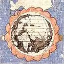
Piri Reis map
The Piri Reis map is a world map compiled in 1513 by the Ottoman admiral and cartographer Piri Reis. Approximately one third of the map survives, housed in the Topkapı Palace in Istanbul. When rediscovered in 1929, the remaining fragment garnered international attention as it includes a partial copy of an otherwise lost map by Christopher Columbus.

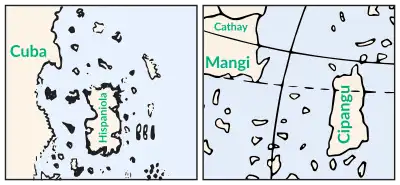
The map is a portolan chart with compass roses and a windrose network for navigation, rather than lines of longitude and latitude. It contains extensive notes primarily in Ottoman Turkish. The depiction of South America is detailed and accurate for its time. Scholars attribute the peculiar arrangement of the Caribbean to a now-lost map from Columbus that depicted Cuba as part of the Asian mainland and Hispaniola according to Marco Polo's description of Japan. The southern coast of the Atlantic Ocean is widely accepted to be a version of Terra Australis.
The map is visually distinct from European portolan charts, populated by Islamic miniatures. The map was unusual in the Islamic cartographic tradition for incorporating many non-Muslim sources. Historian Karen Pinto has described the combination of legendary creatures from the edge of the known world with positive portrayals as challenging the medieval Islamic idea of an "inhabited quarter" of the world surrounded by an impassable Encircling Ocean.
There are conflicting interpretations of the map. Scholarly debate exists over the specific sources used in the map's creation and the number of source maps. Many areas on the map have not been conclusively identified with real or mythical places. Some authors have noted visual similarities to parts of the Americas not officially discovered by 1513, but there is no textual or historical evidence that the map represents land south of present-day Cananéia. A disproven 20th-century hypothesis identified the southern landmass with an ice-free Antarctic coast.
History
Much of Piri Reis's life is known only from his cartographic works, including his two world maps and the Kitab-ı Bahriye (Book of Maritime Matters).[1] He sailed with his uncle Kemal Reis,[2] as Barbary pirates until Kemal Reis received an official position in the Ottoman navy in 1494.[3] In one naval battle, they captured a Spaniard from Columbus's voyages,[4] who likely possessed a map from Columbus that Piri Reis would soon use as one of his sources.[lower-alpha 1] When his uncle died in 1511, Piri Reis temporarily retired to Gallipoli and began composing his first world map.[5] The finished manuscript was dated to the month of Muharram in the Islamic year 919 AH, equivalent to 1513 AD.[6] Piri Reis returned to the navy and played a role in the 1517 conquest of Egypt. After the victory,[7] Piri Reis presented the 1513 world map to Ottoman Sultan Selim I.[lower-alpha 2] It is unknown how Selim used the map, if at all, as it would vanish from history until its rediscovery centuries later.[8]
A fragment of the map was unearthed in late 1929.[9] The Topkapı Palace was being converted into a museum, and Director of National Museums Dr. Halil Edhem Eldem invited German theologian Gustav Adolf Deissmann to tour its library.[10] Deissmann persuaded the Rockefeller Foundation to fund a project to preserve ancient manuscripts from the library.[lower-alpha 3] Halil Edhem gave Deissmann unprecedented access to the library's collection of non-Islamic items.[lower-alpha 4] Deissmann confirmed the collection to have been the vast private library of Mehmed II and—based on Mehmed II's interest in geography—asked Halil Edhem to search for potentially overlooked maps. Halil Edhem located a disregarded bundle of material containing an unusual parchment map.[11] They showed the parchment to the orientalist Paul E. Kahle, who identified the map as a creation of Piri Reis using source maps from Colombus's voyages to the Americas.[12] The discovery caused an international sensation because it contains the only surviving piece of an otherwise lost map of Christopher Columbus.[13][14] Turkey's first president Mustafa Kemal Atatürk took an interest in the map and initiated projects to publish copies and conduct further research.[15]
Description
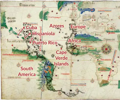
Kept in the Topkapı Palace Museum,[16] the map is the remaining western third of a world map drawn on gazelle-skin parchment approximately 87 cm × 63 cm.[lower-alpha 5] The surviving portion shows the Atlantic Ocean with the coasts of Europe, Africa, and South America.[17] The map is a portolan chart, as shown by the compass roses from which lines of bearing radiate. Designed for navigation, portolan charts use a windrose network rather than a longitude and latitude grid.[18] There are extensive notes within the map.[18] Written with the Arabic alphabet, the inscriptions are in Ottoman Turkish except for the colophon.[19]
Places
The remaining third of the map focuses on the Atlantic and the Americas.[20] In the top left corner, the Caribbean is arranged unlike modern or contemporary maps.[21] The large island oriented vertically is labeled Hispaniola,[22] and the western coast includes elements of Cuba and Central America.[23] Inscriptions along both South America and the Southern Continent cite recent Portuguese voyages.[24] The distance between Brazil and Africa is roughly correct,[25] and the Atlantic islands are drawn consistent with the portolan charts of Europe.[26]
Many places on the map have been identified as phantom islands or have not been identified conclusively. İle Verde (Green Island) north of Hispaniola could refer to any number of islands.[27][lower-alpha 6] The large island in the Atlantic, İzle de Vaka (Ox island), corresponds to no known real or fictional island.[28] Both an Atlantic island and the mainland of the Americas are referred to as the legendary Antilia.[29][lower-alpha 7]
Sources
According to the map's legend,[30] it was based on:
- Twenty charts and Mappae Mundi
- Eight Jaferiyes (Geographia or Jughrafiya)[31]
- An Arabic map of India
- Four newly drawn Portuguese maps of Asia[31]
- A map by Christopher Columbus of the West Indies[32]
There is some scholarly debate over the various sources.[33] In the modern sense, mappae mundi refer to medieval Christian schematic maps of the world. In the fifteenth century, the term was also literally used to describe world maps, and it is possible the source maps fit in that broader definition.[34] The Jaferiyes are seen by scholars as a corruption of the Arabic Jughrafiya, most often taken to mean the Geographia of Claudius Ptolemy. They may also refer to the largely symbolic world maps of medieval Islamic cartography.[35] Descended from classical scholarship,[36] these treatises sometimes used the loanword jughrafiya in their titles.[37] The Arabic and the four Portuguese source maps have not been conclusively identified but have been associated with several notable maps of the period. Finally, there is debate on the total number of source documents. Some scholars interpret the "20 charts and mappae mundi" in the inscriptions as including the other maps, and others interpret them to mean a total of 30 or 34.[38]
Analysis
Compared to the Islamic cartography of the era, the map shows an atypical knowledge of foreign discoveries.[40] During the Age of Discovery, European voyages expanded the known world and disrupted the traditional Islamic conception of an "inhabited quarter" of the world comparable to the Greek ecumene.[41] The attitudes towards the Age of Discovery within the Ottoman Empire ranged from passive indifference to the outright rejection of foreign influence.[42]
Piri Reis synthesizes traditional worldviews with discoveries by undermining their newness. He invokes Dhu al-Qarnayn—believed to be a reference to Alexander the Great from the Quran—in his inscriptions regarding Columbus.[43] According to the Quran and Turkish literary tradition, Alexander traveled to every corner of the world, thereby defining its limits.[44] A marginal inscription describes world maps as "charts drawn in the days of Alexander".[45] Another inscription mentions that a "book fell into the hands" of Columbus describing lands "at the end of the Western Sea".[46] This reframes Columbus's voyage from a European discovery to the rediscovery of ancient knowledge.[47] In Piri Reis' later Book of Sea Lore (1526), he explicitly credits European discoveries to lost works created during legendary voyages of Alexander.[lower-alpha 8]
Compared to earlier portolan charts, the map shows gradual improvement.[19] Portuguese source maps would have been similar to surviving maps like the 1502 Cantino Planisphere.[48] Compared to the planisphere and the map of Juan de la Cosa (1500), the Atlantic Ocean is accurate, South America is highly detailed, and the Caribbean is strangely organized, due to using a Colombian source map.[49] As a part of the expanding cartography of the sixteenth century, the map was soon surpassed.[50] A 1528 world map created by Piri Reis himself included a more accurate Caribbean.[51] Despite recent claims of an anomalous level of accuracy,[lower-alpha 9] Gregory McIntosh, in comparing it to several other portolan-style maps of the era, found that:
The Piri Reis map is not the most accurate map of the sixteenth century, as has been claimed, there being many, many world maps produced in the remaining eighty-seven years of that century that far surpass it in accuracy. The Ribeiro maps of the 1520s and 1530s, the Ortelius map of 1570, and the Wright-Molyneux map of 1599 ('the best map of the sixteenth century') are only a few better-known examples.[52]
Iconography
Piri Reis's inclusion of many foreign accounts was atypical within the Ottoman Empire.[53] After the conquest of Constantinople, Sultan Mehmed II began a project of creating copies of traditional Islamic maps in the Book of Roads and Kingdoms tradition.[lower-alpha 11] Piri Reis adapted the elements of iconography from the traditional maps—which illustrated routes, cities, and peoples within the Islamic world—to the portolan portrayals of newly discovered coasts. Where European maps placed portraits and flags in the lands across the ocean, Piri Reis placed mountains and monsters.[54]
Piri Reis provides a strange etymology of "Ocean" as coming from "Ovo Sano", or "sound egg".[55] The accepted etymology comes from the world-encircling river, Oceanus. Historian Svat Soucek has described the egg etymology as naive.[56] Historian Karen Pinto has proposed that the egg etymology is better understood in the context of traditional attitudes towards the deep seas in Islamic culture. Most previous Islamic world maps followed a standardized and schematic design, with a disc-shaped "inhabited quarter" of the world separated from Mount Qaf by an impassable Encircling Ocean.[57] Pinto observed that Piri Reis had reconciled the discovery of new land beyond the sea with this existing model, by framing the Old World—ocean included—as a giant lake surrounded by the shores of the New World. The Ottoman miniatures that illuminate the map can be further interpreted in the context of new possibilities and the changing cultural landscape.[58]
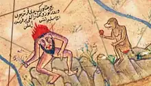
The Western fringe of the map is populated by a variety of strange monsters from medieval mappaemundi and bestiaries.[59] Among the mountains in South America, a headless man is depicted interacting with a monkey. The headless men, known as Blemmyes, were portrayed in medieval maps and books as threatening. In Islamic culture, monkeys were considered ill omens.[60] The caption states that despite the monsters' appearance, they "are harmless souls,"[61] which contrasts with previous depictions of both the headless men and the edge of the known world.[54] Pinto characterized the map's monsters as, "a distinct break with earlier, and in fact, co-terminus manuscript traditions, which enforce and reinforce the notion that the Encircling Ocean is full of scary beasts and therefore should not be crossed."[62] In addition to the Blemmye, several other creatures from Natural History by Pliny the Elder[lower-alpha 12] inhabit the Americas. The dog-faced man shown dancing with a monkey is one of the cynocephaly; a monoceros and yale are shown on the South American coast; and a bonnacon is shown on the Southern Continent.[63] The multi-horned beast on the bottom edge of the map is the legendary shadhavar, which emits music when the wind blows through its hollow horns.[64]
Caribbean
The Caribbean islands and the coastline in the Northwest corner of the map are widely believed to be based on a lost map drawn by Christopher Columbus, or under his supervision. The western coast on the map combines features of Central America and Cuba, reflecting Columbus's claim that Cuba was part of an Asian "mainland".[65] During the 1494 exploration of Cuba, Columbus was so adamant that he had found Asia,[lower-alpha 13] that he had a notary board each of his ships anchored off the coast. Columbus compelled his men to swear that Cuba was a part of Asia and agree to never contradict this interpretation "under a penalty of 10,000 maravedis and the cutting out of the tongue".[66][lower-alpha 14] Placenames are directly connected to Columbus. For example, an area on Cuba's coast references Ornofay, a native placename recorded by Columbus and depicted on no other maps.[lower-alpha 15]
Peculiar features of the Caribbean can be attributed to Columbus. Notably, a massive Hispaniola is oriented north to south. Columbus traveled West with a chart from Paolo dal Pozzo Toscanelli that—directly west of the Cape Verde Islands—showed open ocean, mythical Antilia, and Cipangu (Marco Polo's Japan) between Europe and the Indes. The general position and rectangular shape of Hispaniola are similar to contemporary maps of Cipangu.[67] The absence of the island's distinctive Gulf of Gonâve is more evidence of a Columbian origin, as none of his voyages explored the western shore.[68] The peninsulas protruding from Puerto Rico are not present in reality but are also depicted on the map of Juan de la Cosa, who sailed with Columbus.[69] İle Bele near Puerto Rico is possibly Vieques, named Gratiosa, or Graceful, by Columbus.[70]
Southern Continent
The Southern Continent stretching across the Atlantic Ocean is most likely Terra Australis. Some authors have claimed that it depicts areas of South America not officially discovered in 1513, and a popular but disproven hypothesis alleges it to be Antarctica.[71] Maps of the period generally depicted a large Southern continent highly variable in shape and extent.[72] This land was posited by Roman geographer Ptolemy as a counterbalance to the extensive land areas in the known world.[lower-alpha 16]
As explorers charted the Southern Hemisphere, it pushed back the potential bounds of Terra Australis.[73] Discoveries, like Tierra del Fuego and New Holland,[74] were initially mapped as the northern edge of the unknown southern land. As these areas were mapped, Terra Australis shrank, grew vague, and became a fantastical locale invoked in literature, notably Gulliver's Travels and Gabriel de Foigny's La Terre Australe Connue.[75] Belief in the Southern Continent was abandoned after the second voyage of James Cook in the 1770s showed that if it existed, it was much smaller than imagined previously. The first confirmed landing on Antarctica was only during the First Russian Antarctic Expedition in 1820, and the coastline of Queen Maud Land did not see significant exploration before Norwegian expeditions began in 1891.[76]
South American claims
The southernmost conclusively identified feature on the map is a stretch of coastline including Cabo Frio (Kav Friyo on the map), possibly the earliest depiction of Rio de Janeiro, and likely the area around Cananéia, labeled Katino on the map.[77] Information about this area is attributed to recent Portuguese voyages,[78] and the southernmost point depicted on contemporary Portuguese maps was Cananéia as described by Amerigo Vespucci, at 25 degrees south.[77] Beyond this point, the coast curves sharply east. Some modern writers have interpreted this coastline as the coast of South America, either drawn along the map's edge or distorted to push it East of the line of demarcation. Cartographic historian Svat Soucek noted that the parchment curves by South America, and that "it was not unusual for cartographers to adjust the orientation of a coastline to fit the surface available".[79] Italian art historian and graphic designer Diego Cuoghi said that "Piri Reis often mentions Portuguese maps in his notes, and of course Portuguese would have preferred the coast south of Brazil to bend sharply to the right".[80] This identification relies on perceived visual similarities between the map and modern maps of the Río de la Plata, San Matías Gulf, Valdés Peninsula, and Strait of Magellan's Atlantic opening.[81] Aside from the subjective comparisons, there is no historical evidence that Piri Reis could have known of these places and no textual evidence in the map.[19] In particular, the large snakes like those of the Boidae family mentioned on the map,[82] are not found that far south in Patagonia.[83]
Antarctic claims

The Antarctic claim originates with Captain Arlington H. Mallery, a civil engineer and amateur archaeologist who was a supporter of pre-Columbian trans-oceanic contact hypotheses. Mallery used a grid system to reposition the coordinates on the map and claimed the accuracy of his new "corrected" maps to be comparable to maps made using aerial photography.[84][lower-alpha 17] Mallery's ideas were exposed to a wider audience when Georgetown University broadcast a discussion between Mallery, director of the Weston Observatory Daniel Lineham, and director of the Georgetown University Observatory Francis Heyden in 1956.[85] Inspired by Mallery, historian Charles Hapgood, in his 1966 book Maps of the Ancient Sea Kings, proposed a theory of global exploration by a pre-classical undiscovered civilization based on his analysis of ancient and late-medieval maps.[86] Hapgood's book was met with skepticism due to its lack of evidence and reliance on polar shift.[87][lower-alpha 18] Hapgood acknowledged that his theory disregarded the text and some of the placement of land masses on the map. For example, he designated an island to be one-half of Cuba—claiming it was "wrongly labeled Espaniola" or Hispaniola—and remarked that, "nothing could better illustrate how ignorant Piri Re'is was of his own map."[88]
Hapgood, and his graduate students who aided with the research, were influential in spreading the idea that the Piri Reis map shows Antarctica as it looked during the Neolithic, without glacial ice.[89] Two letters reproduced in Hapgood's book express optimism about this hypothesis based on the 1949 Norwegian-British-Swedish Seismic Survey of Queen Maud Land.[lower-alpha 19] According to geologist Paul Heinrich, this mistakenly conflates the topography of Antarctica below the ice with a hypothetical ice-free Antarctica. It does not take into account post-glacial rebound, where land rises after massive ice sheets melt away. Additionally, the 1949 survey could not measure even one percent of the area drawn in the Piri Reis map. Subsequent studies with access to more data have shown no significant similarities to Antartica's coast beneath the ice or a projected Antarctic coastline without ice.[90]
Hapgood mistakenly believed that Antarctica had been free of ice in 17,000 BC and partially ice-free as late as 4,000 BC.[91] This erroneous date range could have put the mapping of Antarctica contemporary with many known prehistoric societies. More recent ice core data shows that Antarctica was last free of ice over ten million years ago.[92] Writers like Erich von Daniken, Donald Keyhoe, and Graham Hancock have uncritically repeated Hapgood's claims as proof of ancient astronauts, flying saucers, and a lost civilization comparable to Atlantis, respectively.[93]
See also
- Geography in medieval Islam
- Ancient world maps
- World map
- Waldseemüller map
- Johannes Schöner globes, made in 1515 and 1520. Also shows a Southern Continent at the South Pole.
Notes
- The capture of a Spanish slave is described in the large caption on the left margin of the map. McIntosh suggests that this was likely a naval officer or pilot taken as a prisoner of war who had been on at least the Columbus's third voyage (McIntosh 2000a, pp. 72–75).
- From the preface of Piri's Kitab-ı Bahriye (1521), as translated by Kahle (1933): "This poor man [Piri Reis] had previously constructed a map which, in comparison with maps hitherto known, displayed many more [and] different details, [and] in which he had included even the newly published maps of the Indian and Chinese Oceans which at that time were totally unknown in the country of Rūm [the Ottoman Empire]; and he had presented it in Cairo to the Turkish Sultan Selim I, who graciously accepted it, (Kahle 1933, p. 621)."
- Deissmann also urged the foundation to help repair the crumbling Monastery of Stoudios before it could "fall to the ground", a project of significance to Halil Edhem (Gerber 2010, pp. 190–192).
- Halil Edhem unearthed undocumented manuscripts and gave Deissmann access to many previously inaccessible rooms including an underground treasure chamber and three hidden crypts—one of which was only accessible via trap door (Gerber 2010, pp. 198–201).
- Because of its irregular shape, the dimensions have been variously reported as:
- 90 cm × 63 cm: (Nebenzahl 1990, p. 63).
- 86 cm × 60 cm: (Kahle 1933, p. 621).
- 90 cm × 65 cm: (Mollat du Jourdin, La Roncière & le R. Dethan 1984, p. 218); (Portinaro & Knirsch 1987, p. 47); (Tekeli 1985, p. 676); (Yerci 1989, p. 154).
- 85 cm × 60 cm: (Deissmann 1933, p. 111).
- 87 cm × 63 cm: (Van de Waal 1969, p. 82).
- 86 cm × 62 cm: (Smithsonian Institution 1966, p. 104).
- Greenland was vaguely known in medieval times as a land in the west, and from the sixteenth-century variations of Green Land (often in addition to a correctly depicted Greenland) appear in a variety of locations (Ramsay 1972, ch. 6).
- After Tariq ibn Ziyad led a Muslim army across the Strait of Gibraltar, Christian refugees fled Visigothic Spain, and a legend arose that seven bishops sailed west to found seven cities. The seven cities were associated with the phantom island Antilia, located somewhere in the Atlantic. As voyages crossed the empty ocean where Antilia had been previously placed on maps, the idea and placename were applied to the New World, eventually evolving into the mythical Seven Cities of Gold (Ramsay 1972, pp. 121–214).
- "My friend, the Franks both read and write everything there is to know about the science of the sea. But do not suppose that they invented such knowledge on their own; and if you wish, I will explain why. During his time, the famous ruler Alexander traveled over all the seas, and whatever he saw and whatever he heard he had recorded, item by item, by a competent person. In this way he had a full description of the entire sea compiled and written down". Piri Reis (1526), via (Casale 2019, p. 875).
- This began with Captain Arlington Mallery, who created essentially new maps by repositioning the points of the Piri Reis fragment onto a grid that he created (McIntosh 2000a). Journalist and ufologist, John Keel, summarized Mallery's maps "as accurate as the latest charts", claimed that Charles Hapgood "found that the ancient maps were never more than five degrees off", and said that subsequent writers used Hapgood's work to "advance belief in everything from lost Atlantis to extraterrestrial visitants", due to a perceived anomalous level of accuracy, that would have made the Piri Reis map an erratic find. Keel drew a comparison to other alleged erratic finds like the Baghdad Battery (Keel 1971, ch.2). When the actual map (not a corrected version) is compared to modern maps, the accuracy is mixed and does not seem to be unusual for the sixteenth century (Dutch 2010).
- Both maps have been rotated 180 degrees to position north at the top of the map. In the full illustration of the mimetic map, the world rests upon the back of Kujata standing on a fish swimming in the cosmic ocean contained within a bowl held aloft by the wings of an angel.
- Often called the Balkhī school of map making (Bellino 2014, p. 273), and referred to by Karen Pinto as KMMS (Kitāb al-masālik wa-al-mamālik) maps (Pinto 2012, p. 76). Of the thirty-five remaining Istakhri manuscripts, six originate from this period in Istanbul (Pinto 2011, p. 159).
- These later appeared in many medieval works like the Marvels of Creation.
- Cathay was a historical name for China, and Marco Polo described Mangi as directly south of Cathay. Columbus identified the native placename, Mago, for a region on the southern side of Cuba as Marco Polo's Mangi (McIntosh 2000a, p. 103). He wrote of Cuba, "I thought it must be the mainland, the province of Cathay... . At length, after the proceeding of many leagues, and finding that nothing new presented itself, and that the coast was leading me northwards" (McIntosh 2000a, p. 106).
- Historian Joaquim Gaspar has suggested that both Columbus's notary stunt and his creation of a map with Hispaniola rotated to match Japan were an attempt to motivate his own men with the unattainable promise of wealth upon reaching India. Gaspar points out the difficulty in navigating the Caribbean by compass using a map with a second north and Cuba unfolded into a North–South coast (Gaspar 2015, p. 3). McIntosh suggests the possibility of an unofficial map for navigation, and an official map presented as evidence of his continued claims of having discovered a route to Asia (McIntosh 2000a, pp. 136–137).
- Akçura transliterates the name as Kawpunta Arofi,(Akçura 1935) and McIntosh transliterates it as Kaw Punta Orofay. McIntosh offers two plausible readings of the name as "Cape Point Ornofay" or "Cuba, Point Ornofay", (McIntosh 2000a, pp. 104–105).
- Marcus Tullius Cicero used the term cingulus australis (southern zone) in referring to the Antipodes in Somnium Scipionis (Dream of Scipio): "Duo [cingulis] sunt habitabiles, quorum australis ille, in quo qui insistunt adversa vobis urgent vestigia, nihil ad vestrum genus (Two of them [the five belts or zones that gird and surround the earth] are habitable, of which the southern, whose inhabitants are your antipodes, bears no relation to your people) [p. 18]" (Hiatt 2012, pp. 10–18).
- "Midway in my research on the old charts and maps, I discovered that the grids marked on them were incorrect. After deciding that these incorrect grids had probably been added much later by persons other than the original draftsman, I removed them and worked out what I consider to be the correct grids. During this time it became obvious that each map or chart was an assembly of several charts and/or maps of contiguous areas and that the separate charts or maps combined to produce a single map were not all drawn to the same zero point (Mallery & Harrison 1951, p. 145)"
- For examples of scholarly reviews see:
- Wallis, Helen (1967), "Reviewed Work(s): Maps of the Ancient Sea Kings: Evidence of Advanced Civilization in the Ice Age by Charles H. Hapgood", The Geographical Journal, London: The Royal Geographical Society, 133 (3): 394–395, doi:10.2307/1793597, JSTOR 1793597,
In arguing that there was no known way of establishing longitude in Columbus's day and until the mid-eighteenth century (p. 41-2) he overlooks the sailor's skill in estimating longitude by dead-reckoning.
; - Stunkel, Kenneth R. (1967), "Reviewed Work(s): Maps of the Ancient Sea Kings: Evidence of Advanced Civilization in the Ice Age by Charles Hapgood", Geographical Review, Oxfordshire: Taylor & Francis, Ltd., 57 (3): 440–442, doi:10.2307/212645, JSTOR 212645,
The gnawing weakness of Hapgood's thesis is the absence of credible suppoting evidence. His use of history, archeology, linguistics, and mythology has the character of improvisation. The geological evidence seems inconclusive. That leaves the maps, and he has convinced me of their antiquity only, not of their origin in the last ice age.
; - Davies, Gordon L. Herries (1985), "Reviewed Work(s): Maps of the Ancient Sea Kings. Evidence of Advanced Civilization in the Ice Age by Charles H. Hapgood", Imago Mundi, London: Imago Mundi, Ltd., 37: 108–109, JSTOR 1150840,
Not only does his thesis involve the gratuitous invention of a late-Pleistocene civilization, but he is forced to invoke catastrophic earth movements in a manner which can only provoke geological amazement and laughter.
.
- Wallis, Helen (1967), "Reviewed Work(s): Maps of the Ancient Sea Kings: Evidence of Advanced Civilization in the Ice Age by Charles H. Hapgood", The Geographical Journal, London: The Royal Geographical Society, 133 (3): 394–395, doi:10.2307/1793597, JSTOR 1793597,
- Lt. Colonel Harold Ohlmeyer wrote that, "the lower part of the map agrees very remarkably with the results of the Seismic profile made across the top of the ice cap by the [...] Expedition of 1949", and Captain Lorenzo Burroughs wrote in agreement based on the same 1949 expedition. Hapgood and Burroughs also cite the International Geophysical Year subglacial studies, but only in regards to an unrelated map by Oronce Fine (Hapgood 1966, pp. 224–225).
Citations
- Soucek 1992, pp. 266, 269.
- İnan 1954, pp. 6–7.
- İnan 1954, pp. 6–7.
- Soucek 1992, p. 267,270,271.
-
- Soucek 1992, p. 267,
- Yerci 1989, p. 154.
-
- Massetti & Veracini 2016, pp. 41–42;
- Akçura 1935, § IV.
- Tekeli 1985, pp. 675–676.
- Soucek 1992, p. 270.
-
- İnan 1954, p. 3;
- Gerber 2010, p. 199;
- Kahle 1933, p. 621.
-
- Gerber 2010, pp. 190–192;
- Kahle 1933, p. 621;
- Akçura 1935, p. 27.
-
- İnan 1954, p. 3;
- Gerber 2010, p. 199.
-
- Gerber 2010, pp. 199–200;
- Kahle 1933, pp. 621–624;
- McIntosh 2000a, p. 8.
- Gerber 2010, p. 199.
-
- McIntosh 2014, p. 367, "First, the map incorporates an early map by Christopher Columbus of his discoveries in the West Indies preserving for us Columbus’s earliest geographical and cartographic ideas."
- Kahle 1933, p. 624, "The startling reference to a map drawn by Columbus is fully confirmed by a critical examination of the northwestern part of Piri Reis'map ..."
- Soucek 1996, Plate 7, "[...] it is based in part on a map produced by Christopher Columbus."
- Gerber 2010, p. 199, "it provided the only known (partial) copy of Christopher Columbus’ lost chart and, therefore, tangible evidence on how the latter visualised the earth geographically."
-
- Tekeli 1985, p. 675;
- İnan 1954, p. 4.
- Massetti & Veracini 2016, p. 41.
- İnan 1954, pp. 26–27.
- Dutch 2010.
- McIntosh 2000b.
- Soucek 2013, p. 140.
- Casale 2019, pp. 1–2.
-
- Soucek 1992, p. 271;
- Akçura 1935, foldout.
- McIntosh 2000a, p. 114.
- McIntosh 2014, p. 372.
- Yerci 1989, p. 155
- McIntosh 2000a, pp. 26, 34.
- McIntosh 2000a, p. 100.
- McIntosh 2000a, pp. 30–31.
- McIntosh 2000a, pp. 70–75.
- Akçura 1935, § VI.
- McIntosh 2000a, p. 17.
- Kahle 1933, p. 624.
- Soucek 2013, p. 140.
- McIntosh 2000a, p. 18.
- Pinto 2012, pp. 72–77.
- Massetti & Veracini 2016, p. 44.
- Soucek 2013, p. 140.
-
- McIntosh 2000a, ch. 2 cites:
- İnan 1954, pp. 24, 31;
- Akçura 1935, p. 21;
- Kahle 1933, p. 624;
- Kahle 1956, p. 106;
- Yerci 1989, p. 154;
- Tekeli 1985, p. 677;
- İnan 1987, p. 27.
- Gaspar 2015.
- Soucek 1994, p. 123.
-
- McIntosh 2000a, ch. 1;
- Casale 2019, p. 863.
- Soucek 1994, pp. 123–131.
- Casale 2019, p. 871.
- Casale 2019, p. 864.
- Akçura 1935, § VI.
- Akçura 1935, § V.
- Casale 2019, p. 876.
- McIntosh 2014, p. 368.
- Soucek 1996, pp. 58, 73–74.
-
- McIntosh 2000a, p. 59
- McIntosh 2000b
- Soucek 1996, pp. 73.
- İnan 1954, pp. 43–44.
- McIntosh 2000a, p. 59.
- Soucek 1994, pp. 129–130.
- Pinto 2012.
- Akçura 1935, § XXII.
- Soucek 1996, p. 60.
-
- Pinto 2012, pp. 89–90;
- Casale 2019, p. 866.
- Pinto 2012, pp. 90–94.
- Massetti & Veracini 2016, pp. 47–48.
-
- Pinto 2012, pp. 65, 79;
- McIntosh 2000a, pp. 40–42.
- Akçura 1935, § XXIV.
- Pinto 2012, p. 80.
- McIntosh 2014, pp. 370–372.
- Massetti & Veracini 2016, pp. 49–51.
- McIntosh 2000a, p. 114.
-
- Kahle 1933, p. 632;
- Nunn 1924, p. 97;
- Gaspar 2015, pp. 3–4.
-
- McIntosh 2000a, pp. 90–94;
- Gaspar 2015, pp. 2–3.
- McIntosh 2000a, p. 95.
- McIntosh 2000a, pp. 76, 77, 86.
- McIntosh 2000a, p. 80.
- McIntosh 2000b, p. 21.
- Cuoghi 2002.
- Ramsay 1972, ch.2.
-
- Tierra del Fuego:
- Ramsay 1972, p. 42;
- New Holland:
- Ramsay 1972, p. 32.
- Ramsay 1972, p. 44.
- McIntosh 2000a, pp. 36–38.
- Akçura 1935, § VIII.
- Soucek 1992, p. 272
- Cuoghi 2002.
- Akçura 1935, § X.
- Massetti & Veracini 2016, p. 51.
-
- Keel 1971, p. 14;
- McIntosh 2000a, ch. 6.
-
- Keel 1971, p. 15;
- McIntosh 2000a, p. 53;
- Hapgood 1966, Foreword.
-
- Hapgood 1966;
- McIntosh 2000a, ch. 6.
-
- Ramsay 1972, p. 51;
- McIntosh 2000a, p. 62.
- Hapgood 1966, p. 49.
- McIntosh 2000a, p. 58.
-
- Heinrich 2001 cites:
- Drewry (1982), sheet 3;
- Drewry (1982) sheet 6.
- Hapgood 1966, p. 177.
- Heinrich 2001.
- McIntosh 2000a, ch. 6.
References
- Akçura, Yusuf (1966) [First published 1935], Piri Reis Haritasi (2nd ed.), Istanbul: Seyirve Hidrografi Dairesi, OCLC 20058340.
- Bellino, Francesca (2014), "Sirāj al-Dīn ibn al-Wardī and the Ḫarīdat al-'ajā'ib: authority and plagiarism in a fifteenth-century Arabic cosmography", Eurasian Studies, Rome: Istituto per l’Oriente C.A. Nallino, 12 (2): 257–296.
- Casale, Giancarlo (2019), "Did Alexander the Great Discover America? Debating Space and Time in Renaissance Istanbul", Renaissance Quarterly, 72 (3): 863–909, doi:10.1017/rqx.2019.252, ISSN 0034-4338, JSTOR 26845906, S2CID 204482631, retrieved 2023-05-27.
- Cuoghi, Diego (2002), The Mysteries of the Piri Reis map, archived from the original on 10 March 2004, retrieved 29 July 2023, (Italian version published in Gli enigmi della storia (2003), Milan: Edizioni Piemme).
- Deissmann, Adolf (1933), Forschungen und Funde im Serai: Mit einem Verzeichnis der nichtislamischen Handscriften im Topkapu Serai in Istanbul, Berlin: Walter de Gruyter, OCLC 4536336.
- Dutch, Steven (2010) [1998], The Piri Reis Map, archived from the original on 2013-08-13, retrieved 2013-08-16 – via University of Wisconsin–Green Bay.
- Gaspar, Joaquim Alves (2015), "The Representation of the West Indies in Early Iberian Cartography: A Cartometric Approach", Terrae Incognitae, 47 (1): 10–32, doi:10.1179/0082288415Z.00000000041, S2CID 128885931.
- Gerber, Albrecht (2010), Deissmann the Philologist (1st ed.), Berlin: De Gruyter, ISBN 9783110224320.
- Guthridge, Guy G. (2006) [Full text available in 1997], Donald James (ed.), "Nathaniel Brown Palmer, 1799-1877", NASA Quest, NASA, U.S. Government, archived from the original on 2 February 2006, retrieved 6 February 2006.
- Hapgood, Charles H. (1979) [First published by Chilton in 1966], Maps of the Ancient Sea Kings: Evidence of Advanced Civilization in the Ice Age (Revised American 2nd ed.), New York: E.P. Dutton, ISBN 9780525476061.
- Heinrich, Paul (2001), Fingerprints of the Gods Re: Piri Reis Map, retrieved 12 August 2023, Geologist and Archaeological Geologist, Louisiana State University.
- Hiatt, Alfred (2012), "Terra Australis and the Idea of the Antipodes", in Anne M. Scott (ed.), European Perceptions of Terra Australis, Ashgate Publishing, ISBN 9781409439417.
- İnan, Afet; Yolaç, Leman (trans.) (1954), The Oldest Map of America, Drawn by Piri Reis, Ankara: Türk Tarih Kurumu Basimevi, pp. 6–15, OCLC 2435662.
- İnan, Afet (1987) [1975], Life and Works of Piri Reis: The Oldest Map of America (2nd ed.), Ankara: Turkish Historical Society, OCLC 19674051.
- Kahle, Paul E. (October 1933), "A Lost Map of Columbus", Geographical Review, American Geographical Society, 23 (4): 621–638, doi:10.2307/209247, JSTOR 209247.
- Kahle, Paul E. (April 1956), "Piri Re'is: The Turkish Sailor and Cartographer", Journal of the Pakistan Historical Society, 4: 101–111.
- Keel, John (1971), Our Haunted Planet, Great Britain: Neville Spearman Limited, ISBN 9780860071532.
- Mallery, Arlington; Harrison, Mary Roberts (1951), The Rediscovery of Lost America, New York: Dutton, ISBN 9780525475453, OCLC 4498738.
- Massetti, Marco; Veracini, Cecilia (2016), "The zoomorphic representations of the Pîrî Reis map (1513)" (PDF), Anthropozoologica, 51 (1): 41–54, doi:10.5252/az2016n1a3, S2CID 192924551.
- McIntosh, Gregory C. (2000a), The Piri Reis Map of 1513, Athens, Georgia: University of Georgia Press, ISBN 9780820343594.
- McIntosh, Gregory C. (2000b), "The Tale of Two Admirals: Columbus and the Piri Reis Map of 1513", Mercator's World, Aster, 5 (3).
- McIntosh, Gregory C. (2014), "The Piri Reis Map of 1513: Art and Literature in the Service of Science", Seapower, Technology, and Trade: Studies in Turkish Maritime History (Digital ed.), Istanbul: Piri Reis University, ISBN 9789944264518.
- Mollat du Jourdin, Michel; La Roncière, Monique; le R. Dethan, L. (trans.) (1984), Sea Charts of the Early Explorers, Thirteenth to Seventeenth Century, New York: Thames & Hudson, ISBN 9780500013373.
- Nebenzahl, Kenneth (1990), Atlas of Columbus and the Great Discoveries, Chicago: Rand McNally, ISBN 9780528834073.
- Nunn, George E. (1924), The Geographical Conceptions of Columbus: A Critical Consideration of Four Problems, 14, New York: American Geographical Society.
- Pinto, Karen (2011), "The Maps Are the Message: Mehmet II's Patronage of an 'Ottoman Cluster'", Imago Mundi, 63 (2): 155–179, doi:10.1080/03085694.2011.568703, JSTOR 23016850, S2CID 128713127.
- Pinto, Karen (2012), "Searchin' His Eyes, Lookin' for Traces: Piri Reis' World Map of 1513 & its Islamic Iconographic Connections (A Reading Through Bagdat 334 and Proust)", Journal of Ottoman Studies, 39 (1): 63–94.
- Portinaro, Pierluigi; Knirsch, Franco (1987), The Cartography of North America, 1500–1800, New York: Facts on File, ISBN 9780816015863.
- Ramsay, Raymond H. (1972), No Longer on the Map (1st ed.), New York: Viking Press, ISBN 9780670514335.
- Smithsonian Institution (1966), Art Treasures of Turkey, Washington, DC: Smithsonian Institution, OCLC 1027066.
- Soucek, Svat (1992), "14 - Islamic Charting in the Mediterranean" (PDF), The History of Cartography, vol. 2, Book 1, University of Chicago Press, ISBN 9780226316352.
- Soucek, Svat (1994), "Piri Reis and Ottoman Discovery of the Great Discoveries", Studia Islamica (79): 121–142, doi:10.2307/1595839, JSTOR 1595839, retrieved 27 May 2023.
- Soucek, Svat (1996), Piri Reis and Turkish Mapmaking after Columbus: The Khalili Portolan Atlas, London and New York: Nour Foundation and Azimuth Editions, ISBN 9780197275016.
- Soucek, Svat (2013), "His uniqueness among cartographers and hydrographers of the Renaissance", Contemporary French Civilization (216), CiteSeerX 10.1.1.692.1619.
- Tekeli, Sevim (1985), "The Map of America by Piri Reis", Erdem, 1 (3): 673–683, doi:10.32704/erdem.1985.3.673, S2CID 167145440.
- U.S. Antarctic Program External Panel (1997), Antarctica—Past and Present (PDF), National Science Foundation, retrieved 6 February 2006.
- Van de Waal, E. H. (1969), "Manuscript Maps in the Topkapǐ Saray Library, Istanbul", Imago Mundi, 23 (1): 81–95, doi:10.1080/03085696908592335.
- Yerci, M. (1989), "The Accuracy of the First World Map Drawn by Piri Reis", The Cartographic Journal, 26 (2): 154–155, doi:10.1179/caj.1989.26.2.154.
External links
Translations:
- Piri Reis Map: Explained and Elaborated: by Batuhan Aksu. Numbered Turkish transliteration and English translation of all text on the map (suggested by Gregory C. McIntosh).
- Piri Reis Map of 1513: by Afet İnan and Leman Yolaç (1954), from The Oldest Map of America, via Turkey in Maps. Numbered English translation.
- Piri Reis 1513 Dünya Haritası (Turkish): by Yusuf Akcura (1935), from Piri Reis Haritası, via Scientific and Technological Research Council of Turkey. Numbered Turkish transliteration.
- A Lost Map of Columbus: by Paul Kahle (1933), via JSTOR. English translations and map using a different numbering system.
- Key to the Piri Reis Map: Numbered English translations by Afet İnan and Leman Yolaç (1954) and a map with the numbering errors printed in Hapgood's Maps of the Ancient Sea Kings (1966), via sacred-texts.com.
Fringe theories:
- Charles Hapgood commentary on the Piri Reis map, photocopied from Maps of the Ancient Sea Kings
- Steven Dutch, University of Wisconsin: debunking Piri Reis pseudo-scholarship
- "Piri Reis and the Columbian Theory" by Paul Lunde: ascii text from Aramco World Magazine (Jan-Feb 1980). Citat: "...There may, in fact, be an even simpler explanation of the presence of "Antarctica" on the Piri Reis map..."."
- The Mysterious Origins of Man: The Oronteus Finaeus Map of 1532, by Paul Heinrich: the Oronteus map and Creationism
- The Mysteries of the Piri Reis Map: by Diego Cuoghi. On the Piri Reis, Oronteus, and Philippe Buache maps; comparison to other 16th-century maps of America and Asia, debunking the Antarctica claims.