Pleasantdale, New Jersey
Pleasantdale is a census-designated place (CDP)[5] located in West Orange Township, Essex County, in the U.S. state of New Jersey. It is in the northwest part of the township, bordered to the north by Eagle Rock Avenue, to the east by Pleasant Valley Way, to the south by Interstate 280, and to the west by Livingston Township and the borough of Roseland. The boundaries of the CDP may differ from local understanding of the community's extent. Crestmont Country Club atop Second Watchung Mountain occupies the western side of the CDP.
Pleasantdale, New Jersey | |
|---|---|
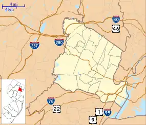 Pleasantdale Location in Essex County  Pleasantdale Location in New Jersey  Pleasantdale Location in the United States | |
| Coordinates: 40°48′37″N 74°15′37″W | |
| Country | |
| State | |
| County | Essex |
| Township | West Orange |
| Area | |
| • Total | 0.79 sq mi (2.05 km2) |
| • Land | 0.79 sq mi (2.05 km2) |
| • Water | 0.00 sq mi (0.00 km2) |
| Elevation | 422 ft (129 m) |
| Population | |
| • Total | 2,329 |
| • Density | 2,948.10/sq mi (1,138.42/km2) |
| Time zone | UTC−05:00 (Eastern (EST)) |
| • Summer (DST) | UTC−04:00 (EDT) |
| ZIP Code | 07052 (West Orange) |
| Area code(s) | 862/973 |
| FIPS code | 34-59385[3] |
| GNIS feature ID | 2806166[4] |
Pleasantdale was first listed as a CDP prior to the 2020 census.[4]
Demographics
As of the 2020 United States census, the population of the area was 2,329.[2]
| Census | Pop. | Note | %± |
|---|---|---|---|
| 2020 | 2,329 | — | |
| U.S. Decennial Census[6] 2020[2] | |||
References
- "ArcGIS REST Services Directory". United States Census Bureau. Retrieved October 11, 2022.
- Census Data Explorer: Pleasantdale CDP, New Jersey, United States Census Bureau. Accessed June 15, 2023.
- Geographic Codes Lookup for New Jersey, Missouri Census Data Center. Accessed June 9, 2023.
- "Pleasantdale Census Designated Place". Geographic Names Information System. United States Geological Survey, United States Department of the Interior.
- State of New Jersey Census Designated Places - BVP20 - Data as of January 1, 2020, United States Census Bureau. Accessed December 1, 2022.
- Census of Population and Housing, United States Census Bureau. Accessed June 1, 2023.
Municipalities and communities of Essex County, New Jersey, United States | ||
|---|---|---|
| Cities | 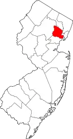 Map of New Jersey highlighting Essex County | |
| Boroughs | ||
| Townships | ||
| CDPs | ||
| Other communities | ||
| Footnotes | ‡This populated place also has portions in an adjacent county or counties | |
This article is issued from Wikipedia. The text is licensed under Creative Commons - Attribution - Sharealike. Additional terms may apply for the media files.