Watsessing, New Jersey
Watsessing is a neighborhood and census-designated place (CDP)[5] located in Bloomfield Township, Essex County, in the U.S. state of New Jersey. It is in the southwest corner of the township, bordered to the northwest by Glen Ridge, to the southwest by East Orange, to the southeast by the Ampere North part of Bloomfield, and to the northeast by the rest of Bloomfield. Watsessing Park is in the center of the community, in the valley of the Second River or Watsessing River, part of the Passaic River watershed.
Watsessing, New Jersey | |
|---|---|
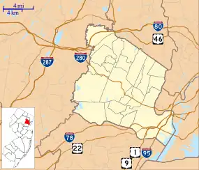 Watsessing Location in Essex County  Watsessing Location in New Jersey  Watsessing Location in the United States | |
| Coordinates: 40°47′16″N 74°12′3″W | |
| Country | |
| State | |
| County | Essex |
| Township | Bloomfield |
| Area | |
| • Total | 0.63 sq mi (1.62 km2) |
| • Land | 0.62 sq mi (1.60 km2) |
| • Water | 0.01 sq mi (0.02 km2) |
| Elevation | 116 ft (35 m) |
| Population | |
| • Total | 8,078 |
| • Density | 13,050.08/sq mi (5,041.06/km2) |
| Time zone | UTC−05:00 (Eastern (EST)) |
| • Summer (DST) | UTC−04:00 (EDT) |
| ZIP Code | 07003 (Bloomfield) |
| Area code(s) | 862/973 |
| FIPS code | 34-77750[3] |
| GNIS feature ID | 2806217[4] |
The Garden State Parkway runs through the center of the community, on the southeast side of Watsessing Park, with access from Exit 148. The parkway leads north 5 miles (8 km) to Clifton and south through East Orange 5 miles (8 km) to Irvington. The NJ Transit Montclair-Boonton Line has two stops in the community: Watsessing Avenue in the southeast and Bloomfield in the northeast.
Watsessing was first listed as a CDP prior to the 2020 census.[4]
References
- "ArcGIS REST Services Directory". United States Census Bureau. Retrieved October 11, 2022.
- "Census Population API". United States Census Bureau. Retrieved October 11, 2022.
- Geographic Codes Lookup for New Jersey, Missouri Census Data Center. Accessed June 9, 2023.
- "Watsessing Census Designated Place". Geographic Names Information System. United States Geological Survey, United States Department of the Interior.
- State of New Jersey Census Designated Places - BVP20 - Data as of January 1, 2020, United States Census Bureau. Accessed December 1, 2022.
- "Census of Population and Housing". Census.gov. Retrieved June 4, 2016.
Municipalities and communities of Essex County, New Jersey, United States | ||
|---|---|---|
| Cities | 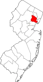 Map of New Jersey highlighting Essex County | |
| Boroughs | ||
| Townships | ||
| CDPs | ||
| Other communities | ||
| Footnotes | ‡This populated place also has portions in an adjacent county or counties | |