Ramechhap District
Ramechhap District (Nepali: रामेछाप जिल्लाⓘ), a part of Bagmati Province, is one of the seventy-seven districts of Nepal, a landlocked country of South Asia. The district, known as Wallo Kirat Ramechhap, has its district headquarters in Manthali and covers an area of 1,546 km2 (597 sq mi) with a population (2011) of 202,646[1] and a density of 137.4 per km2. It has 11 post offices, with the District Post Office (D.P.O.) bearing the postal code 45400.
Ramechhap District
रामेछाप | |
|---|---|
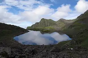 Panch Pokhari at Ramechhap | |
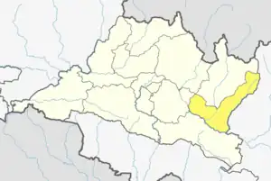 Location of district in province | |
| Country | |
| Province | Bagmati Province |
| Administrative headquarters | Manthali |
| Government | |
| • Type | Coordination committee |
| • Body | DCC, Ramechhap |
| Area | |
| • Total | 1,546 km2 (597 sq mi) |
| Population (2011)[1] | |
| • Total | 202,646 |
| • Density | 130/km2 (340/sq mi) |
| Time zone | UTC+05:45 (NPT) |
| Main Language(s) | Nepali, Magar, Sunuwar, Tamang, Newari and Haayu |
| Official Language(s) | Nepali |
| Website | www |
According to EHRP Nepal,[2] the district is made up of eight local municipalities:
- Manthali Municipality
- Ramechhap Municipality
- Umakunda Rural Municipality
- Khandadevi Rural Municipality
- Gokulganga Rural Municipality
- Doramba Rural Municipality
- Likhu Rural Municipality
- Sunapati Rural Municipality.
Ramechhap District has the highest population of the endangered native group the Kusunda and the lowest population growth rate in Nepal.[3]
Etymology
The district was named after Ramechhap village. The word Ramechhap comes from two Nepali words, Ram (person's name) and chhap (mark). According to folklore, the village of Ramechhap was once occupied by the Tamang people. A Tamang member of the village, named Ram, was granted the role of mukhtiyari (village leader) by royal decree. Consequently, land ownership and other legal activities were authorized in the village by the stamp (chhap) of Ram.
According to another legend, the Tamang people used to rear their domesticated animals such as buffalo, goats, and others in an open meadow here. The word ra means 'goat', mey means 'ox', and chhawa means their small offspring; the meadow of the ra-mey-chhawa ultimately became "Ramechhap".[4]
Geography and climate
| Climate Zone[5] | Elevation Range | % of Area |
|---|---|---|
| Upper Tropical | 300 to 1,000 meters 1,000 to 3,300 ft. |
18.0% |
| Subtropical | 1,000 to 2,000 meters 3,300 to 6,600 ft. |
42.1% |
| Temperate | 2,000 to 3,000 meters 6,400 to 9,800 ft. |
21.0% |
| Subalpine | 3,000 to 4,000 meters 9,800 to 13,100 ft. |
6.7% |
| Alpine | 4,000 to 5,000 meters 13,100 to 16,400 ft. |
3.6% |
| Nival | above 5,000 meters | 7.3% |
Demographics
| Census year | Pop. | ±% p.a. |
|---|---|---|
| 1981 | 161,445 | — |
| 1991 | 188,064 | +1.54% |
| 2001 | 212,408 | +1.22% |
| 2011 | 202,646 | −0.47% |
| 2021 | 170,620 | −1.71% |
| Source: Citypopulation[6] | ||
At the time of the 2011 Nepal census, Ramechhap District had a population of 202,646.
As their first language, 59.4% spoke Nepali, 18.3% Tamang, 6.9% Newari, 5.2% Magar, 5.1% Sherpa, 3.7% Sunuwar, 2.1% Majhi, 1.6% Sherpa, 1.0% Thangmi, 0.5% Yolmo, 0.2% Vayu, 0.2% Maithili, 0.2% Pahari and 0.1% other languages.[7]
Ethnicity/caste: 26.8% Chhetri, 19.2% Tamang, 14.5% Newar, 11.2% Magar, 4.8% Hill Brahmin, 4.2% Sunuwar, 3.2% Kami, 3.1% Sarki, 3.0% Majhi, 2.3% Damai/Dholi, 2.0% Sherpa, 1.6% Gharti/Bhujel, 1.0% Thami, 0.8% Sanyasi/Dasnami, 0.5% Yolmo, 0.4% Hayu, 0.4% Pahari, 0.2% other Dalit, 0.1% Badi, 0.1% Gurung and 0.2% others.[8]
Religion: 71.9% were Hindu, 24.7% Buddhist, 1.6% Christian, 1.4% Prakriti and 0.3% others.[9]
Literacy: 62.0% could read and write, 3.7% could only read and 34.2% could neither read nor write.[10]
Old Village Development Committees (VDCs)
- Bamti Bhandar
- Betali
- Bethan
- Bhirpani
- Bhuji
- Bijulikot
- Chisapani Municipality
- Chanakhu
- Chuchure
- Dadhuwa
- Duragaun
- Deurali
- Dimipokhari
- Doramba
- Duragau
- Gagal Bhadaure
- Gelu
- Goswara
- Gothgau
- Gumdel
- Gunsi Bhadaure
- Gupteshwar
- Hiledevi
- Himganga
- Khandadevi
- Khaniyapani
- Khimti
- Kumbukasthali
- Lakhanpur
- Majuwa
- Makadum
- Manthali Municipality
- Naga Daha
- Namadi
- Pakarbas
- Pharpu
- Phulasi
- Piukhuri
- Priti
- Puranagau
- Rakathum
- Ramechhap Municipality
- Rampur
- Rashnailu
- Saipu
- Sanghutar
- Those
- Tilpung
- Tokarpur
Newly formed local administrative bodies
| Name | Nepali | Population (2011) | Area (km2) | Density (Population/km2) |
|---|---|---|---|---|
| Manthali Municipality | मन्थली नगरपालिका | 45,416 | 100.7 | 451 |
| Ramechhap Municipality | रामेछाप नगरपालिका | 28,612 | 202.45[11] | 141 |
| Umakunda Rural Municipality | उमाकुँण्ड गाउँपालिका | 17,601 | 452 | 39 |
| Khandadevi Rural Municipality | खाँडादेभी गाउँपालिका | 25,761 | 150.7 | 170.9 |
| Doramba Rural Municipality | दोरम्वा गाउँपालिका | 22,738 | 140.88 | 161.4 |
| Gokulganga Rural Municipality | गोकुलगँगा गाउँपालिका | 20,074 | 198.4 | 101.2 |
| Likhutamakoshi Rural Municipality | लिखु तामाकोशी गाउँपालिका | 23,109 | 124.5 | 185.6 |
| Sunapati Rural Municipality | सुनापति गाउँपालिका | 18,141 | 86.9 | 208.7 |
See also
References
- Household and population by districts, Central Bureau of Statistics (CBS) Nepal Archived 2013-07-31 at the Wayback Machine
- "EHRP Nepal: Ramechhap Inspection Dashboard". ehrpinspection.nra.gov.np. Retrieved 2023-10-11.
- District Profile of Ramechhap at Central Bureau of Statistics, Nepal website (in Nepali) Archived 2009-04-30 at the Wayback Machine
- Book: Ramechhap: Introduction, Publication: District Development Committee, Ramechhap, Language: Nepali
- The Map of Potential Vegetation of Nepal - a forestry/agroecological/biodiversity classification system (PDF), Forest & Landscape Development and Environment Series 2-2005 and CFC-TIS Document Series, No. 110, 2005, ISBN 87-7903-210-9, retrieved Nov 22, 2013
- "NEPAL: Administrative Division". www.citypopulation.de.
- NepalMap Language
- NepalMap Caste
- NepalMap Religion
- NepalMap Literacy
- "Brief Introduction | Ramechhap Municipality". ramechhapmun.gov.np. Retrieved 2023-10-11.
External links
- "Districts of Nepal". Statoids.
 Ramechhap travel guide from Wikivoyage
Headquarters: Manthali | ||
| Municipalities | | |
| Rural municipalities | ||
| Former VDCs |
| |