Rangamati
Rangamati (Bengali: রাঙ্গামাটি;) is the administrative headquarter and town of Rangamati Hill District in the Chittagong Hill Tracts of Bangladesh. The town is located at 22°37'60N 92°12'0E and has an altitude of 14 metres (46 ft).[1]
Rangamati
রাঙ্গামাটি | |
|---|---|
 | |
| Nickname: Lake City of Bangladesh | |
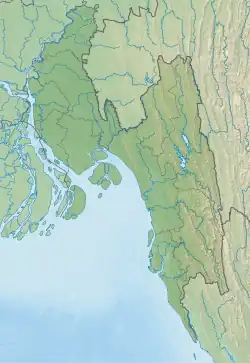 Rangamati Location in Chittagong Division 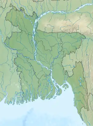 Rangamati Location in Bangladesh | |
| Coordinates: 22°38′N 92°12′E | |
| Country | |
| Division | Chittagong Division |
| District | Rangamati District |
| Government | |
| • Incumbent MP | Dipankar Talukdar |
| • Mayor | Akbar Hossain Chowdhury |
| • Ruling Party | AL |
| Area | |
| • Total | 21 km2 (8 sq mi) |
| Elevation | 14 m (49 ft) |
| Population (2011) | |
| • Total | 66,836 |
| Time zone | UTC+6 (BST) |
| Postal Code | 4500 |
| Area code | 0351 |
| Climate | Am |
From Chittagong a 77 kilometres (48 mi) road leads to Rangamati. The township is located on the western bank of the Kaptai lake. Rangamati is a holiday destination because of its landscape, scenery, lake, indigenous groups (Chakma, Marma, Tripuri, Tanchangya, Pangkhua etc.), flora and fauna, indigenous museum and hanging bridge.
Tourist attractions
Rangamati is surrounded by natural features like as mountains, rivers, lakes, and waterfalls. Rangamati is also home to several ethnic groups. Some of the most popular attractions are:
Climate
| Climate data for Rangamati | |||||||||||||
|---|---|---|---|---|---|---|---|---|---|---|---|---|---|
| Month | Jan | Feb | Mar | Apr | May | Jun | Jul | Aug | Sep | Oct | Nov | Dec | Year |
| Average high °C (°F) | 25.7 (78.3) |
28.5 (83.3) |
32.0 (89.6) |
33.0 (91.4) |
32.7 (90.9) |
31.2 (88.2) |
30.5 (86.9) |
31.0 (87.8) |
31.5 (88.7) |
31.4 (88.5) |
29.1 (84.4) |
26.2 (79.2) |
30.2 (86.4) |
| Average low °C (°F) | 14.0 (57.2) |
15.9 (60.6) |
20.0 (68.0) |
22.9 (73.2) |
24.0 (75.2) |
24.9 (76.8) |
24.8 (76.6) |
24.9 (76.8) |
24.8 (76.6) |
23.9 (75.0) |
20.6 (69.1) |
16.0 (60.8) |
21.4 (70.5) |
| Average precipitation mm (inches) | 5.1 (0.20) |
24.3 (0.96) |
62.1 (2.44) |
147.9 (5.82) |
319.7 (12.59) |
504.8 (19.87) |
572.6 (22.54) |
435.2 (17.13) |
259.6 (10.22) |
152.2 (5.99) |
55.7 (2.19) |
9.5 (0.37) |
2,548.7 (100.34) |
| Average precipitation days | 1 | 2 | 3 | 8 | 13 | 18 | 21 | 20 | 15 | 8 | 4 | 1 | 114 |
| Average relative humidity (%) | 77 | 69 | 67 | 72 | 78 | 84 | 85 | 85 | 85 | 84 | 82 | 81 | 79 |
| Source: Bangladesh Meteorological Department[3][4][5][6][7] | |||||||||||||
Notable people
- Parijat Kusum Chakma
- Aung Shwe Prue Chowdhury
- Binoy Kumar Dewan
- Kamini Mohan Dewan
- Moni Swapan Dewan
- Subimal Dewan, advisor on Chittagong Hill Tracts affairs to President Ziaur Rahman, died in the College Gate area in 2009.[8]
- Santu Larma
- Manabendra Narayan Larma
- Chaithoai Roaza
- Dipankar Talukdar
- Ushatan Talukder
- Shobha Rani Tripura
Gallery
 Rangamati-Kaptai Highway, Rangamati
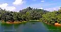 Rangamati, Lake Kaptai
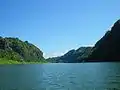
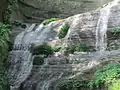 Lower portion of the Shuvolong Fall
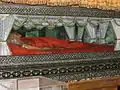 Mummified Body of the Top Mohanto at Rajbana Vihara
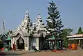 Rajbana Vihara, a renowned Buddhist Temple at Rangamati
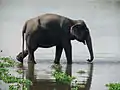 Wild Asian elephant, can be seen in the hilly forests of Rangamati
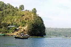 Kaptai Lake Barkal Upazila
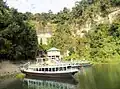 Shuvolong waterfall in dry season
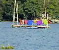 Life in Water
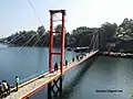 Hanging bridge Rangamati
References
Wikimedia Commons has media related to Rangamati.
- Location of Rangamati - Falling Rain Genomics
- "Top Things to Do in Rangamati". Retrieved 31 August 2021.
- "Monthly Maximum Temperature". Bangladesh Meteorological Department. Retrieved January 31, 2016.
- "Monthly Minimum Temperature". Bangladesh Meteorological Department. Retrieved January 31, 2016.
- "Normal Monthly Rainfall". Bangladesh Meteorological Department. Retrieved January 31, 2016.
- "Normal Monthly Rainy Day". Bangladesh Meteorological Department. Retrieved January 31, 2016.
- "Normal Monthly Humidity". Bangladesh Meteorological Department. Retrieved January 31, 2016.
- "Subimal Dewan passes away". The Daily Star. 3 July 2009.
| Upazila/Thana: | ||
|---|---|---|
This article is issued from Wikipedia. The text is licensed under Creative Commons - Attribution - Sharealike. Additional terms may apply for the media files.