Roëllecourt
Roëllecourt is a commune in the Pas-de-Calais department in the Hauts-de-France region of France.[3]
Roëllecourt | |
|---|---|
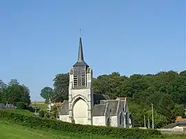 The church of Roëllecourt | |
 Coat of arms | |
Location of Roëllecourt | |
 Roëllecourt  Roëllecourt | |
| Coordinates: 50°22′06″N 2°23′13″E | |
| Country | France |
| Region | Hauts-de-France |
| Department | Pas-de-Calais |
| Arrondissement | Arras |
| Canton | Saint-Pol-sur-Ternoise |
| Intercommunality | CC Ternois |
| Government | |
| • Mayor (2020–2026) | Alain Berthe[1] |
| Area 1 | 9.42 km2 (3.64 sq mi) |
| Population | 528 |
| • Density | 56/km2 (150/sq mi) |
| Time zone | UTC+01:00 (CET) |
| • Summer (DST) | UTC+02:00 (CEST) |
| INSEE/Postal code | 62717 /62130 |
| Elevation | 95–150 m (312–492 ft) (avg. 115 m or 377 ft) |
| 1 French Land Register data, which excludes lakes, ponds, glaciers > 1 km2 (0.386 sq mi or 247 acres) and river estuaries. | |
Geography
Roëllecourt lies 4 km (2.5 mi) east of Saint-Pol-sur-Ternoise, some 29 km (18 mi) west of Arras, at the junction of the D8 and N39 roads.
Population
| Year | Pop. | ±% p.a. |
|---|---|---|
| 1968 | 354 | — |
| 1975 | 366 | +0.48% |
| 1982 | 462 | +3.38% |
| 1990 | 541 | +1.99% |
| 1999 | 595 | +1.06% |
| 2007 | 628 | +0.68% |
| 2012 | 574 | −1.78% |
| 2017 | 538 | −1.29% |
| Source: INSEE[4] | ||
Places of interest
- The sixteenth-century church of St.Omer.
- An eighteenth-century manor house
- A chapel.
- Traces of an old castle.
References
- "Répertoire national des élus: les maires". data.gouv.fr, Plateforme ouverte des données publiques françaises (in French). 9 August 2021.
- "Populations légales 2020". The National Institute of Statistics and Economic Studies. 29 December 2022.
- INSEE commune file
- Population en historique depuis 1968, INSEE
Wikimedia Commons has media related to Roëllecourt.
This article is issued from Wikipedia. The text is licensed under Creative Commons - Attribution - Sharealike. Additional terms may apply for the media files.