Scenic Rim Region
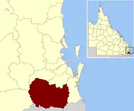
The Scenic Rim Region is a local government area in West Moreton region of South East Queensland, Australia. Established in 2008, it was preceded by several previous local government areas with histories extending back to the early 1900s and beyond. The main town of the region is Beaudesert.
| Scenic Rim Region Queensland | |||||||||||||||
|---|---|---|---|---|---|---|---|---|---|---|---|---|---|---|---|
 Location within South East Queensland | |||||||||||||||
| Population | 42,583 (2018)[1] | ||||||||||||||
| • Density | 10.0361/km2 (25.993/sq mi) | ||||||||||||||
| Established | 2008 | ||||||||||||||
| Area | 4,243 km2 (1,638.2 sq mi)[1] | ||||||||||||||
| Mayor | Greg Christensen[2] | ||||||||||||||
| Council seat | Beaudesert | ||||||||||||||
| Region | West Moreton | ||||||||||||||
| State electorate(s) | Scenic Rim | ||||||||||||||
| Federal division(s) | Wright | ||||||||||||||
 | |||||||||||||||
| Website | Scenic Rim Region | ||||||||||||||
| |||||||||||||||
It has an estimated operating budget of A$33 million.
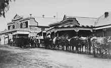
History
Prior to 2008, the new Scenic Rim Region was an entire area of three previous and distinct local government areas:
- the Shire of Boonah;
- the southern part of the Shire of Beaudesert;
- and the Harrisville and Peak Crossing areas from the City of Ipswich.
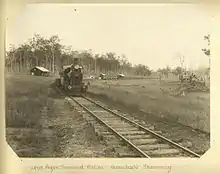

In July 2007, the Local Government Reform Commission released its report and recommended that the areas amalgamate. It identified a rural community of interest as well as ecotourism potential from the Scenic Rim, a group of mountain ranges forming part of the Great Dividing Range, and recommended the transfer of the entire urban growth corridor previously within Beaudesert to Logan City. Along with Lockyer Valley and Somerset, it was expected to provide a rural hinterland for urban South East Queensland. The arrangement was Boonah's second preference (its first was simply absorbing the rural areas of Ipswich) while Beaudesert opposed splitting or amalgamation.[3]
The legislation passed to effect the merger on 10 August 2007. A Local Transition Committee made up of staff and councillors of the dissolving entities was formed to manage the process. On 15 March 2008, the Shires formally ceased to exist, and elections were held on the same day to elect councillors and a mayor to the Regional Council.
Geography


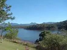
The region is mostly rural, with Beaudesert and Boonah the main towns. It lies within the catchment areas of the Bremer River, the Logan River/Albert River and the Coomera River/Nerang River. The centre of the area is dominated by the Flinders Peak Group and broad sweep of mountainous terrain forming a southern boundary with the local government area on Queensland's southern border with New South Wales. Many high-altitude areas are covered by forests and protected in national parks (including World Heritage listings) at Tamborine Mountain, McPherson Range, Main Range National Park, Mount Barney National Park and landforms including Cunninghams Gap and Fassifern Valley. South East Queensland's highest mountain is Mount Barney, reaching 1,356 metres (4,449 ft) above sea level. Wyaralong Dam is the region's newest reservoir.
In the south east of the local government area is the Lamington National Park. It includes villages such as Canungra, Kooralbyn, Rathdowney, Beechmont and Harrisville. The peak at Mount French, part of Moogerah Peaks National Park is noted for its traditional rock climbing and does not have bolted climbing routes. The peak also boasts a '32' rated climb (one of the hardest in the world) which attracts international rock climbing visitors to the area. The area of Boonah is fairly flat with large areas of very productive soils for the growing of vegetables and other crops. Beechmont and O'Reillys are mountainous areas overlooking the Gold Coast hinterland. These areas attract visitors for camping, bushwalking and bird watching.
Divisions and councillors
The council is split into 6 divisions, each returning one councillor, plus a mayor.
Current composition of council
| Constituency | Name |
|---|---|
| Mayor | Greg Christensen |
| Division 1 | Amanda Hay |
| Division 2 | Jeff McConnell (deputy mayor) |
| Division 3 | Virginia West |
| Division 4 | Michael Enright |
| Division 5 | Marshall Chalk |
| Division 6 | Duncan McInnes |
Mayors
John Brent was the region's first mayor. He was first elected as a councillor in the Shire of Boonah in 1976 and was chairman of the Shire of Boonah beginning on 12 April 1994, becoming mayor of the Scenic Rim Region following the amalgamation.[4]
| Member | Party | Term | Notes | |
|---|---|---|---|---|
| John Brent | Independent | 2008–2016 | [4][5] | |
| Greg Christensen | Independent | 2016–present | Although a member of the Liberal–National Party, Christensen contested the 2016 and 2020 elections as an independent, stating in 2016 "I don't believe party politics should play a part in a local government of our size".[6][2][7] | |
Deputy mayors
In 2016, the council resolved to review the position of deputy mayor annually, instead of having it be the longer-term position it was from 2008 to 2016.[8]
List of councillors
Division 1
| Term | Name | Notes |
|---|---|---|
| 2008–2012 | Derek Swanborough | Did not recontest in 2012; instead, unsuccessfully ran for mayor |
| 2012–2020 | Nigel Waistell | Deputy mayor 2016–2017. Retired |
| 2020–2023 | Derek Swanborough | Resigned to retire from politics |
| 2023–present | Amanda Hay | Incumbent |
Division 2
| Term | Name | Notes |
|---|---|---|
| 2008–2012 | Richard Adams | Lost seat |
| 2012–2020 | Nadia O'Carroll | Deputy mayor 2017–2018. Did not recontest in 2020; instead, unsuccessfully ran for division 1 |
| 2020–present | Jeff McConnell | Incumbent. Deputy mayor 2022–present |
Division 3
| Term | Name | Notes |
|---|---|---|
| 2008–present | Virginia West | Incumbent. Deputy mayor 2012–2016 |
Division 4
| Term | Name | Notes |
|---|---|---|
| 2008–2012 | Dave Cockburn | Deputy mayor 2008–2012. Retired |
| 2012–2016 | Jennifer Sanders | Lost seat |
| 2016–present | Michael Enright | Incumbent. Deputy mayor 2021–2022 |
Division 5
| Term | Name | Notes |
|---|---|---|
| 2008–2012 | Kathy Bensted | Lost seat |
| 2012–2020 | Rick Stanfield | Deputy mayor 2018–2019. Retired |
| 2020–present | Marshall Chalk | Incumbent |
Division 6
| Term | Name | Notes |
|---|---|---|
| 2008–2012 | Heather Wehl | Retired |
| 2012–present | Duncan McInnes | Incumbent. Deputy mayor 2019–2021 |
Source: Electoral Commission of Queensland[14][15][16][17][18]
Towns and localities
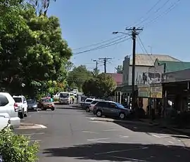
The Scenic Rim Region includes the following settlements:
|
Beaudesert area: |
Boonah area:
|
Other areas:
1 - split with the City of Ipswich 2 - split with Logan City
Population

The populations given relate to the component entities prior to 2008.
| Year | Population |
|---|---|
| 1986 | 22,992 |
| 1991 | 28,512 |
| 1996 | 32,997 |
| 2001 | 35,342 |
| 2006 | 34,659 |
Heritage register
In 2014, the Scenic Rim Regional Council established its local heritage register as required by the Queensland Heritage Act 1992. In February 2015, it listed 54 places based on criteria in the Australia ICOMOS Burra Charter 1999.[19]
Libraries
The Scenic Rim Regional Council operate libraries in Beaudesert, Boonah, Canungra and Tamborine Mountain. The council commenced a mobile library service in 2008,[20] which serves Beechmont, Harrisville, Hillview, Kalbar, Kooralbyn, Peak Crossing, Rathdowney and Tamborine.[21]
References
- "3218.0 – Regional Population Growth, Australia, 2017-18: Population Estimates by Local Government Area (ASGS 2018), 2017 to 2018". Australian Bureau of Statistics. Australian Bureau of Statistics. 27 March 2019. Archived from the original on 27 March 2019. Retrieved 25 October 2019. Estimated resident population, 30 June 2018.
- "2016 Scenic Rim Regional Council - Mayoral Election - Election Summary". results.ecq.qld.gov.au. 20 April 2016. Archived from the original on 14 February 2017. Retrieved 4 December 2017.
- Queensland Local Government Reform Commission (July 2007). Report of the Local Government Reform Commission (PDF). Vol. 2. pp. 32–36. ISBN 978-1-921057-11-3. Archived from the original (PDF) on 17 March 2011. Retrieved 2 March 2010.
- "One of the most enduring leaders in Queensland local government, Scenic Rim Mayor John Brent has a blunt and simple response to questions about the role of a council and its mayor... - Local Government Association of Queensland". lgaq.asn.au. Archived from the original on 4 December 2017. Retrieved 4 December 2017.
- "2012 Scenic Rim Regional Council - Mayoral Election - Election Summary". results.ecq.qld.gov.au. Archived from the original on 8 May 2016. Retrieved 4 December 2017.
- Anna_Hartley (28 March 2016). "Greg Christensen confident he is the new mayor of Scenic Rim". Queensland Times. Archived from the original on 24 June 2020. Retrieved 24 June 2020.
- "2020 Local Government Elections: Saturday, 28 March 2020". Electoral Commission of Queensland. 2020. Retrieved 16 June 2020.
- "COUNCIL ELECTS NEW DEPUTY MAYOR". Scenic Rim Regional Council. 28 May 2019. Retrieved 8 May 2023.
- 2008/09 ANNUAL REPORT (Report). Scenic Rim Regional Council. 2009. Retrieved 8 May 2023.
- 2010/2011 annual report (Report). Scenic Rim Regional Council. 2011. Retrieved 8 May 2023.
- "Division 3 - Cr Virginia West". Scenic Rim Regional Council. Retrieved 8 May 2023.
- "Council appoints new Deputy Mayor and Councillor representations". Scenic Rim Regional Council. 25 May 2021. Retrieved 8 May 2023.
- "Scenic Rim Regional Council Deputy Mayor elected". Scenic Rim Regional Council. 26 May 2022. Retrieved 8 May 2023.
- "2008 SCENIC RIM REGIONAL COUNCIL - COUNCILLOR ELECTION - ELECTION SUMMARY". Electoral Commission of Queensland. Archived from the original on 5 October 2009. Retrieved 8 May 2023.
- "2012 Scenic Rim Regional Council - Councillor Election - Election Summary". Electoral Commission of Queensland. Retrieved 8 May 2023.
- "2016 Scenic Rim Regional Council - Councillor Election - Election Summary". Electoral Commission of Queensland. Retrieved 8 May 2023.
- "2020 Local Government Elections". Electoral Commission of Queensland. Retrieved 8 May 2023.
- "2023 Scenic Rim Regional Council Councillor By-election - Division 1". Electoral Commission of Queensland. Retrieved 8 May 2023.
- "Local Heritage Register". Scenic Rim Regional Council. Archived from the original on 10 February 2015. Retrieved 9 February 2015.
- "Public Libraries Statistical Bulletin 2016-17" (PDF). Public Libraries Connect. State Library of Queensland. November 2017. p. 15. Archived (PDF) from the original on 30 January 2018. Retrieved 30 January 2018.
- "Locations and Membership". Scenic Rim Regional Council. Archived from the original on 30 January 2018. Retrieved 31 January 2018.
Further reading
- Teese, Nerelie (2001), Hurricane lamps & handmilking : a history of dairy farming along the Logan & Albert River Valleys, Nerelie Teese, ISBN 978-0-9579326-0-9
External links
- "Local Heritage Register". Scenic Rim Regional Council. Archived from the original on 10 February 2015. Retrieved 9 February 2015.