Sinjai Regency
Sinjai Regency is a regency of South Sulawesi Province of Indonesia. The regency, whichis separated from the Bone Regency to its north by the River Tangka, covers an area of 819.96 km2. It had a population of 228,936 at the 2010 Census[2] and 259,478 at the 2020 Census;[3] the official estimate as at mid 2022 was 263,827 (comprising 130,565 males and 133,262 females).[1] It includes the Nine Islands (Kepulauan Sembilan) in the Gulf of Bone off the east coast of the southern peninsula of Sulawesi; this archipelago forms a district within the regency. The regency's principal town lies at Sinjai, a port situated on the east coast of that peninsula.
Sinjai Regency
Kabupaten Sinjai | |
|---|---|
 Coat of arms | |
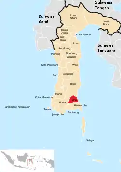 Location within South Sulawesi | |
| Coordinates: 5°7′S 120°09′E | |
| Country | Indonesia |
| Province | South Sulawesi |
| Capital | Sinjai |
| Government | |
| • Regent | Sabirin Yahya |
| • Vice Regent | A Fajar Yanwar |
| Area | |
| • Total | 819.96 km2 (316.59 sq mi) |
| Population (mid 2022 estimate)[1] | |
| • Total | 263,827 |
| • Density | 320/km2 (830/sq mi) |
| Time zone | UTC+8 (Indonesia Central Time) |
| Area code | (+62) 482 |
| Website | www |

Sembilan Islands (Pulau Sembilan)
The small group of mountainous, forest-covered islands known as the Sembilan Islands lies of the east coast of South Sulawesi province, and are northeast of the port town of Sinjai. Notwithstanding the name, there are actually ten named islands forming the group, as Pulau Kanalosatu and Pulau Kanalodua are structurally linked and normally classed as one island (Kanalo). There are four administrative desa within the district.
In the south, the desa of Pulau Buhung Pitue (with an area of 2.15 km2) covers the island of Pulau Burungloe. To the northeast, the desa of Pulau Harapan (1.75 km2) covers the islands of Pulau Liangliang and Pulau Kambuno. Further north is the desa of Pulau Padaelo (1.80 km2), which covers the island of Pulau Kodingare. Finally, north and west of Pulau Kodingare, the desa of Pulau Persetuan (1.85 km2) covers the islands of Pulau Batanglampe, Pulau Kanalosatu, Pulau Kanalodua, Pulau Katindoang, Pulau Lapoipoi and Pulau Larearea.
Administrative Districts
The regency is divided into nine districts (kecamatan), tabulated below with their areas and their populations at the 2010 Census[2] and the 2020 Census,[3] together with the official estimates as at mid 2022.[1] The table also includes the locations of the district administrative centres, the number of administrative villages in each district (totalling 67 rural desa and 13 urban kelurahan), and its post code(s).
| Name of District (kecamatan) | (English name) | Area in kn2 | Pop'n Census 2010 | Pop'n Census 2020 | Pop'n Estimate mid 2022 | Admin centre | No. of villages | Post code |
|---|---|---|---|---|---|---|---|---|
| Sinjai Barat | (West Sinjai) | 135.53 | 22,985 | 25,873 | 26,285 | Tassililu | 9 | 92653 |
| Sinjai Borong | 66.97 | 15,901 | 17,718 | 17,964 | Pasir Putih | 8 | 92662 | |
| Sinjai Selatan | (South Sinjai) | 131.99 | 37,055 | 40,473 | 40,878 | Bikeru | 11 | 92661 |
| Tellu Limpoe | 147.30 | 31,448 | 37,724 | 38,588 | Mannanti | 11 | 92681 | |
| Sinjai Timur | (East Sinjai) | 71.88 | 28,971 | 33,765 | 34,470 | Samataring | 13 | 92671 |
| Sinjai Tengah | (Central Sinjai) | 129.70 | 25,867 | 28,337 | 28,436 | Samaenre | 11 | 92652 |
| Sinjai Utara | (North Sinjai) | 29.57 | 43,467 | 50,498 | 51,616 | Balingnipa | 6 | 92611 - 92616 |
| Bulupoddo | 99.47 | 15,681 | 17,522 | 17,775 | Lamatti Riattang | 7 | 92654 | |
| Pulau Sembilan | (Nine Islands) | 7.55 | 7,405 | 7,568 | 7,635 | Pulau Harapan | 4 | 92616 |
| Totals | 819.96 | 228,936 | 259,478 | 263,827 | Sinjai | 80 |
References
- Badan Pusat Statistik, Jakarta, 2023, Kabupaten Sinjai Dalam Angka 2023 (Katalog-BPS 1102001.7307)
- Biro Pusat Statistik, Jakarta, 2011.
- Badan Pusat Statistik, Jakarta, 2021.
Regencies and cities of South Sulawesi | ||
|---|---|---|
Capital: Makassar | ||
| Regencies |  | |
| Cities | ||