Situbondo Regency
Situbondo Regency is a regency (kabupaten) of East Java province, Indonesia. It covers an area of 1,638.50 km2, and had a population of 647,619 at the 2010 Census[2] and 685,967 at the 2020 Census;[3] the official estimate as at mid 2022 was 673,102 (comprising 329,350 males and 343,752 females).[1] It is located towards the eastern end of Java, before Banyuwangi. The administrative centre is Situbondo, a small town within the regency. One of the famous tourist sites is Baluran National Park.
Situbondo Regency
Kabupaten Situbondo | |
|---|---|
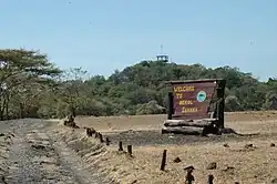 Savannah Bekol | |
 Coat of arms | |
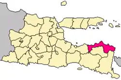 Location within East Java | |
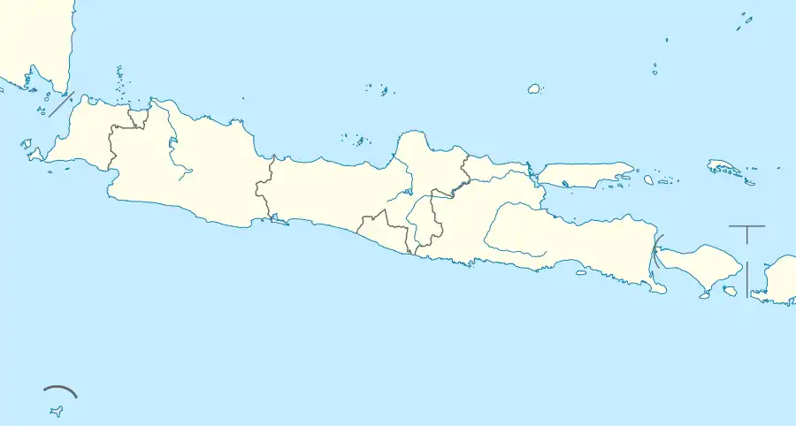
| Coordinates: 7°42′S 114°00′E | |
| Country | |
| Province | East Java |
| Capital | Situbondo |
| Anniversary | 15 August 1818 |
| Government | |
| • Regent | Karna Suswandi |
| • Regent | Drs. H. Karna Suswandi, M.M. |
| • Vice Regent | Hj. Khoirani, S.Pd., M.M. |
| Area | |
| • Total | 1,638.50 km2 (632.63 sq mi) |
| Population (mid 2022 estimate)[1] | |
| • Total | 673,102 |
| • Density | 410/km2 (1,100/sq mi) |
| Time zone | UTC+7 (IWST) |
| Area code | (+62) 338 |
| Website | situbondokab |

Administrative districts
The Regency is divided into seventeen districts (kecamatan), tabulated below with their areas and their population totals from the 2010 Census[2] and the 2020 Census,[3] together with the official estimates as at mid 2022.[1] The table also includes the locations of the district headquarters and the number of administrative villages in each district (totaling 132 rural desa and 4 urban kelurahan).
| Name of District (kecamatan) | Area in km2 | Pop'n Census 2010 | Pop'n Census 2020 | Pop'n Estimate mid 2022 | Admin centre | No. of villages |
|---|---|---|---|---|---|---|
| Sumbermalang | 129.47 | 26,319 | 28,466 | 28,056 | Tlogosari | 9 |
| Jatibanteng | 66.08 | 21,847 | 23,083 | 22,538 | Jatibanteng | 8 |
| Banyuglugur | 72.66 | 22,443 | 24,583 | 23,661 | Banyuglugur | 7 |
| Besuki | 26.41 | 61,211 | 65,110 | 64,586 | Besuki | 10 |
| Suboh | 30.84 | 26,186 | 28,178 | 28,087 | Buduan | 8 |
| Mlandingan | 39.61 | 22,371 | 23,809 | 23,934 | Mlandingan Kulon | 7 |
| Bungatan | 66.07 | 24,417 | 25,982 | 25,417 | Bungatan | 7 |
| Kendit | 114.14 | 28,172 | 29,310 | 29,426 | Kendit | 7 |
| Panarukan | 54.38 | 53,034 | 58,315 | 57,946 | Wringin Anom | 8 |
| Situbondo | 27.81 | 46,854 | 48,656 | 48,297 | Patokan | 6 (a) |
| Mangaran | 35.70 | 31,937 | 34,181 | 34,315 | Mangaran | 6 |
| Panji | 46.99 | 68,286 | 66,926 | 66,581 | Mimbaan | 12 (a) |
| Kapongan | 44.55 | 36,990 | 38,939 | 38,994 | Kesambi Rampak | 10 |
| Arjasa | 216.38 | 39,708 | 43,637 | 42,423 | Arjasa | 8 |
| Jangkar | 67.00 | 36,321 | 41,012 | 39,018 | Jangkar | 8 |
| Asembagus | 118.74 | 47,256 | 49,661 | 49,100 | Asembagus | 10 |
| Banyuputih | 481.67 | 54,267 | 56,119 | 50,723 | Sumberanyar | 5 |
| Totals | 1,638.50 | 647,619 | 685,967 | 673,102 | Situbondo | 136 |
Note: (a) including 2 kelurahan.
Climate
Situbondo has a tropical savanna climate (Aw) with heavy rainfall from December to March and moderate to little rainfall from April to November.
| Climate data for Situbondo | |||||||||||||
|---|---|---|---|---|---|---|---|---|---|---|---|---|---|
| Month | Jan | Feb | Mar | Apr | May | Jun | Jul | Aug | Sep | Oct | Nov | Dec | Year |
| Average high °C (°F) | 31.1 (88.0) |
31.1 (88.0) |
31.3 (88.3) |
31.7 (89.1) |
31.7 (89.1) |
31.6 (88.9) |
31.5 (88.7) |
31.9 (89.4) |
33.0 (91.4) |
33.6 (92.5) |
33.2 (91.8) |
31.9 (89.4) |
32.0 (89.6) |
| Daily mean °C (°F) | 26.0 (78.8) |
26.0 (78.8) |
26.1 (79.0) |
26.4 (79.5) |
26.3 (79.3) |
25.9 (78.6) |
25.4 (77.7) |
25.8 (78.4) |
26.6 (79.9) |
27.2 (81.0) |
27.2 (81.0) |
26.5 (79.7) |
26.3 (79.3) |
| Average low °C (°F) | 20.9 (69.6) |
21.0 (69.8) |
21.0 (69.8) |
21.2 (70.2) |
20.9 (69.6) |
20.2 (68.4) |
19.3 (66.7) |
19.7 (67.5) |
20.2 (68.4) |
20.8 (69.4) |
21.2 (70.2) |
21.1 (70.0) |
20.6 (69.1) |
| Average rainfall mm (inches) | 281 (11.1) |
243 (9.6) |
193 (7.6) |
77 (3.0) |
64 (2.5) |
35 (1.4) |
20 (0.8) |
6 (0.2) |
4 (0.2) |
18 (0.7) |
67 (2.6) |
187 (7.4) |
1,195 (47.1) |
| Source: Climate-Data.org[4] | |||||||||||||
Gallery

 Two groups of men under a large banyan tree in Situbondo
 River and washed away bridge in the area of Situbondo
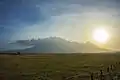
References
- Badan Pusat Statistik, Jakarta, 2023, Kabupaten Situbondo Dalam Angka 2023 (Katalog-BPS 1102001.3512)
- Biro Pusat Statistik, Jakarta, 2011.
- Badan Pusat Statistik, Jakarta, 2021.
- "Climate: Situbondo". Climate-Data.org. Retrieved 10 November 2020.
