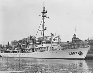
Snellius-class hydrographic survey vessel (1950)
The Snellius class was a ship class of two hydrographic survey vessels that were built in the Netherlands for the Royal Netherlands Navy.[2][3] They were specially designed to be able to conduct surveys under tropical conditions.[4]
 Snellius | |
| Class overview | |
|---|---|
| Name | Snellius class |
| Builders |
|
| Operators | |
| Succeeded by | |
| Built | 1949–1952 |
| In commission | 1952–1977 |
| Planned | 2 |
| Completed | 2 |
| General characteristics [1] | |
| Type | Hydrographic survey vessel |
| Displacement | 1,538 t (1,514 long tons) |
| Length | 71.4 m (234 ft 3 in) |
| Beam | 10.8 m (35 ft 5 in) |
| Draft | 4 metres (13 ft 1 in) |
| Propulsion |
|
| Speed | 15 knots (28 km/h; 17 mph) |
| Crew | 108 |
| Armament |
|
Design and construction
The two hydrographic survey vessels of the Snellius class were built at different shipyards in the Netherlands. Snellius was built at the shipyard of P. Smit Jr. in Rotterdam, while Luymes was built at the shipyard of Gusto in Schiedam.[5]
Both ships of the Snellius class were equipped with a single 40 mm gun, two 20 mm guns, two depth charge throwers and a single mousetrap.[4] Furthermore, they had two 6-cylinder four-stroke Stork diesel engines that could deliver up to 1,000 horsepower (750 kW) each, for a total of 2,000 hp (1,500 kW).[2] This allowed them to reach a maximum speed of 15 knots (28 km/h; 17 mph).[5]
For surveying the ships were equipped with several systems.[6] They had echo sounders that could reach a depth of nine kilometres (5.6 mi) and a sonar that could record unevenness on the sea floor as long as the sea floor was within a distance of one kilometre (0.62 mi) below the ship.[7] Furthermore, a Decca positioning system was installed.[8]
Service history
Between 1952 and 1962 the vessels of the Snellius class mostly performed surveys in Dutch New Guinea.[3][8] However, during the heightened tensions in 1962 they were also used as patrol ships in Dutch New Guinea.[9] At the end of 1962 Snellius and Luymes left Dutch New Guinea.[10]
Between 1965 and 1969 the survey vessels were active in Suriname and mapped the whole Surinamese continental plate and all the estuaries.[11]
Between 1970 and 1973 Snellius and Luymes alternately participated in an international oceanographic survey that was conducted in the Caribbean Sea, the Gulf of Mexico and the waters between the northern part of South America and the estuary of the Amazon River.[12][13]
In the 1970s both ships were deemed obsolete and in need of replacement.[14][11] As a result Luymes was decommissioned in 1973, while Snellius was decommissioned in 1977 after having served as lodging ship between 1973 and 1976.[4]
Ships in class
| Ship | Pennant No. | Builder | Laid down | Launched | Commissioned | Decommissioned | Fate |
|---|---|---|---|---|---|---|---|
| Snellius | A907 | P. Smit Jr., Rotterdam | 3 January 1949 | 9 December 1950 | 4 February 1952 | 21 January 1977 | Sold to Wilton-Fijenoord on 31 May 1977. |
| Luymes | A902 | Gusto Shipyard, Schiedam | 4 April 1949 | 21 April 1951 | 4 May 1952 | 2 March 1973 | Sold to Pounds Marine Shipping Co. on 29 May 1973. Later rebuild as yacht. |
Notes
Citations
- van Amstel (1991), pp. 89-90.
- "Marine opnemingsvaartuig „Snellius"". Trouw (in Dutch). 12 March 1951.
- Raven (1988), p. 124.
- van Amstel (1991), p. 90.
- "Opnemingsvaartuig Snellius gisteren in dienst gesteld". Algemeen Dagblad (in Dutch). 5 February 1952.
- "Ondiepe Noordzee schept problemen: Mammoet-schepen vragen speciale vaarroutes". Friese Koerier (in Dutch). 18 June 1963.
- "Hydrografie, boeiend en eindeloos: Marine speurt langs bodem van Noordzee". Nieuwe Haarlemsche Courant (in Dutch). 7 September 1963.
- Woudstra (1982), p. 161.
- Schoonoord (2012), p. 131.
- "Aftocht uit West-Irian: Marine 15 November geheel vertrokken". De Waarheid (in Dutch). 12 September 1962.
- Woudstra (1982), p. 162.
- "Curacao operationeel centrum: Internationaal oceanografisch onderzoek in Caribisch gebied". Amigoe di Curaçao (in Dutch). 3 November 1969.
- "Internationaal project: Onderzoek oceaan in Caraïbisch gebied". Algemeen Handelsblad (in Dutch). 4 November 1969.
- J. A. Redeker (20 July 1974). "Water, in oppervlakte 70 procent van onze aardbol, is braakliggend terrein waar te weinig onderzoekers hand naar uitsteken: De zee blijft links liggen". Algemeen Dagblad (in Dutch).
References
- Schoonoord, D.C.L. (2012). Pugno pro patria: de Koninklijke Marine tijdens de Koude Oorlog (in Dutch). Franeker: Van Wijnen. ISBN 978-90-5194-455-6.
- van Amstel, W.H.E. (1991). De schepen van de Koninklijke Marine vanaf 1945 (in Dutch). Alkmaar: De Alk. ISBN 90-6013-997-6.
- Raven, G.J.A., ed. (1988). De kroon op het anker: 175 jaar Koninklijke Marine (in Dutch). Amsterdam: De Bataafsche Leeuw. ISBN 90-6707-200-1.
- Woudstra, F.G.A. (1982). Onze Koninklijke Marine (in Dutch). Alkmaar: De Alk. ISBN 90-6013-915-1.