Sonid Left Banner
Sonid Left Banner (Mongolian: ᠰᠥᠨᠡᠳ ᠵᠡᠭᠦᠨ ᠬᠣᠰᠢᠭᠤ; Chinese: 苏尼特左旗) is a banner of north-central Inner Mongolia, China, bordering the Mongolia's provinces of Dornogovi to the west and Sükhbaatar to the north. It is under the administration of Xilingol League. Sunud Mongols live here.

Sonid Left Banner
苏尼特左旗 • ᠰᠥᠨᠡᠳ ᠵᠡᠭᠦᠨ ᠬᠣᠰᠢᠭᠤ | |
|---|---|
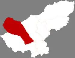 Sonid Left Banner in Xilin Gol | |
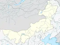
.svg.png.webp) Xilin Gol in Inner Mongolia | |
 Sonid Left Location of the seat in Inner Mongolia  Sonid Left Sonid Left (China) | |
| Coordinates: 43°51′36″N 113°40′01″E | |
| Country | China |
| Autonomous region | Inner Mongolia |
| League | Xilin Gol |
| Banner seat | Mandalt |
| Area | |
| • Total | 34,250 km2 (13,220 sq mi) |
| Population (2020)[1] | |
| • Total | 33,643 |
| • Density | 0.98/km2 (2.5/sq mi) |
| Time zone | UTC+8 (China Standard) |
| Website | www |
| Sonid Left Banner | |||||||
|---|---|---|---|---|---|---|---|
| Chinese name | |||||||
| Simplified Chinese | 苏尼特左旗 | ||||||
| Traditional Chinese | 蘇尼特左旗 | ||||||
| |||||||
| Mongolian name | |||||||
| Mongolian Cyrillic | Сөнөд зүүн хошуу | ||||||
| Mongolian script | ᠰᠥᠨᠡᠳ ᠵᠡᠭᠦᠨ ᠬᠣᠰᠢᠭᠤ | ||||||
| |||||||
Demographics
Administrative divisions
Sonid Left Banner is divided into 3 towns and 4 sums.
| Name | Simplified Chinese | Hanyu Pinyin | Mongolian (Hudum Script) | Mongolian (Cyrillic) | Administrative division code |
|---|---|---|---|---|---|
| Towns | |||||
| Mandalt Town | 满都拉图镇 | Mǎndūlātú Zhèn | ᠮᠠᠨᠳᠠᠯᠲᠤ ᠪᠠᠯᠭᠠᠰᠤ | Мандалт балгас | 152523100 |
| Qagan Obo Town | 查干敖包镇 | Chágàn'áobāo Zhèn | ᠴᠠᠭᠠᠨᠣ᠋ᠪᠣᠭᠠ ᠪᠠᠯᠭᠠᠰᠤ | Цагаан-Овоо балгас | 152523101 |
| Bayan Nur Town | 巴彦淖尔镇 | Bāyànnào'ěr Zhèn | ᠪᠠᠶᠠᠨᠨᠠᠭᠤᠷ ᠪᠠᠯᠭᠠᠰᠤ | Баяннуур балгас | 152523102 |
| Sums | |||||
| Bayan Ul Sum | 巴彦乌拉苏木 | Bāyànwūlā Sūmù | ᠪᠠᠶᠠᠨ᠌ᠠ᠋ᠭᠤᠯᠠ ᠰᠤᠮᠤ | Баян-Уул сум | 152523200 |
| Saihan Gobi Sum | 赛罕高毕苏木 | Sàihǎngāobì Sūmù | ᠰᠠᠢᠬᠠᠨᠭᠣᠪᠢ ᠰᠤᠮᠤ | Сайханговь сум | 152523201 |
| Honggor Sum | 洪格尔苏木 | Hónggé'ěr Sūmù | ᠬᠣᠩᠭᠣᠷ ᠰᠤᠮᠤ | Хонгор сум | 152523202 |
| Dalai Sum | 达来苏木 | Dálái Sūmù | ᠳᠠᠯᠠᠢ ᠰᠤᠮᠤ | Далай сум | 152523203 |
Others:
- Sonid Left Banner Manglai Circular Economy Industrial Park (苏尼特左旗芒来循环经济产业园区)
- Engger Gol Irrigation Area (恩格尔河灌区)
Climate
Sonid Left Banner features a cold semi-arid climate (Köppen BSk), marked by long, cold and very dry winters, hot, somewhat humid summers, and strong winds, especially in spring. The monthly 24-hour mean temperature in January, the coldest month, is −18.7 °C (−1.7 °F), and in July, the warmest month, 22.0 °C (71.6 °F), with the annual mean at 3.07 °C (37.5 °F). The annual precipitation is 185 millimetres (7.28 in), with more than half of it falling in July and August alone.
| Climate data for Sonid Left Banner (1991–2020 normals, extremes 1971–2010) | |||||||||||||
|---|---|---|---|---|---|---|---|---|---|---|---|---|---|
| Month | Jan | Feb | Mar | Apr | May | Jun | Jul | Aug | Sep | Oct | Nov | Dec | Year |
| Record high °C (°F) | 6.9 (44.4) |
10.8 (51.4) |
18.4 (65.1) |
31.5 (88.7) |
33.8 (92.8) |
38.5 (101.3) |
41.5 (106.7) |
38.2 (100.8) |
35.6 (96.1) |
27.2 (81.0) |
18.9 (66.0) |
6.8 (44.2) |
41.5 (106.7) |
| Average high °C (°F) | −12.4 (9.7) |
−6.1 (21.0) |
3.9 (39.0) |
14.1 (57.4) |
21.7 (71.1) |
26.9 (80.4) |
29.6 (85.3) |
27.7 (81.9) |
21.5 (70.7) |
11.9 (53.4) |
0.0 (32.0) |
−10.0 (14.0) |
10.7 (51.3) |
| Daily mean °C (°F) | −18.7 (−1.7) |
−13.4 (7.9) |
−3.4 (25.9) |
6.7 (44.1) |
14.6 (58.3) |
20.6 (69.1) |
23.5 (74.3) |
21.5 (70.7) |
14.8 (58.6) |
4.9 (40.8) |
−6.4 (20.5) |
−15.9 (3.4) |
4.1 (39.3) |
| Average low °C (°F) | −23.7 (−10.7) |
−19.2 (−2.6) |
−9.7 (14.5) |
−0.2 (31.6) |
7.5 (45.5) |
14.1 (57.4) |
17.5 (63.5) |
15.4 (59.7) |
8.6 (47.5) |
−0.7 (30.7) |
−11.4 (11.5) |
−20.8 (−5.4) |
−1.9 (28.6) |
| Record low °C (°F) | −35.5 (−31.9) |
−33.5 (−28.3) |
−26.3 (−15.3) |
−19.0 (−2.2) |
−9.4 (15.1) |
1.0 (33.8) |
7.3 (45.1) |
1.0 (33.8) |
−5.3 (22.5) |
−18.2 (−0.8) |
−29.3 (−20.7) |
−34.3 (−29.7) |
−35.5 (−31.9) |
| Average precipitation mm (inches) | 1.4 (0.06) |
1.7 (0.07) |
3.6 (0.14) |
7.8 (0.31) |
17.5 (0.69) |
32.0 (1.26) |
43.7 (1.72) |
38.2 (1.50) |
18.6 (0.73) |
9.6 (0.38) |
3.9 (0.15) |
2.2 (0.09) |
180.2 (7.1) |
| Average precipitation days (≥ 0.1 mm) | 3.2 | 2.5 | 3.7 | 3.0 | 5.1 | 8.1 | 9.4 | 7.5 | 5.9 | 3.6 | 3.9 | 4.1 | 60 |
| Average snowy days | 6.0 | 4.8 | 4.7 | 2.5 | 0.7 | 0 | 0 | 0 | 0.2 | 2.1 | 5.8 | 7.0 | 33.8 |
| Average relative humidity (%) | 69 | 62 | 45 | 32 | 34 | 42 | 48 | 49 | 45 | 47 | 58 | 68 | 50 |
| Mean monthly sunshine hours | 217.7 | 229.0 | 277.4 | 284.0 | 300.1 | 294.3 | 299.3 | 296.8 | 272.3 | 248.8 | 209.0 | 198.7 | 3,127.4 |
| Percent possible sunshine | 75 | 77 | 74 | 70 | 65 | 64 | 65 | 69 | 74 | 74 | 73 | 72 | 71 |
| Source 1: China Meteorological Administration[3][4] | |||||||||||||
| Source 2: Weather China[5] | |||||||||||||
See also
References
- Inner Mongolia: Prefectures, Cities, Districts and Counties
- 内蒙古自治区第七次全国人口普查领导小组办公室、内蒙古自治区统计局. "内蒙古人口普查年鉴-2020".
- 中国气象数据网 – WeatherBk Data (in Simplified Chinese). China Meteorological Administration. Retrieved 10 October 2023.
- 中国气象数据网 (in Simplified Chinese). China Meteorological Administration. Retrieved 10 October 2023.
- 苏尼特左旗 - 气象数据 -中国天气网 (in Chinese). Weather China. Retrieved 25 November 2022.
- www.xzqh.org (in Chinese)