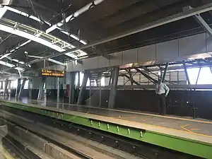
Srirampura metro station
Srirampura is an elevated metro station on the North-South corridor of the Green Line of Namma Metro serving the Srirampura area of Bengaluru, India. It was opened to the public on 1 March 2014.[1][2]
Station layout
Srirampura track layout | ||||||||||||||||||||||||||||||||||||||||||
|---|---|---|---|---|---|---|---|---|---|---|---|---|---|---|---|---|---|---|---|---|---|---|---|---|---|---|---|---|---|---|---|---|---|---|---|---|---|---|---|---|---|---|
| ||||||||||||||||||||||||||||||||||||||||||
Station with two tracks and two side platforms | ||||||||||||||||||||||||||||||||||||||||||
| G | Street level | Exit/Entrance |
| L1 | Mezzanine | Fare control, station agent, Metro Card vending machines, crossover |
| L2 | Side platform | Doors will open on the left | |
| Platform 2 Southbound |
Towards → Silk Institute next station is Mantri Square Sampige Road | |
| Platform 1 Northbound |
Towards ← Nagasandra next station is Mahakavi Kuvempu Road | |
| Side platform | Doors will open on the left | ||
| L2 | ||
Entry/Exits
There are 3 Entry/Exit points – A, B and C. Commuters can use either of the points for their travel.
See also
References
- "Peenya-Sampige Road Metro Service From March 1". The New Indian Express. 25 February 2014. Retrieved 27 March 2014.
- "'This one feels like Namma Metro as it's closer home'". The Hindu. 1 March 2014. Retrieved 27 March 2014.
External links
Wikimedia Commons has media related to Namma Metro.
Wikivoyage has a travel guide for Bangalore.
- Bangalore Metro Rail Corporation Ltd. (Official site)
- UrbanRail.Net – descriptions of all metro systems in the world, each with a schematic map showing all stations.
This article is issued from Wikipedia. The text is licensed under Creative Commons - Attribution - Sharealike. Additional terms may apply for the media files.
