Tāngarākau River
The Tāngarākau River is a river of the Manawatū-Whanganui region of New Zealand's North Island. It flows south for 94 km (58 mi) from its source 8 km (5.0 mi) west of Ōhura in the King Country to reach the Whanganui River. State Highway 43, known as the Forgotten World Highway, travels through the Tāngarākau Gorge.
| Tāngarākau River | |
|---|---|
 Mist hanging low over the Tāngarākau River | |
| Native name | Tāngarākau (Māori) |
| Location | |
| Country | New Zealand |
| Region | Manawatū-Whanganui |
| Settlements | Tāngarākau |
| Physical characteristics | |
| Source | |
| • location | 8 km (5.0 mi) west of Ōhura |
| • coordinates | 38°50′11″S 174°53′14″E |
| • elevation | 470 m (1,540 ft) |
| Mouth | |
• location | Whanganui River |
• coordinates | 39°14′17″S 174°52′52″E |
• elevation | 85 m (279 ft) |
| Length | 94 km (58 mi) |
| Basin features | |
| Progression | Tāngarākau River → Whanganui River |
| River system | Whanganui River |
Bridges
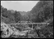
Road bridge through Tāngarākau Gorge and gravesite for surveyor beneath it, circa.1916
As the river flows mainly through remote areas there are only five bridges across the river along its entire length.
- In the upper reaches in the Waitaanga Forest there is a swing bridge on the Tatu Track
- State Highway 43 crosses the river three times as it winds through Tāngarākau Gorge
- A rail bridge on the Stratford–Okahukura Line crosses the river at the small settlement of Tāngarākau
See also
References
"Place name detail: Tāngarākau River". New Zealand Gazetteer. New Zealand Geographic Board. Retrieved 1 September 2020.
This article is issued from Wikipedia. The text is licensed under Creative Commons - Attribution - Sharealike. Additional terms may apply for the media files.