Tehrathum District
Tehrathum District (Nepali: तेह्रथुम जिल्ला pronounced [teɾʌtʰum] ⓘ), is one of 14 districts of Koshi Province of Nepal.
Tehrathum District
तेह्रथुम | |
|---|---|
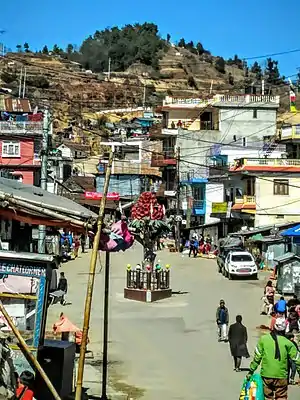 Basantapur Bazar, Tehrathum District | |
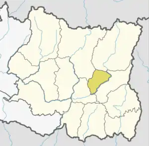 District location of Tehrathum in Koshi Province | |
| Country | |
| Province | Koshi Province |
| Admin HQ. | Myanglung |
| Government | |
| • Type | Coordination committee |
| • Body | DCC, Tehrathum |
| Area | |
| • Total | 679 km2 (262 sq mi) |
| Time zone | UTC+05:45 (NPT) |
| Telephone Code | 0092 |
| Website | ddctehrathum.gov.np |
Demographics
| Year | Pop. | ±% p.a. |
|---|---|---|
| 1981 | 92,454 | — |
| 1991 | 102,870 | +1.07% |
| 2001 | 113,111 | +0.95% |
| 2011 | 101,577 | −1.07% |
| 2021 | 89,125 | −1.30% |
| Sources:[1] | ||
At the time of the 2011 Nepal census, Tehrathum District had a population of 101,577.
As their first language, 49.7% spoke Nepali, 34.6% Limbu, 6.0% Tamang, 2.2% Magar, 1.9% Gurung, 1.4% Newar, 1.4% Rai, 1.0% Sherpa, 0.6% Kulung, 0.2% Maithili, 0.2% Yakkha, 0.1% Bhujel, 0.1% Majhi, 0.1% Sanskrit, 0.1% Wambule and 0.2% other languages.[3]
Ethnicity/caste: 36.0% were Limbu, 19.2% Chhetri, 13.3% Hill Brahmin, 6.6% Tamang, 4.4% Kami, 3.1% Damai/Dholi, 2.9% Gurung, 2.9% Newar, 2.4% Magar, 1.9% Rai, 1.6% Sarki, 1.3% Gharti/Bhujel, 1.1% Sherpa, 1.0% Sanyasi/Dasnami, 0.5% Kulung, 0.3% Badi, 0.3% Majhi, 0.3% Thakuri, 0.2% Yakkha, 0.1% Sunuwar and 0.3% others.[4]
Religion: 52.2% were Hindu, 33.9% Kirati, 12.5% Buddhist, 1.0% Christian, 0.1% Prakriti and 0.2% others.[6]
Literacy: 74.4% could read and write, 2.2% could only read and 23.3% could neither read nor write.[7]
Geographics
| Climate Zone[8] | Elevation Range | % of Area |
|---|---|---|
| Upper Tropical | 300 to 1,000 meters 1,000 to 3,300 ft. |
24.0% |
| Subtropical | 1,000 to 2,000 meters 3,300 to 6,600 ft. |
56.4% |
| Temperate | 2,000 to 3,000 meters 6,400 to 9,800 ft. |
19.5% |
Division
Tehrathum District consists of the following six subdivisions:[9]
| Local body | Nepali | Type | Population (2011) |
|---|---|---|---|
| Aathrai | आठराई | Rural municipality | 18,156 |
| Chhathar | छथर | Rural municipality | 14,197 |
| Laligurans | लालीगुराँस | Municipality | 15,329 |
| Menchhayayem | मेन्छयायेम | Rural municipality | 6,678 |
| Myanglung | म्याङलुङ | Municipality | 18,750 |
| Phedap | फेदाप | Rural municipality | 15,169 |
See also
References
- "Nepal: Provinces and Districts". www.citypopulation.de.
- "NepalMap profile: Terhathum". NepalMap. Retrieved 17 July 2022.
- NepalMap Language
- NepalMap Caste
- "NepalMap profile: Terhathum". NepalMap. Retrieved 17 July 2022.
- NepalMap Religion
- NepalMap Literacy
- The Map of Potential Vegetation of Nepal - a forestry/agroecological/biodiversity classification system (PDF), Forest & Landscape Development and Environment Series 2-2005 and CFC-TIS Document Series No.110., 2005, ISBN 87-7903-210-9, retrieved Nov 22, 2013
- "Nepal: Municipal Division (Districts and Local Units) - Population Statistics, Charts and Map". www.citypopulation.de. Retrieved 2023-03-28.
- "Districts of Nepal". Statoids.
External links
Places adjacent to Tehrathum District | ||||||||||||||||
|---|---|---|---|---|---|---|---|---|---|---|---|---|---|---|---|---|
| ||||||||||||||||