Totness, Suriname
Totness is a town in Suriname, located in the Coronie district, of which it is the capital. Totness is the oldest settlement in the district.[2]
Totness | |
|---|---|
Resort and town | |
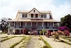
 District Commissioner's Office in Totness | |
 Map showing the resorts of Coronie District. Totness is in yellow | |
| Coordinates: 5°52′39″N 56°19′45″W | |
| Country | |
| District | Coronie District |
| Settled | 1808 |
| Area | |
| • Total | 173 km2 (67 sq mi) |
| Elevation | 0 m (0 ft) |
| Population (2012)[1] | |
| • Total | 2,150 |
| • Density | 12/km2 (32/sq mi) |
| Time zone | UTC-3 (AST) |
History
Totness was settled by Scottish and English colonists from 1808 onward, and is named after Totnes, England.[3][2] In 1863, the area around Totness was designated for independent agriculture.[4] A market and a District Commissioner's Office on the former plantation Friendship were added to the resort. In the 1940s, a road was built linking Totness with Paramaribo which is nowadays part of the East-West Link.[5]
The Suriname-Guyana Submarine Cable System has its landing station in Totness. It connects the telecommunications networks in Suriname with those in Guyana and Trinidad and from Trinidad to the rest of the world.[6] The Totness Airstrip is one of the oldest airports in Suriname, in use since 1953, when the Piper Cub (PZ-NAC) of Kappel-van Eyck named "Colibri" landed there from Zorg en Hoop Airport.[7]
Totness has been designated as a regional centre, and is planned to be upgrade with a medium sized hotel and a proper city centre.[8] The village of Friendship is located is on the north side of the East-West link, and Totness is to the south.
Sports
The Letitia Vriesde Sportcomplex is a multi-purpose stadium located in Totness. It is home to SVB Eerste Klasse club F.C. West United.[9]
Tata Colin
Tata Colin (circa 1806 - 1836) was a slave on the plantation Leasowes near Totness. In 1835, he attempted a slave rebellion. His intention was to free all the slaves, but he was betrayed, taken to Paramaribo where he was tortured and tried.[10] Colin was taken to Fort Zeelandia to be hung, but died[11][12] or vanished using black magic,[10] before his sentence was carried out. His followers were sentenced to hard labour or public corporal punishment.[12]
A statue had been erected to Tata Colin in the central square of Totness, and the local school had been named after him.[13]
Notable people
- Jozef Slagveer (1940–1982), journalist, and a victim of the December murders.[14]
- Michaël Slory (1935–2018), poet mainly in Sranan Tongo[15]
- Ervin Tjon-A-Loi (born 1995), footballer[16]
- Letitia Vriesde (born 1964), athlete[17]
- Emile Wijntuin (1924–2020), Chairman of the National Assembly of Suriname.[18]
Gallery
.jpg.webp) Church of Totness
Church of Totness Hidden house (1967)
 House in Totness
%252C_NG-1994-65-1-28-1.jpg.webp) Harbour of Totness (1906-1913)
Harbour of Totness (1906-1913)
References
- "Resorts in Suriname Census 2012" (PDF). Retrieved 19 May 2020.
- "Geschiedenis van Coronie". Coronie.nl (in Dutch). Retrieved 8 May 2020.
- Tessa Leuwsha, Reishandboek Suriname, ISBN 9789038924939, 2017
- "Encyclopaedie van Nederlandsch West-Indië - Page 441 - Landbouw" (PDF). Digital Library for Dutch Literature (in Dutch). 1916. Retrieved 5 May 2020.
- "Totness". Coronie.nl (in Dutch). Retrieved 8 May 2020.
- Submarine Telecoms Forum, Issue 52, retrieved August 1, 2010
- "Flying on trusted wings". Issuu (in Dutch). Retrieved 9 May 2020.
- "STRUCTUUR ANALYSE DISTRICTEN 2009-2013" (PDF). Planning Office Suriname (in Dutch). Retrieved 22 May 2020.
- "Stadiums in Suriname". Worldstadiums.com. Archived from the original on 6 October 2012. Retrieved 6 April 2016.
- Digital Library for Dutch Literature, Ruud Mungroo (1982). "Tata Colin" (in Dutch). Retrieved 8 May 2020.
- "Tata Colin". Spangle Fish. Retrieved 8 May 2020.
- "OSO. Tijdschrift voor Surinaamse taalkunde, letterkunde en geschiedenis. Jaargang 13" (in Dutch). 1994. Retrieved 21 May 2020.
- "Monuments". Anda Suriname (in Dutch). Retrieved 17 May 2020.
- Jozef Slagveer, Digital Library for Dutch Literature. "totness" (in Dutch). Retrieved 9 May 2020.
- Michaël Slory, Digital Library for Dutch Literature. "Ik zal zingen om de zon te laten opkomen" (in Dutch). Retrieved 17 May 2020.
- Ervin Tjon-A-Loi at National-Football-Teams.com
- "Letitia Vriesde". Suriname Athletics (in Dutch). Retrieved 7 May 2020.
- "Emile Wijntuin viert 90ste verjaardag". Suriname Herald (in Dutch). Retrieved 9 May 2020.
