City of Winchester
Winchester (/ˈwɪntʃɪstər/),[1] commonly known as the City of Winchester, is a non-metropolitan district in Hampshire, England, with city status.
City of Winchester | |
|---|---|
| Winchester | |
 | |
 Coat of arms Council logo | |
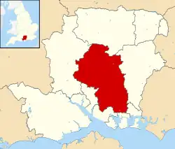 Winchester shown within Hampshire | |
| Sovereign state | United Kingdom |
| Country | England |
| Region | South East England |
| Non-metropolitan county | Hampshire |
| Status | Non-metropolitan district, Borough, City time immemorial |
| Admin HQ | Winchester |
| Incorporated | 1 April 1974 |
| Government | |
| • Type | Non-metropolitan district council |
| • Body | Winchester City Council |
| • Leadership | Leader & Cabinet (Liberal Democrat) |
| • MPs | Steve Brine Flick Drummond |
| Area | |
| • Total | 255.20 sq mi (660.97 km2) |
| • Rank | 51st (of 296) |
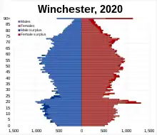
| Population (2021) | |
| • Total | 127,916 |
| • Rank | 184th (of 296) |
| • Density | 500/sq mi (190/km2) |
| • Ethnicity | 97.8% White |
| Time zone | UTC0 (GMT) |
| • Summer (DST) | UTC+1 (BST) |
| ONS code | 24UP (ONS) E07000094 (GSS) |
| OS grid reference | SU485295 |
| Website | www |
.jpg.webp)
The district covers the city of Winchester, which it is named after, and a large area of central Hampshire including Bishop's Waltham, Denmead, New Alresford, and Kings Worthy (for a full list of these, see the "Settlements and parishes" section below), for a total area of 255.2 square miles (661 km2). The 2011 Census recorded the population of the district as 116,600.[2]
The district was formed on 1 April 1974, under the Local Government Act 1972, by the merger of the borough of Winchester with Droxford rural district and part of Winchester rural district. It borders Basingstoke and Deane to the north, East Hampshire to the east, the borough of Havant and the unitary authority area of Portsmouth to the south-east, the borough of Fareham to the south, the borough of Eastleigh to the south-west, and Test Valley to the west.
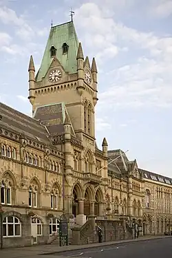
The city traces its history to the Roman Era, developing from the town of Venta Belgarum. It saw historic significance from its reconstruction under Alfred the Great in the 9th century, and grew in prominence until London replaced it as capital; Winchester saw a decline after plague swept the country, but began to recover from the 19th century.
Governance
Parliamentary constituencies
The City of Winchester is made up of two parliamentary constituencies. Winchester constituency covers the north-eastern part of the city, as well as Chandler's Ford, which is part of Eastleigh. The remainder constitutes Meon Valley, which also covers part of East Hampshire and Havant. Winchester constituency has been represented by Steve Brine since 2010, whilst Meon Valley has been represented by Flick Drummond since the 2019 general election.
Winchester City Council
Elections to the council are held in three out of every four years, with one third of the seats on the council being elected at each election. From 1995 to the 2004 election the Liberal Democrats had a majority on the council, but after 2 years when no party held a majority the 2006 election saw the Conservative party gain control.[3] The elections on 6 May 2010 saw the Liberal Democrats re take control of the council, however the council soon switched to NOC a year later in 2011. In 2012, the Conservative Party made their only Council gain of the entire English local elections and won a majority in Winchester once again.[4] Subsequently, two Conservative councillors defected to the Liberal Democrat group, placing the council under No Overall Control.[5] Following local elections on 7 May 2015, the Conservatives re-gained majority control of the council.[6] Since the 2016 council election, in which new boundaries were introduced, no other parties than the Conservative and Liberal Democrats have held seats on the council. After the local elections on 2 May 2019, the Liberal Democrats gained majority control. Three independent councillors were elected as Conservatives. Cllr Weston resigned from the party in late 2019.[7] Cllr Clementson was suspended from the party pending an investigation.[8] Due to the COVID-19 pandemic, the scheduled 2020 local elections were postponed until 2021, when they took place alongside elections for Hampshire County Council. In November 2020 Alresford & Itchen Valley councillor Lisa Griffiths resigned from the Conservative Party to sit as an independent.[9] In September 2020, Liberal Democrat Councillor Kim Gottlieb (who joined the party after leaving the Conservatives) resigned as a Councillor, leaving one of the three St Michael seats vacant. The vacancy was subsequently won in 2021 City Council election by the Liberal Democrats, who retained an overall majority on the council despite losing a seat to the Conservatives.
The council is currently led by a Liberal Democrat administration. The make up of the council as of August 2023 is:[7]
- Liberal Democrats - 30
- Conservative Party - 12
- Green Party - 2
- Independent - 1
| Ward | Party | Member | Election | |
|---|---|---|---|---|
| Alresford & Itchen Valley | Liberal Democrat | Russell Gordon-Smith | 2023 | |
| Liberal Democrat | Margot Power | 2022 | ||
| Conservative | Fiona Isaacs | 2021 | ||
| Badger Farm & Oliver's Battery | Liberal Democrat | Adrian Brophy | 2023 | |
| Liberal Democrat | Brian Laming | 2022 | ||
| Conservative | Jan Warwick | 2021 | ||
| Bishops Waltham | Liberal Democrat | Jonathan Williams | 2023 | |
| Conservative | Steve Miller | 2022 | ||
| Conservative | Michael Kurn | 2021 | ||
| Central Meon Valley | Green | Danny Lee | 2023 | |
| Green | Malcolm Wallace | 2022 | ||
| Conservative | Frank Pearson | 2021 | ||
| Colden Common and Twyford | Liberal Democrat | Hannah Greenberg | 2023 | |
| Independent[10][n 1] | Sue Cook | 2022 | ||
| Denmead | Conservative | Paula Langford-Smith | 2023 | |
| Conservative | Caroline Brook | 2022 | ||
| Conservative | Mike Read | 2021 | ||
| Southwick and Wickham | Liberal Democrat | Chris Chamberlain | 2023 | |
| Liberal Democrat | Neil Cutler | 2022 | ||
| Liberal Democrat | Angela Clear | 2021 | ||
| St Barnabas | Liberal Democrat | Jonny Morris | 2023 | |
| Liberal Democrat | James Batho | 2022 | ||
| Liberal Democrat | Kelsie Learney | 2021 | ||
| St Bartholomew | Liberal Democrat | Nathan Eve | 2023 | |
| Liberal Democrat | Kathleen Becker | 2022 | ||
| Liberal Democrat | John Tippett-Cooper | 2021 | ||
| St Luke | Liberal Democrat | Charlie Wise | 2023 | |
| Liberal Democrat[11][n 2] | Jamie Scott | 2021 | ||
| St Michael | Liberal Democrat | George Prest | 2023 | |
| Liberal Democrat | Mark Reach | 2022 | ||
| Liberal Democrat | Chris Edwards | 2021 | ||
| St Paul | Liberal Democrat | Martin Tod | 2023 | |
| Liberal Democrat | Lucille Thompson | 2022 | ||
| Liberal Democrat | Chris Westwood | 2021 | ||
| The Worthys | Liberal Democrat | Jane Rutter | 2023 | |
| Liberal Democrat | Jackie Porter | 2022 | ||
| Liberal Democrats | Steve Cramoysan | 2021 | ||
| Upper Meon Valley | Liberal Democrat | Jerry Pett | 2023 | |
| Conservative | Neil Bolton | 2022 | ||
| Whiteley & Shedfield | Liberal Democrats | Sudhakar Achwal | 2023 | |
| Liberal Democrats | Anne Small | 2022 | ||
| Liberal Democrats | Vivian Achwal | 2021 | ||
| Wonston & Micheldever | Conservative | Caroline Horrill | 2023 | |
| Conservative | Partrick Cunningham | 2022 | ||
| Conservative | Stephen Godfrey | 2021 | ||
County Council
Hampshire County Council holds elections every four years. Several Councillors are members of both the City and County Councils. In the 2021 elections the Winchester City district area elected seven representatives, out of 78:
| Ward | Party | Member[12] | |
|---|---|---|---|
| Winchester Eastgate | Liberal Democrat | Dominic Charles Alan Hiscock | |
| Winchester Downlands | Conservative | Jan Warwick | |
| Winchester Westgate | Liberal Democrat | Martin Tod | |
| Winchester Southern Parishes | Conservative | Patricia Stallard | |
| Itchen Valley | Liberal Democrat | Jackie Porter | |
| Meon Valley | Conservative | Hugh Lumby | |
| Bishop's Waltham | Conservative | Rob Humby | |
Demographics
A Legatum Prosperity Index published by the Legatum Institute in October 2016 showed the City of Winchester as the third most prosperous council area in the United Kingdom, after the Borough of Waverley and Mole Valley.[13]
Ethnicity
| Ethnic Group | 1991[14] | 2001[15] | 2011[16] | |||
|---|---|---|---|---|---|---|
| Number | % | Number | % | Number | % | |
| White: Total | 95,427 | 99% | 104,907 | 97.8% | 111,577 | 95.7% |
| White: British | – | – | 101,689 | 94.8% | 107,070 | 91.8% |
| White: Irish | – | – | 750 | 733 | ||
| White: Gypsy or Irish Traveller | – | – | – | – | 263 | |
| White: Other | – | – | 2,468 | 3,511 | ||
| Asian or Asian British: Total | 563 | 0.6% | 1,063 | 1% | 2,639 | 2.3% |
| Asian or Asian British: Indian | 144 | 382 | 665 | |||
| Asian or Asian British: Pakistani | 31 | 44 | 92 | |||
| Asian or Asian British: Bangladeshi | 80 | 180 | 222 | |||
| Asian or Asian British: Chinese | 142 | 324 | 745 | |||
| Asian or Asian British: Other Asian | 166 | 133 | 915 | |||
| Black or Black British: Total | 147 | 0.2% | 270 | 0.3% | 457 | 0.4% |
| Black or Black British: Caribbean | 54 | 118 | 147 | |||
| Black or Black British: African | 41 | 126 | 250 | |||
| Black or Black British: Other Black | 52 | 26 | 60 | |||
| Mixed or British Mixed: Total | – | – | 708 | 0.7% | 1,626 | 1.4% |
| Mixed: White and Black Caribbean | – | – | 142 | 321 | ||
| Mixed: White and Black African | – | – | 86 | 180 | ||
| Mixed: White and Asian | – | – | 283 | 684 | ||
| Mixed: Other Mixed | – | – | 197 | 441 | ||
| Other: Total | 249 | 0.3% | 274 | 0.3% | 296 | 0.3% |
| Other: Arab | – | – | – | – | 110 | |
| Other: Any other ethnic group | 249 | 0.3% | 274 | 0.3% | 186 | |
| Total | 96,386 | 100% | 107,222 | 100% | 116,595 | 100% |
Settlements and parishes
Settlements in the district include:
- Abbotts Barton, Abbots Worthy, Avington
- Badger Farm, Beauworth, Bighton, Bishops Sutton, Bishops Waltham, Boarhunt, Bramdean, Brockwood Park
- Cheriton, Chilcomb, Colden Common, Compton and Shawford, Corhampton, Crawley, Curdridge
- Denmead, Droxford, Durley
- Easton, Exton
- Hambledon, Headbourne Worthy, Hinton Ampner, Hursley
- Itchen Abbas, Itchen Stoke, Itchen Valley
- Kilmeston, Kings Worthy
- Littleton and Harestock
- Martyr Worthy, Meonstoke, Micheldever, Morestead
- New Alresford, Northington
- Old Alresford, Olivers Battery, Otterbourne, Ovington, Owslebury
- Shedfield, Soberton, Southwick, South Wonston, Sparsholt, Stoke Charity, Sutton Scotney, Swanmore
- Tichborne, Twyford
- Upham
- Warnford, West Meon, Whiteley (part), Wickham, Widley, Winchester, Winnall, Wonston
Parishes
| Council | Equivalent City Ward |
|---|---|
| Badger Farm | Badger Farm & Olivers Battery |
| Beauworth | Upper Meon Valley |
| Bighton | Alresford & Itchen Valley |
| Bishop's Waltham | Bishop's Waltham |
| Bishops Sutton | Alresford & Itchen Valley |
| Boarhunt | Southwick & Wicham |
| Bramdean and Hinton Ampner | Upper Meon Valley |
| Cheriton | Upper Meon Valley |
| Chilcomb | Upper Meon Valley |
| Colden Common | Colden Common & Twyford |
| Compton & Shawford | Badger Farm & Oliver's Battery |
| Corhampton & Meonstoke | Upper Meon Valley |
| Crawley | Wonston & Micheldever |
| Curdridge | Whiteley & Shedfield |
| Denmead | Denmead |
| Droxford | Central Meon Valley |
| Durley | Bishop's Waltham |
| Exton | Upper Meon Valley |
| Hambledon | Central Meon Valley |
| Headbourne Worthy | The Worthys |
| Hursley | Badger Farm & Oliver's Battery |
| Itchen Stoke & Ovington | Alresford & Itchen Valley |
| Itchen Valley | Alresford & Itchen Valley |
| Kilmeston | Upper Meon Valley |
| Kings Worthy | The Worthys |
| Littleton and Harestock | Wonston & Micheldever |
| Micheldever | Wonston & Micheldever |
| New Alresford (Town) | Alresford & Itchen Valley |
| Newlands | Denmead |
| Southwick & Wickham | |
| Northington | Alresford & Itchen Valley |
| Old Alresford | Alresford & Itchen Valley |
| Oliver's Battery | Badger Farm & Oliver's Battery |
| Otterbourne | Badger Farm & Oliver's Battery |
| Owslebury | Upper Meon Valley |
| Shedfield | Whiteley & Shedfield |
| Central Meon Valley | |
| Soberton | Central Meon Valley |
| South Wonston | Wonston & Micheldever |
| The Worthys | |
| Southwick & Widley | Southwick & Wickham |
| Sparsholt | Wonston & Micheldever |
| Swanmore | Central Meon Valley |
| Tichborne | Upper Meon Valley |
| Twyford | Colden Common & Twyford |
| Upham | Upper Meon Valley |
| Warnford | Upper Meon Valley |
| West Meon | Upper Meon Valley |
| Whiteley | Whiteley & Shedfield |
| Wickham | Southwick & Wickham |
| Wonston | Wonston & Micheldever |
Notes
- Elected as a Conservative
- Elected as a Conservative
References
- "Local Authority Districts, Counties and Unitary Authorities (April 2021) Map in United Kingdom". Office for National Statistics: Open Geography Portal. Retrieved 1 August 2023.
- "Population figures". Winchester City Council. 14 July 2017. Retrieved 24 October 2020.
- "Local elections: Winchester". BBC News Online. Retrieved 4 February 2010.
- "City Councillors". Winchester City Council. Archived from the original on 18 February 2010. Retrieved 29 May 2010.
- Rea, Robin (22 January 2014). "Two Conservative Councillors join the Liberal Democrats". Winchester Liberal Democrats. Archived from the original on 27 January 2014. Retrieved 22 January 2014.
- "Your Councillors by Ward". Winchester.gov.uk. Winchester City Council. 2015. Retrieved 5 August 2015.
- "Your Councillors". Winchester City Council. 10 July 2022. Retrieved 10 July 2022.
- "Conservative Denmead councillor suspended from party accused of Islamophobic posts on anonymous Twitter account". portsmouth.co.uk. Retrieved 7 August 2020.
- "City councillor resigns from Tories over fears work could embarrass party". Hampshire Chronicle. Retrieved 20 November 2020.
- "City councillor resigns from the Conservatives to better represent residents". Hampshire Chronicle. 27 January 2023. Retrieved 18 August 2023.
- "Councillor switches allegiance to rival party". Hampshire Chronicle. 24 February 2023. Retrieved 18 August 2023.
- "County Council Election 2017 - Thursday, 4th May, 2017". Hantsweb. Hampshire County Council. 4 May 2017. Retrieved 29 October 2018.
- Braiden, Gerry (13 October 2016). "Scots authority named amongst UK's top 10 most prosperous – as neighbouring city props up table". HeraldScotland. Retrieved 6 December 2010.
- Data is taken from United Kingdom Casweb Data services of the United Kingdom 1991 Census on Ethnic Data for England, Scotland and Wales (Table 6)
- "Office of National Statistics; 2001 Census Key Statistics". webarchive.nationalarchives.gov.uk. Retrieved 7 September 2021.
- "2011 Census: Ethnic Group, local authorities in England and Wales". webarchive.nationalarchives.gov.uk. Retrieved 15 December 2021.
- "Map of Hampshire (Electoral Changes) Order, 2016" (PDF). The Local Government Boundary Commission for England. 2016. Retrieved 29 October 2018.


Electoral Wards and Parishes in the City of Winchester District, Hampshire, England (since 2016 boundary changes) | ||
|---|---|---|
| Wonston and Micheldever | ||
| The Worthys | ||
| Alresford and Itchen | ||
| Winchester |
| |
| Badger Farm and Oliver's Battery | ||
| Colden Common and Twyford | ||
| Upper Meon Valley | ||
| Bishops Waltham | ||
| Central Meon Valley | ||
| Whiteley and Shedfield | ||
| Denmead | ||
| Southwick and Wickham | ||
(Wards ordered from north-west corner, across the map, and then progressively south and east) | ||