Île de Batz
The Île de Batz (French pronunciation: [il də ba]; Breton: Enez-Vaz) is an island off Roscoff in Brittany, France. Administratively, it is a commune in the Finistère department of Brittany in north-western France.
Île-de-Batz
Enez-Vaz | |
|---|---|
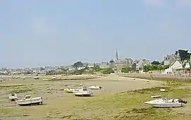 Porz Kernog on Île de Batz | |
 Flag .svg.png.webp) Coat of arms | |
Location of Île-de-Batz | |
 Île-de-Batz  Île-de-Batz | |
| Coordinates: 48°44′43″N 4°00′35″W | |
| Country | France |
| Region | Brittany |
| Department | Finistère |
| Arrondissement | Morlaix |
| Canton | Saint-Pol-de-Léon |
| Government | |
| • Mayor (2021–2026) | Eric Grall[1] |
| Area 1 | 3.05 km2 (1.18 sq mi) |
| Population | 450 |
| • Density | 150/km2 (380/sq mi) |
| Time zone | UTC+01:00 (CET) |
| • Summer (DST) | UTC+02:00 (CEST) |
| INSEE/Postal code | 29082 /29253 |
| Elevation | 0–33 m (0–108 ft) |
| 1 French Land Register data, which excludes lakes, ponds, glaciers > 1 km2 (0.386 sq mi or 247 acres) and river estuaries. | |
Climate
Île de Batz has a oceanic climate (Köppen climate classification Cfb). The average annual temperature in Île de Batz is 12.0 °C (53.6 °F). The average annual rainfall is 894.4 mm (35.21 in) with December as the wettest month. The temperatures are highest on average in August, at around 17.0 °C (62.6 °F), and lowest in February, at around 7.7 °C (45.9 °F). The highest temperature ever recorded in Île de Batz was 35.0 °C (95.0 °F) on 18 August 1932; the coldest temperature ever recorded was −10.0 °C (14.0 °F) on 14 February 1929 and 18 December 1927.
| Town | Sunshine (hours/yr) |
Rain (mm/yr) | Snow (days/yr) | Storm (days/yr) | Fog (days/yr) |
|---|---|---|---|---|---|
| National average | 1,973 | 770 | 14 | 22 | 40 |
| Île de Batz | 1,735.2 | 872.3 | 4.0 | 5.2 | 26.6[4] |
| Paris | 1,661 | 637 | 12 | 18 | 10 |
| Nice | 2,724 | 767 | 1 | 29 | 1 |
| Strasbourg | 1,693 | 665 | 29 | 29 | 56 |
| Brest | 1,605 | 1,211 | 7 | 12 | 75 |
| Climate data for Île de Batz (1981–2010 averages, extremes 1917−present) | |||||||||||||
|---|---|---|---|---|---|---|---|---|---|---|---|---|---|
| Month | Jan | Feb | Mar | Apr | May | Jun | Jul | Aug | Sep | Oct | Nov | Dec | Year |
| Record high °C (°F) | 17.7 (63.9) |
19.8 (67.6) |
24.3 (75.7) |
26.8 (80.2) |
29.5 (85.1) |
31.9 (89.4) |
34.0 (93.2) |
35.0 (95.0) |
31.6 (88.9) |
30.2 (86.4) |
19.6 (67.3) |
18.8 (65.8) |
35.0 (95.0) |
| Average high °C (°F) | 9.9 (49.8) |
9.9 (49.8) |
11.4 (52.5) |
12.6 (54.7) |
14.9 (58.8) |
17.4 (63.3) |
19.3 (66.7) |
19.7 (67.5) |
18.4 (65.1) |
15.9 (60.6) |
12.8 (55.0) |
10.7 (51.3) |
14.4 (57.9) |
| Daily mean °C (°F) | 7.9 (46.2) |
7.7 (45.9) |
9.0 (48.2) |
10.0 (50.0) |
12.4 (54.3) |
14.7 (58.5) |
16.6 (61.9) |
17.0 (62.6) |
15.8 (60.4) |
13.5 (56.3) |
10.6 (51.1) |
8.6 (47.5) |
12.0 (53.6) |
| Average low °C (°F) | 5.8 (42.4) |
5.5 (41.9) |
6.7 (44.1) |
7.5 (45.5) |
9.8 (49.6) |
12.1 (53.8) |
13.9 (57.0) |
14.2 (57.6) |
13.1 (55.6) |
11.1 (52.0) |
8.4 (47.1) |
6.4 (43.5) |
9.6 (49.3) |
| Record low °C (°F) | −9.2 (15.4) |
−10.0 (14.0) |
−4.2 (24.4) |
−1.0 (30.2) |
0.8 (33.4) |
4.0 (39.2) |
6.0 (42.8) |
6.4 (43.5) |
4.4 (39.9) |
1.0 (33.8) |
−4.4 (24.1) |
−10.0 (14.0) |
−10.0 (14.0) |
| Average precipitation mm (inches) | 101.7 (4.00) |
81.9 (3.22) |
71.2 (2.80) |
65.7 (2.59) |
61.3 (2.41) |
48.5 (1.91) |
45.5 (1.79) |
48.2 (1.90) |
54.5 (2.15) |
97.0 (3.82) |
102.5 (4.04) |
116.4 (4.58) |
894.4 (35.21) |
| Average precipitation days (≥ 1.0 mm) | 16.1 | 12.6 | 12.8 | 11.9 | 10.3 | 8.3 | 8.3 | 8.5 | 8.9 | 13.9 | 15.8 | 17.0 | 144.3 |
| Average relative humidity (%) | 83 | 82 | 82 | 82 | 84 | 84 | 85 | 85 | 85 | 84 | 82 | 83 | 83.4 |
| Mean monthly sunshine hours | 59.1 | 85.0 | 127.3 | 172.5 | 215.8 | 210.7 | 234.3 | 211.5 | 167.6 | 121.2 | 75.1 | 55.1 | 1,735.2 |
| Source: Meteociel,[5] Infoclimat.fr (humidity and sunshine 1961-1990)[6] | |||||||||||||
Population
Inhabitants of Île-de-Batz are called in French Batziens or Îliens.
At the census of 1999 the island had a population of 575, and in 2005 it had an estimated population of 594.

See also
References
- "Répertoire national des élus: les maires" (in French). data.gouv.fr, Plateforme ouverte des données publiques françaises. 4 May 2022.
- "Populations légales 2020". The National Institute of Statistics and Economic Studies. 29 December 2022.
- Paris, Nice, Strasbourg, Brest
- "Normales climatiques 1981-2010 : Île de Batz". www.lameteo.org. Retrieved 2 June 2022.
- "Normales et records pour Batz (29)". Meteociel. Retrieved 2 June 2022.
- "Normes et records 1961-1990: Ile de Batz (29) - altitude 27m" (in French). Infoclimat. Archived from the original on 15 March 2016. Retrieved 30 December 2015.
External links
- Official website (in French)
- Cultural Heritage (in French)
- Base Mérimée: Search for heritage in the commune, Ministère français de la Culture. (in French)
- Official website of colonie du phare (in French)