Administrative divisions of Donetsk Oblast
Donetsk Oblast is subdivided into districts (raions) which are further subdivided into territorial communities (hromadas).
Current

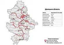
On 18 July 2020, the number of districts was reduced to eight.[1][2] This includes territories not under control of Ukrainian government, where the old territorial division is in use. The eight districts are:
- Bakhmut (Бахмутський район), the center is in the city of Bakhmut;
- Donetsk (Донецький район), the center is in the city of Donetsk;
- Horlivka (Горлівський район), the center is in the city of Horlivka;
- Kalmiuske (Кальміуський район), the center is in the city of Kalmiuske;
- Kramatorsk (Краматорський район), the center is in the city of Kramatorsk;
- Mariupol (Маріупольський район), the center is in the city of Mariupol;
- Pokrovsk (Покровський район), the center is in the city of Pokrovsk;
- Volnovakha (Волноваський район), the center is in the city of Volnovakha.
| Donetsk Oblast | |
| As of January 1, 2022 | |
| Number of districts (райони) | 8 |
| Number of hromadas (громади) | 66 |
Administrative divisions until 2020


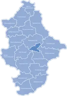
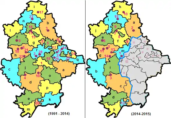
Districts (raions): a – Amvrosiivka, b – Bakhmut, c – Velyka Novosilka, d – Volnovakha, e – Nikolske, f – Dobropillia, g – Kostiantynivka, h – Pokrovsk, i – Lyman, j – Marinka, k – Novoazovsk, l – Oleksandrivka, m – Manhush, n – Sloviansk, o – Starobesheve, p – Telmanove, q – Shakhtarsk, r – Yasynuvata,
Cities of regional significance: 1 – Donetsk, 2 – Avdiivka, 3 – Bakhmut, 4 – Vuhledar, 5 – Horlivka, 6 – Debaltseve, 7 – Toretsk, 8 – Myrnohrad, 9 – Dobropillia, 10 – Dokuchaievsk, 11 – Druzhkivka, 12 – Yenakiieve, 13 – Zhdanivka, 14 – Kirovske, 15 – Kostiantynivka, 16 – Kramatorsk, 17 – Lyman, 18 – Pokrovsk, 19 – Makiivka, 20 – Mariupol, 21 – Novohrodivka, 22 – Selydove, 23 – Sloviansk, 24 – Snizhne, 25 – Torez, 26 – Khartsyzk, 27 – Shakhtarsk, 28 – Yasynuvata
Until 2020, Donetsk Oblast was subdivided into 46 regions: 18 districts (raions) and 28 city municipalities (mis'krada or misto), officially known as "territories governed by city councils".[3][4] In 2014, the War in Donbas started, and whereas some areas are controlled by the central Ukrainian government, others are under control of separatists representing Donetsk People's Republic. The pro-Ukrainian government of the oblast was relocated from Donetsk to Mariupol.
- Cities under the oblast's jurisdiction:
- Donetsk municipality
- Cities under the city's jurisdiction:
- Urban-type settlements under the city's jurisdiction:
- Horbachevo-Mykhaylivka (Горбачево-Михайлівка)
- Laryne (Ларине)
- Avdiivka (Авдіївка)
- Bakhmut municipality
- Cities under the city's jurisdiction:
- Urban-type settlements under the city's jurisdiction:
- Krasna Hora (Красна Гора)
- Debaltseve (Дебальцеве)
- Dobropillia municipality
- Cities under the city's jurisdiction:
- Bilozerske (Білозерське)
- Bilytske (Білицьке)
- Dobropillia (Добропілля)
- Urban-type settlements under the city's jurisdiction:
- Novodonetske (Новодонецьке)
- Vodianske (Водянське)
- Cities under the city's jurisdiction:
- Dokuchaievsk municipality
- Cities under the city's jurisdiction:
- Dokuchaievsk (Докучаєвськ)
- Cities under the city's jurisdiction:
- Druzhkivka municipality
- Cities under the city's jurisdiction:
- Druzhkivka (Дружківка)
- Urban-type settlements under the city's jurisdiction:
- Novohryhorivka (Новогригорівка)
- Novomykolaivka (Новомиколаївка)
- Oleksiievo-Druzhkivka (Олексієво-Дружківка)
- Raiske (Райське)
- Cities under the city's jurisdiction:
- Horlivka municipality
- Cities under the city's jurisdiction:
- Horlivka (Горлівка)
- Urban-type settlements under the city's jurisdiction:
- Holmivskyi (Гольмівський)
- Panteleimonivka (Пантелеймонівка)
- Cities under the city's jurisdiction:
- Khartsyzk municipality
- Cities under the city's jurisdiction:
- Urban-type settlements under the city's jurisdiction:
- Hirne (Гірне)
- Mykolaivka (Миколаївка)
- Pokrovka (Покровка)
- Shakhtne (Шахтне)
- Shyroke (Широке)
- Troitsko-Khartsyzsk (Троїцько-Харцизьк)
- Voykove (Войкове)
- Zuivka (Зуївка)
- Kirovske (Кіровське)
- Kostiantynivka (Костянтинівка)
- Kramatorsk municipality
- Cities under the city's jurisdiction:
- Kramatorsk (Краматорськ)
- Urban-type settlements under the city's jurisdiction:
- Bilenke (Біленьке)
- Komyshuvakha (Комишуваха)
- Krasnotorka (Красноторка)
- Malotaranivka (Малотаранівка)
- Oleksandrivka (Олександрівка)
- Shabelkivka (Шабельківка)
- Sofiivka (Софіївка)
- Yasna Poliana (Ясна Поляна)
- Yasnohirka (Ясногірка)
- Cities under the city's jurisdiction:
- Lyman municipality[5]
- Cities under the city's jurisdiction:
- Urban-type settlements under the city's jurisdiction:
- Drobysheve (Дробишеве)
- Novoselivka (Новоселівка)
- Yampil (Ямпіль)
- Yarova (Ярова)
- Zarichne (Зарiчне), formerly Kirovsk[5]
- Makiivka municipality
- Cities under the city's jurisdiction:
- Makiivka (Макіївка)
- Urban-type settlements under the city's jurisdiction:
- Hruzko-Lomivka (Грузько-Ломівка)
- Hruzko-Zorianske (Грузько-Зорянське)
- Huselske (Гусельське)
- Kolosnykove (Колосникове)
- Krasnyi Oktiabr (Красний Октябр)
- Krynychna (Кринична)
- Lisne (Лісне)
- Maiak (Маяк)
- Mezhove (Межове)
- Nyzhnia Krynka (Нижня Кринка)
- Proletarske (Пролетарське)
- Sverdlove (Свердлове)
- Velyke Orikhove (Велике Оріхове)
- Vuhliar (Вугляр)
- Vysoke (Високе)
- Yasynivka (Ясинівка)
- Zemlianky (Землянки)
- Cities under the city's jurisdiction:
- Mariupol municipality
- Cities under the city's jurisdiction:
- Mariupol (Маріуполь)
- Urban-type settlements under the city's jurisdiction:
- Sartana (Сартана)
- Staryi Krym (Старий Крим)
- Talakivka (Талаківка)
- Cities under the city's jurisdiction:
- Myrnohrad municipality[6]
- Novohrodivka (Новогродівка)
- Pokrovsk municipality[6]
- Cities under the city's jurisdiction:
- Urban-type settlements under the city's jurisdiction:
- Shevchenko (Шевченко)
- Selydove municipality
- Cities under the city's jurisdiction:
- Urban-type settlements under the city's jurisdiction:
- Hostre (Гостре)
- Komyshivka (Комишівка)
- Kurakhivka (Курахівка)
- Tsukuryne (Цукурине)
- Vyshneve (Вишневе)
- Shakhtarsk municipality
- Cities under the city's jurisdiction:
- Shakhtarsk (Шахтарськ)
- Urban-type settlements under the city's jurisdiction:
- Kontarne (Контарне)
- Moskovske (Московське)
- Serdyte (Сердите)
- Stizhkivske (Стіжківське)
- Cities under the city's jurisdiction:
- Sloviansk municipality
- Cities under the city's jurisdiction:
- Sloviansk (Слов'янськ)
- Sviatohirsk (Святогірськ)
- Cities under the city's jurisdiction:
- Snizhne municipality
- Cities under the city's jurisdiction:
- Snizhne (Сніжне)
- Urban-type settlements under the city's jurisdiction:
- Andriivka (Андріївка)
- Brazhyne (Бражине)
- Hirnytske (Гірницьке)
- Lymanchuk (Лиманчук)
- Nykyforove (Никифорове)
- Pervomaiske (Первомайське)
- Pervomaiskyi (Первомайський)
- Pobieda (Побєда)
- Sieverne (Сєверне)
- Zalisne (Залісне)
- Cities under the city's jurisdiction:
- Toretsk municipality[5]
- Cities under the city's jurisdiction:
- Urban-type settlements under the city's jurisdiction:
- Kurdiumivka (Курдюмівка)
- Nelipivka (Неліпівка)
- Novhorodske (Новгородське)
- Petrivka (Петрівка)
- Pivdenne (Південне), formerly Leninske
- Pivnichne (Північне), formerly Kirove
- Shcherbynivka (Щербинівка)
- Torez municipality
- Cities under the city's jurisdiction:
- Torez (Торез)
- Urban-type settlements under the city's jurisdiction:
- Pelahiivka (Пелагіївка)
- Rozsypne (Розсипне)
- Cities under the city's jurisdiction:
- Vuhledar (Вугледар)
- Yasynuvata (Ясинувата)
- Yenakiieve municipality
- Cities under the city's jurisdiction:
- Yenakiieve (Єнакієве)
- Yunokomunarivsk (Юнокомунарівськ)
- Urban-type settlements under the city's jurisdiction:
- Druzhne (Дружне)
- Karlo-Marksove (Карло-Марксове)
- Korsun (Корсунь)
- Cities under the city's jurisdiction:
- Zhdanivka municipality
- Donetsk municipality
- Districts (raions):
- Amvrosiivka (Амвросіївський район)
- Cities under the district's jurisdiction:
- Amvrosiivka (Амвросіївка)
- Urban-type settlements under the district's jurisdiction:
- Kuteinykove (Кутейникове)
- Novoamvrosiivske (Новоамвросіївське)
- Voikovskyi (Войковський)
- Cities under the district's jurisdiction:
- Bakhmut (Бахмутський район)[5]
- Cities under the district's jurisdiction:
- Chasiv Yar (Часів Яр)
- Siversk (Сіверськ)
- Soledar (Соледар)
- Svitlodarsk (Світлодарськ)
- Vuhlehirsk (Вуглегірськ)
- Urban-type settlements under the district's jurisdiction:
- Bulavynske (Булавинське)
- Luhanske (Луганське)
- Myronivskyi (Миронівський)
- Oleksandrivske (Олександрівське)
- Olenivka (Оленівка)
- Olkhovatka (Ольховатка)
- Pryberezhne (Прибережне)
- Zaitseve (Зайцеве)
- Cities under the district's jurisdiction:
- Dobropillia (Добропільський район)
- Urban-type settlements under the district's jurisdiction:
- Sviatohorivka (Святогорівка)
- Urban-type settlements under the district's jurisdiction:
- Kostiantynivka (Костянтинівський район)
- Manhush (Мангушський район), formerly Pershotravnevyi Raion[8]
- Marinka (Мар'їнський район)
- Cities under the district's jurisdiction:
- Krasnohorivka (Красногорівка)
- Kurakhove (Курахове)
- Marinka (Мар'їнка)
- Urban-type settlements under the district's jurisdiction:
- Illinka (Іллінка)
- Oleksandrivka (Олександрівка)
- Staromykhailivka (Старомихайлівка)
- Cities under the district's jurisdiction:
- Nikolske (Нікольський район), formerly Volodarske Raion[6]
- Novoazovsk (Новоазовський район)
- Cities under the district's jurisdiction:
- Novoazovsk (Новоазовськ)
- Urban-type settlements under the district's jurisdiction:
- Siedove (Сєдове)
- Cities under the district's jurisdiction:
- Oleksandrivka (Олександрівський район)
- Urban-type settlements under the district's jurisdiction:
- Oleksandrivka (Олександрівка)
- Urban-type settlements under the district's jurisdiction:
- Pokrovsk (Покровський район), formerly Krasnoarmiisk Raion[6]
- Urban-type settlements under the district's jurisdiction:
- Hrodivka (Гродівка)
- Novoekonomichne (Новоекономічне)
- Udachne (Удачне)
- Urban-type settlements under the district's jurisdiction:
- Shakhtarsk (Шахтарський район)
- Sloviansk (Слов'янський район)
- Cities under the district's jurisdiction:
- Mykolaivka (Миколаївка)
- Urban-type settlements under the district's jurisdiction:
- Andriivka (Андріївка)
- Bylbasivka (Билбасівка)
- Cherkaske (Черкаське)
- Donetske (Донецьке)
- Raihorodok (Райгородок)
- Cities under the district's jurisdiction:
- Starobesheve (Старобешівський район)
- Cities under the district's jurisdiction:
- Komsomolske (Комсомольське)
- Urban-type settlements under the district's jurisdiction:
- Novyi Svit (Новий Світ)
- Starobesheve (Старобешеве)
- Cities under the district's jurisdiction:
- Telmanove (Тельманівський район)
- Urban-type settlements under the district's jurisdiction:
- Telmanove (Тельманове)
- Urban-type settlements under the district's jurisdiction:
- Velyka Novosilka (Великоновосілківський район)
- Urban-type settlements under the district's jurisdiction:
- Velyka Novosilka (Велика Новосілка)
- Urban-type settlements under the district's jurisdiction:
- Volnovakha (Волноваський район)
- Cities under the district's jurisdiction:
- Volnovakha (Волноваха)
- Urban-type settlements under the district's jurisdiction:
- Andriivka (Андріївка)
- Blahodatne (Благодатне)
- Donske (Донське)
- Hrafske (Графське), formerly Komsomolskyi
- Myrne (Мирне)
- Novotroitske (Новотроїцьке)
- Olenivka (Оленівка)
- Olhynka (Ольгинка)
- Volodymyrivka (Володимирівка)
- Cities under the district's jurisdiction:
- Yasynuvata (Ясинуватський район)
- Urban-type settlements under the district's jurisdiction:
- Keramik (Керамік)
- Ocheretyne (Очеретине)
- Verkhnotoretske (Верхньоторецьке)
- Zhelanne (Желанне)
- Urban-type settlements under the district's jurisdiction:
- Amvrosiivka (Амвросіївський район)
References
- "Про утворення та ліквідацію районів. Постанова Верховної Ради України № 807-ІХ". Голос України (in Ukrainian). 2020-07-18. Retrieved 2020-10-03.
- "Нові райони: карти + склад" (in Ukrainian). Міністерство розвитку громад та територій України.
- Чисельність наявного населення України (in Ukrainian). State Service of Statistics. Archived from the original on 1 July 2014. Retrieved 5 September 2014.
- "Чисельність наявного населення України (Actual population of Ukraine)" (PDF) (in Ukrainian). State Statistics Service of Ukraine. Archived from the original (PDF) on 22 June 2020. Retrieved 2 September 2020.
- "Rada de-communized Artemivsk as well as over hundred cities and villages" (in Ukrainian). Pravda.com.ua. 4 February 2016. Retrieved 4 February 2016.
- "Pro perejmenuvannja dejakih naselenih punktiv" (in Ukrainian). Holos Ukrainy. 21 May 2016. Retrieved 1 June 2016.
- "Рада перейменувала Дніпродзержинськ на Кам'янське" (in Ukrainian). Українські Національні Новини. 19 May 2016. Archived from the original on 19 May 2016. Retrieved 19 May 2016.
- "Рада переименовала Комсомольск в Горишние Плавни" (in Ukrainian). lb.ua. 19 May 2016. Retrieved 2 June 2016.