Bétête
Bétête (French pronunciation: [betɛt]; Occitan: Beteste) is a commune in the Creuse department in the Nouvelle-Aquitaine region in central France.
Bétête | |
|---|---|
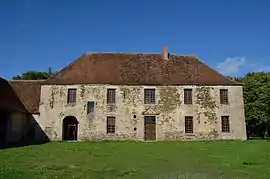 Abbey of Prébenoît | |
Location of Bétête | |
 Bétête  Bétête | |
| Coordinates: 46°21′37″N 2°04′42″E | |
| Country | France |
| Region | Nouvelle-Aquitaine |
| Department | Creuse |
| Arrondissement | Aubusson |
| Canton | Boussac |
| Intercommunality | CC Creuse Confluence |
| Government | |
| • Mayor (2020–2026) | Martial Delcuze[1] |
| Area 1 | 28.24 km2 (10.90 sq mi) |
| Population | 378 |
| • Density | 13/km2 (35/sq mi) |
| Time zone | UTC+01:00 (CET) |
| • Summer (DST) | UTC+02:00 (CEST) |
| INSEE/Postal code | 23022 /23270 |
| Elevation | 272–430 m (892–1,411 ft) (avg. 380 m or 1,250 ft) |
| 1 French Land Register data, which excludes lakes, ponds, glaciers > 1 km2 (0.386 sq mi or 247 acres) and river estuaries. | |
Geography
A farming area comprising the village and several hamlets situated some 15 miles (24 km) northeast of Guéret, at the junction of the D15, D83 and the D88. The Petite Creuse river forms most of the southern and western border of the commune.
Population
| Year | Pop. | ±% |
|---|---|---|
| 1962 | 666 | — |
| 1968 | 668 | +0.3% |
| 1975 | 651 | −2.5% |
| 1982 | 638 | −2.0% |
| 1990 | 525 | −17.7% |
| 1999 | 427 | −18.7% |
| 2008 | 359 | −15.9% |
Sights
See also
References
- "Répertoire national des élus: les maires" (in French). data.gouv.fr, Plateforme ouverte des données publiques françaises. 13 September 2022.
- "Populations légales 2020". The National Institute of Statistics and Economic Studies. 29 December 2022.
Wikimedia Commons has media related to Bétête.
This article is issued from Wikipedia. The text is licensed under Creative Commons - Attribution - Sharealike. Additional terms may apply for the media files.