Naillat
Naillat (French pronunciation: [naja]; Occitan: Nalhac) is a commune in the Creuse department in the Nouvelle-Aquitaine region in central France.
Naillat | |
|---|---|
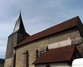 The church of Saint-Médard, in Naillat | |
Location of Naillat | |
 Naillat  Naillat | |
| Coordinates: 46°15′55″N 1°38′18″E | |
| Country | France |
| Region | Nouvelle-Aquitaine |
| Department | Creuse |
| Arrondissement | Guéret |
| Canton | Dun-le-Palestel |
| Intercommunality | CC Pays Dunois |
| Government | |
| • Mayor (2020–2026) | Laurent Tardy[1] |
| Area 1 | 36.23 km2 (13.99 sq mi) |
| Population | 628 |
| • Density | 17/km2 (45/sq mi) |
| Time zone | UTC+01:00 (CET) |
| • Summer (DST) | UTC+02:00 (CEST) |
| INSEE/Postal code | 23141 /23800 |
| Elevation | 316–530 m (1,037–1,739 ft) (avg. 360 m or 1,180 ft) |
| 1 French Land Register data, which excludes lakes, ponds, glaciers > 1 km2 (0.386 sq mi or 247 acres) and river estuaries. | |
Geography
A farming area comprising the village and several hamlets situated some 14 miles (23 km) northwest of Guéret at the junction of the D5, D14 and the D44 roads. A small tributary of the Creuse, the river Brézentine flows through the middle of the village.
Population
| Year | Pop. | ±% p.a. |
|---|---|---|
| 1968 | 1,084 | — |
| 1975 | 955 | −1.79% |
| 1982 | 809 | −2.34% |
| 1990 | 721 | −1.43% |
| 1999 | 641 | −1.30% |
| 2007 | 655 | +0.27% |
| 2012 | 675 | +0.60% |
| 2017 | 639 | −1.09% |
| Source: INSEE[3] | ||
Sights
See also
References
- "Répertoire national des élus: les maires". data.gouv.fr, Plateforme ouverte des données publiques françaises (in French). 2 December 2020.
- "Populations légales 2020". The National Institute of Statistics and Economic Studies. 29 December 2022.
- Population en historique depuis 1968, INSEE
Wikimedia Commons has media related to Naillat.
This article is issued from Wikipedia. The text is licensed under Creative Commons - Attribution - Sharealike. Additional terms may apply for the media files.