Bhaderwah
Bhaderwah or Bhadarwah (also Bhaderwah Valley) is a town, tehsil, sub-division and also additional district in the Doda district of the Jammu Division of Jammu and Kashmir, India.[4][5] It is also known as Chota Kashmir (Mini Kashmir)[6] for its scenic beauty[4] and for its high literacy rate it is known as Kerala of Jammu and Kashmir.[7]
Bhaderwah
Bhadarwah بھڈلا | |
|---|---|
| Additional District Bhaderwah | |
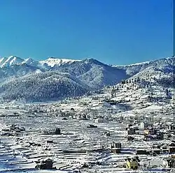 Bhaderwah in Snow | |
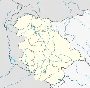 Bhaderwah Location in Jammu and Kashmir, India  Bhaderwah Bhaderwah (India) | |
| Coordinates: 32.980033°N 75.713706°E | |
| Country | |
| Union Territory | |
| Division | Jammu |
| Region | Chenab Valley |
| District | Doda |
| Area | |
| • Total | 112.17 km2 (43.31 sq mi) |
| Elevation | 1,613 m (5,292 ft) |
| Population (2011)[1] | |
| • Total | 75,376 |
| • Density | 670/km2 (1,700/sq mi) |
| Demonym | Bhaderwahi |
| Languages | |
| • Official | Urdu |
| • Other Spoken languages | Bhaderwahi, Kashmiri, Urdu |
| Time zone | UTC +05:30 (Indian Standard Time) |
| Additional District Commissioner Bhaderwah | Chowdhary Dil Mir (KAS) |
| BDC Chairperson[2] | Omi Chand[3] |
| Website | bhaderwah |
History
In 1841, Bhadarwah became part of J&K state. When Maharaja Partap Singh was crowned as king of Jammu and Kashmir, he gifted Bhadarwah to his younger brother Raja Amar Singh as "Jagir". The Jagir comprised Bhadarwah, Bhalessa and the vast area left of river Chenab from Thathri up to Khellani (Doda).[8]
Mela Pat
Mela Pat traces its origins to the sixteenth century when Emperor Akbar was deeply impressed by the spiritual aura surrounding Raja Nagpal, the ruler of Bhaderwah Principality during the 16th century.[9] This auspicious event is traditionally organized following the culmination of the Kailash Yatra in Bhaderwah and is held annually on the sacred occasion of Rishi Panchami, also recognized as Naga Panchami.[10]
Demographics
Dandi (2KM), Chinote (3KM), Gatha (4KM), Manwah ( 5KM), Nalthi (5KM) are the nearby Villages of Bhaderwah. Bhaderwah is Surrounded by Thathri Block towards North, Dudu Block towards west, Marmat block towards west, Drabshalla block towards North. Udhampur, Dalhousie, Chamba, Kathua are the nearby Places to Bhaderwah.
| Year | Pop. | ±% p.a. |
|---|---|---|
| 1911 | 2,563 | — |
| 1921 | 2,603 | +0.15% |
| 1931 | 2,895 | +1.07% |
| 1941 | 2,989 | +0.32% |
| 1951 | 3,559 | +1.76% |
| 1961 | 4,129 | +1.50% |
| 1971 | 5,211 | +2.35% |
| 1981 | 6,075 | +1.55% |
| 2001 | 10,516 | +2.78% |
| 2011 | 11,084 | +0.53% |
| Source: [1] | ||
Climate
| Climate data for Bhaderwah (1981–2010 normals, extremes 1977–2012) | |||||||||||||
|---|---|---|---|---|---|---|---|---|---|---|---|---|---|
| Month | Jan | Feb | Mar | Apr | May | Jun | Jul | Aug | Sep | Oct | Nov | Dec | Year |
| Record high °C (°F) | 21.8 (71.2) |
24.8 (76.6) |
29.6 (85.3) |
32.6 (90.7) |
38.4 (101.1) |
39.3 (102.7) |
39.4 (102.9) |
37.2 (99.0) |
35.1 (95.2) |
32.4 (90.3) |
28.7 (83.7) |
22.9 (73.2) |
39.4 (102.9) |
| Average high °C (°F) | 12.1 (53.8) |
13.1 (55.6) |
18.2 (64.8) |
23.4 (74.1) |
27.3 (81.1) |
30.5 (86.9) |
30.5 (86.9) |
29.8 (85.6) |
28.4 (83.1) |
24.6 (76.3) |
20.1 (68.2) |
14.8 (58.6) |
22.7 (72.9) |
| Average low °C (°F) | −1.0 (30.2) |
0.2 (32.4) |
3.5 (38.3) |
7.2 (45.0) |
10.1 (50.2) |
13.9 (57.0) |
16.9 (62.4) |
16.5 (61.7) |
12.4 (54.3) |
6.6 (43.9) |
3.0 (37.4) |
0.4 (32.7) |
7.5 (45.5) |
| Record low °C (°F) | −10.8 (12.6) |
−9.2 (15.4) |
−6.5 (20.3) |
−2.5 (27.5) |
0.2 (32.4) |
5.2 (41.4) |
7.0 (44.6) |
8.1 (46.6) |
2.5 (36.5) |
−3.0 (26.6) |
−2.5 (27.5) |
−6.5 (20.3) |
−10.8 (12.6) |
| Average rainfall mm (inches) | 125.3 (4.93) |
170.9 (6.73) |
171.5 (6.75) |
123.8 (4.87) |
94.1 (3.70) |
74.8 (2.94) |
141.0 (5.55) |
121.0 (4.76) |
92.2 (3.63) |
38.8 (1.53) |
35.9 (1.41) |
72.5 (2.85) |
1,262.6 (49.71) |
| Average rainy days | 6.8 | 8.5 | 8.6 | 7.5 | 7.4 | 7.1 | 9.8 | 9.3 | 4.9 | 2.6 | 2.4 | 3.9 | 78.5 |
| Average relative humidity (%) (at 17:30 IST) | 63 | 64 | 57 | 51 | 51 | 51 | 64 | 68 | 60 | 51 | 54 | 58 | 58 |
| Source: India Meteorological Department[11][12] | |||||||||||||
Tourist destinations
- Padri Top
- Chinta valley
- Sonbain
- Jai Valley
- Gupt Ganga
- Nalthi
- Fish Pond
- Chandi Mata Temple,Chinote
- Bhaderwah Fort
- Seoj Dhar
- Padri Pass
- Kansar valley
- Kailash Kund
- Vasuki Naag Temple
- Tilligarh Resort
- Jamia Masjid Bhaderwah
- Laxmi Narayan Temple
- Khanni Top
References
- A-4 Towns And Urban Agglomerations Classified By Population Size Class In 2011 With Variation Since 1901. Office of the Registrar General & Census Commissioner, Ministry of Home Affairs, Government of India (Report).
Class - IV Population of 10,000 and 19,999 (Report). - Block Development Councillor
- "Members of BDC - District Doda". India. 20 November 2019. Retrieved 1 April 2023.
- "Explore Bhaderwah in Jammu Province". Department of Tourism, Jammu and Kashmir. Retrieved 6 January 2023.
- "Administrative Setup | District Doda | India". Retrieved 7 February 2022.
- "Bhaderwah -The Chota Kashmir". Daily Excelsior. 22 October 2021. Retrieved 6 January 2023.
- "Bhaderwah". Bhaderwah Heavens. Retrieved 6 January 2023.
- Excelsior, Daily (6 February 2016). "Past, present of Doda". Daily Excelsior. Retrieved 14 June 2021.
- "Three-day historic Mela-Patt begins". Daily Excelsior. 11 September 2021. Retrieved 22 September 2023.
- "भद्रवाह में धूमधाम से संपन्न हुआ मेला पट्ट" [Mela Patt concluded with great pomp in Bhaderwah]. Punjab Kesari (in Hindi). 29 August 2017. Retrieved 22 September 2023.
- "Station: Badarwah Climatological Table 1981–2010" (PDF). Climatological Normals 1981–2010. India Meteorological Department. January 2015. pp. 57–58. Archived from the original (PDF) on 5 February 2020. Retrieved 5 March 2021.
- "Extremes of Temperature & Rainfall for Indian Stations (Up to 2012)" (PDF). India Meteorological Department. December 2016. p. M75. Archived from the original (PDF) on 5 February 2020. Retrieved 29 March 2020.