Burnhaupt-le-Haut
Burnhaupt-le-Haut (German: Oberburnhaupt[3]) is a commune in the Haut-Rhin department in Grand Est in north-eastern France.
Burnhaupt-le-Haut
Ewer-Burnhàuipt | |
|---|---|
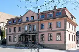 The town hall and school in Burnhaupt-le-Haut | |
 Coat of arms | |
Location of Burnhaupt-le-Haut | |
 Burnhaupt-le-Haut 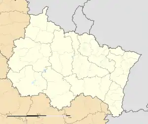 Burnhaupt-le-Haut | |
| Coordinates: 47°43′51″N 7°08′46″E | |
| Country | France |
| Region | Grand Est |
| Department | Haut-Rhin |
| Arrondissement | Thann-Guebwiller |
| Canton | Masevaux-Niederbruck |
| Intercommunality | Vallée de la Doller et du Soultzbach |
| Government | |
| • Mayor (2020–2026) | Véronique Sengler-Waltz[1] |
| Area 1 | 12.49 km2 (4.82 sq mi) |
| Population | 1,744 |
| • Density | 140/km2 (360/sq mi) |
| Time zone | UTC+01:00 (CET) |
| • Summer (DST) | UTC+02:00 (CEST) |
| INSEE/Postal code | 68060 /68520 |
| Elevation | 290–338 m (951–1,109 ft) (avg. 300 m or 980 ft) |
| Website | www |
| 1 French Land Register data, which excludes lakes, ponds, glaciers > 1 km2 (0.386 sq mi or 247 acres) and river estuaries. | |
See also
References
- "Répertoire national des élus: les maires". data.gouv.fr, Plateforme ouverte des données publiques françaises (in French). 2 December 2020.
- "Populations légales 2020". The National Institute of Statistics and Economic Studies. 29 December 2022.
- Guerre, France Ministre de la (1892). Journal des sciences militaires (in French). p. 315.
Wikimedia Commons has media related to Burnhaupt-le-Haut.
This article is issued from Wikipedia. The text is licensed under Creative Commons - Attribution - Sharealike. Additional terms may apply for the media files.