Cítov
Cítov is a municipality and village in Mělník District in the Central Bohemian Region of the Czech Republic. It has about 1,300 inhabitants.
Cítov | |
|---|---|
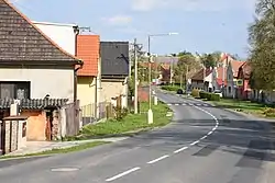 Western part of Cítov | |
 Flag 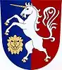 Coat of arms | |
 Cítov Location in the Czech Republic | |
| Coordinates: 50°22′20″N 14°23′54″E | |
| Country | |
| Region | Central Bohemian |
| District | Mělník |
| First mentioned | 1268 |
| Area | |
| • Total | 15.80 km2 (6.10 sq mi) |
| Elevation | 181 m (594 ft) |
| Population (2023-01-01)[1] | |
| • Total | 1,288 |
| • Density | 82/km2 (210/sq mi) |
| Time zone | UTC+1 (CET) |
| • Summer (DST) | UTC+2 (CEST) |
| Postal code | 277 04 |
| Website | www |
Administrative parts
The village of Daminěves is an administrative part of Cítov.
Geography
Cítov is located about 5 kilometres (3 mi) west of Mělník and 28 km (17 mi) north of Prague. It lies mostly in the Central Elbe Table. The northern part of the municipality extends into the Lower Eger Table and includes the highest point of Cítov at 240 m (790 ft) above sea level.
History
The first written mention of Cítov is in a deed of King Ottokar II from 1268. From 1782 until the establishment of an independent municipality, it was owned by the Lobkowicz family. The village was predominantly agricultural.[2]
Sights
The landmark of Cítov is the Church of Saint Leonard. It is originally a Romanesque church, rebuilt in the Baroque style in 1753.[3]
References
- "Population of Municipalities – 1 January 2023". Czech Statistical Office. 2023-05-23.
- "Historie" (in Czech). Obec Cítov. Retrieved 2023-03-21.
- "Kostel sv. Linharta" (in Czech). National Heritage Institute. Retrieved 2023-03-21.