Cantigny, Somme
Cantigny (French pronunciation: [kɑ̃tiɲi]) is a commune in the Somme department in Hauts-de-France in northern France.
Cantigny | |
|---|---|
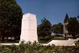 The Cantigny Memorial | |
Location of Cantigny | |
 Cantigny  Cantigny | |
| Coordinates: 49°39′51″N 2°29′35″E | |
| Country | France |
| Region | Hauts-de-France |
| Department | Somme |
| Arrondissement | Montdidier |
| Canton | Roye |
| Intercommunality | CC Grand Roye |
| Government | |
| • Mayor (2020–2026) | Noël Bauwens[1] |
| Area 1 | 4.03 km2 (1.56 sq mi) |
| Population | 110 |
| • Density | 27/km2 (71/sq mi) |
| Time zone | UTC+01:00 (CET) |
| • Summer (DST) | UTC+02:00 (CEST) |
| INSEE/Postal code | 80170 /80500 |
| Elevation | 64–112 m (210–367 ft) (avg. 104 m or 341 ft) |
| 1 French Land Register data, which excludes lakes, ponds, glaciers > 1 km2 (0.386 sq mi or 247 acres) and river estuaries. | |
History
During World War I, a battle liberated the town from German forces. Major General Robert Lee Bullard commanded the US First Division in the United States' first victory of the war. About 10 years later, Colonel Robert R. McCormick named his estate in Illinois after the town.
Geography
Cantigny is situated on the D28 road, some 20 miles (32 km) southeast of Amiens.
Population
| Year | Pop. | ±% p.a. |
|---|---|---|
| 1968 | 117 | — |
| 1975 | 116 | −0.12% |
| 1982 | 123 | +0.84% |
| 1990 | 131 | +0.79% |
| 1999 | 124 | −0.61% |
| 2007 | 116 | −0.83% |
| 2012 | 105 | −1.97% |
| 2017 | 114 | +1.66% |
| Source: INSEE[3] | ||
See also
References
- "Répertoire national des élus: les maires". data.gouv.fr, Plateforme ouverte des données publiques françaises (in French). 2 December 2020.
- "Populations légales 2020". The National Institute of Statistics and Economic Studies. 29 December 2022.
- Population en historique depuis 1968, INSEE
This article is issued from Wikipedia. The text is licensed under Creative Commons - Attribution - Sharealike. Additional terms may apply for the media files.