Saveuse
Saveuse (French pronunciation: [savøz]) is a commune in the Somme department in Hauts-de-France in northern France.
Saveuse | |
|---|---|
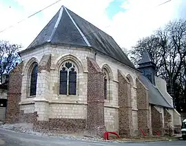 The church in Saveuse | |
 Coat of arms | |
Location of Saveuse | |
 Saveuse  Saveuse | |
| Coordinates: 49°54′02″N 2°13′06″E | |
| Country | France |
| Region | Hauts-de-France |
| Department | Somme |
| Arrondissement | Amiens |
| Canton | Ailly-sur-Somme |
| Intercommunality | Amiens Métropole |
| Government | |
| • Mayor (2020–2026) | Georges Dufour[1] |
| Area 1 | 3.99 km2 (1.54 sq mi) |
| Population | 1,067 |
| • Density | 270/km2 (690/sq mi) |
| Time zone | UTC+01:00 (CET) |
| • Summer (DST) | UTC+02:00 (CEST) |
| INSEE/Postal code | 80730 /80470 |
| Elevation | 39–105 m (128–344 ft) (avg. 80 m or 260 ft) |
| 1 French Land Register data, which excludes lakes, ponds, glaciers > 1 km2 (0.386 sq mi or 247 acres) and river estuaries. | |
Geography
Saveuse is situated 3 miles (5 km) west of Amiens, on the D211 road
Population
| Year | Pop. | ±% p.a. |
|---|---|---|
| 1968 | 355 | — |
| 1975 | 604 | +7.89% |
| 1982 | 858 | +5.14% |
| 1990 | 864 | +0.09% |
| 1999 | 776 | −1.19% |
| 2007 | 719 | −0.95% |
| 2012 | 810 | +2.41% |
| 2017 | 932 | +2.85% |
| Source: INSEE[3] | ||
Places of interest
- The church

At the entrance to the commune
See also
References
- "Répertoire national des élus: les maires". data.gouv.fr, Plateforme ouverte des données publiques françaises (in French). 2 December 2020.
- "Populations légales 2020". The National Institute of Statistics and Economic Studies. 29 December 2022.
- Population en historique depuis 1968, INSEE
Wikimedia Commons has media related to Saveuse.
This article is issued from Wikipedia. The text is licensed under Creative Commons - Attribution - Sharealike. Additional terms may apply for the media files.