Grattepanche
Grattepanche (French pronunciation: [ɡʁatpɑ̃ʃ]) is a commune in the Somme department in Hauts-de-France in northern France.
Grattepanche | |
|---|---|
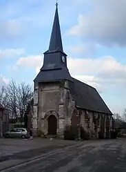 The church in Grattepanche | |
.svg.png.webp) Coat of arms | |
Location of Grattepanche | |
 Grattepanche  Grattepanche | |
| Coordinates: 49°47′17″N 2°17′41″E | |
| Country | France |
| Region | Hauts-de-France |
| Department | Somme |
| Arrondissement | Amiens |
| Canton | Ailly-sur-Noye |
| Intercommunality | Amien Métropole |
| Government | |
| • Mayor (2020–2026) | Bruno Bardet[1] |
| Area 1 | 6.43 km2 (2.48 sq mi) |
| Population | 323 |
| • Density | 50/km2 (130/sq mi) |
| Time zone | UTC+01:00 (CET) |
| • Summer (DST) | UTC+02:00 (CEST) |
| INSEE/Postal code | 80387 /80680 |
| Elevation | 69–125 m (226–410 ft) (avg. 100 m or 330 ft) |
| 1 French Land Register data, which excludes lakes, ponds, glaciers > 1 km2 (0.386 sq mi or 247 acres) and river estuaries. | |
Geography
Grattepanche is situated on the D75e road, some 10 miles (16 km) south of Amiens.
Population
| Year | Pop. | ±% p.a. |
|---|---|---|
| 1968 | 120 | — |
| 1975 | 148 | +3.04% |
| 1982 | 179 | +2.75% |
| 1990 | 243 | +3.89% |
| 1999 | 269 | +1.14% |
| 2007 | 287 | +0.81% |
| 2012 | 290 | +0.21% |
| 2017 | 318 | +1.86% |
| Source: INSEE[3] | ||
Places of interest
- The church
- The war memorial
- The calvary
See also
References
- "Répertoire national des élus: les maires". data.gouv.fr, Plateforme ouverte des données publiques françaises (in French). 2 December 2020.
- "Populations légales 2020". The National Institute of Statistics and Economic Studies. 29 December 2022.
- Population en historique depuis 1968, INSEE
External links
Wikimedia Commons has media related to Grattepanche.
- Official municipal website (in French)
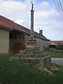 The calvary
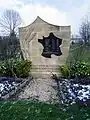 The war memorial
This article is issued from Wikipedia. The text is licensed under Creative Commons - Attribution - Sharealike. Additional terms may apply for the media files.